More From Contributor

£11.99
Triglav National Park at 1:50, 000 on a contoured & GPS compatible walking & cycling map from Kartografija in Ljubljana, waterproof & tear-resistant version, with on the reverse descriptions of the area’s best sights. Coverage extends from Bovec in the west to Bled in the east, & from Kranjska Gora in the north to just short of Tolmin in the south. On the reverse are bilingual descriptions of the region’s places of interest, including special notes on the World War I Isonzo Front, plus list of mountain huts & campsites with contact details. Maps in this series have contours at 20m intervals, enhanced by relief shading, with plenty of spot heights & names of peaks, mountain chains, etc. Local hiking routes are highlighted, indicating difficult passages. Also marked are recommended cycling routes. Symbols indicate various types of accommodation including mountain huts, campsites, inns with lodgings, tourist farms or apartments, hotels & motels, as well as recreational facilities (golf, horse riding, swimming pools, etc), vineries, cultural & historical sites, etc. Road network indicates locations of petrol stations. Railway lines are shown with stations & various types of mountain transport (gondolas, chair lifts, etc) are marked. The maps have a latitude & longitude grid at intervals of 2’’. Map legend & all the text include English. To see the list of titles in this series, including alternative coverage of the Triglav National Park, please click on the series. ...
Archived Product
£8.99
The central area of the Triglav National Park around the peak of Triglav at 1:25, 000 on a contoured, GPS compatible pocket map from Kartografija, with hiking trails, including brief descriptions of eight recommended routes, mountain huts, interesting natural sites, etc. Along the lower slopes a few cycling routes are also highlighted. Kartografija’s pocket hiking maps at 1:25, 000 show walking trails & cycling routes, along with numerous tourist facilities & recreational sites. Topography is shown by contours at 20m intervals enhanced by relief shading & graphic relief to show exposed rocky areas, plus colouring for woodlands. Hiking trails & cycling routes are prominently highlighted, & symbols indicate locations of various accommodation options including campsites & mountain huts, sport & recreational sites & facilities, natural features of particular interest, etc. The maps have a grid with latitude & longitude lines at 1’ intervals. Map legend

Includes::
English. On the reverse each map has extensive bilingual Slovenian/ English text with more tourist information, illustrated with colour photos. To see the list of all the titles in this series please click on the series link.

...
Archived Product
£13.99
The central part of the Triglav National Park with the peak of Triglav & Kranjska Gora on a contoured & GPS compatible map at 1:25, 000 from Planinska zveza Slovenie
- Slovenian Alpine Club, with on the reverse details of 22 local mountain refuges with OR codes for further information & recommended hiking trails. The map very vividly presents the areas topography by contours at 10m intervals, enhanced by shading & graphic relief plus spot heights. An overprint highlights local & long-distance hiking trails, indicating difficult and/or via ferrata sections. Also shown are recommended cycling routes. Locations of mountain refuges & cabins are prominently marked & symbols indicate other facilities & places of interest including campsites, local inns & hotels, cultural & historical sites, etc. Road network shows bus stops as well as car parks & petrol stations. The map has a 1km UTM grid plus latitude & longitude crosshairs at 1’ intervals. On the reverse 22 mountain refuges are listed with details such as capacity, seasonal opening, etc, plus their GPS coordinates & QR codes for more information. Each refuge also shows approximate hiking times to the nearest mountain refuge/hut. Also provided are descriptions of six recommended routes to the peak of Triglav. Map legend & the text include English.PLEASE NOTE: map numbers given to the individual titles on our website correspond to our grid & may not necessarily be the same the numbers allocated by the publishers & shown on the different grids on the reverse of the various titles.
...
Archived Product
£6.50
Topographic coverage of mainland Spain at 1:25, 000 published by the Centro Nacional de Información Geograficá, the country’s civilian survey organization. The maps have contours at 10m intervals & colouring and/or graphics to show different types of vegetation or land use. Boundaries of national parks & other protected areas are marked. In addition to all the usual information shown on topographic maps at this scale, detailed presentation of the road & rail networks, rural tracks & paths, etc, the maps also show campsites. The maps have a 1-km UTM grid, with margin ticks for latitude & longitude at 1` intervals. Map legend is in Spanish only.PLEASE NOTE: our grid for the whole of Spain is in preparation
- in the meantime, for areas other than those shown on the attached grid please use CNIG’s topographic survey at 1:50, 000 by searching for ‘SI00000832’. Each 25K map covers one quarter of the corresponding 50K map, with the numbering system: I = NW quarter, II = NE quarter, III = SW quarter & IV = SE quarter. CNIG maps in the Provincial Road Maps series at 1:200, 000 are overprinted with the grid for the 1:50, 000 survey & can be used to see the area covered by each 50K or 25K title in more detail. To see the list of titles in this series please click on the series grid
- for map numbers not yet listed on our website please contact us by email.

...
Archived Product
£23.99
Trillemarka-Rollagsfjell area in Norway in a series of GPS compatible recreational maps at 1:50, 000 with cartography from Norway’s topographic survey & additional tourist information. Contours lines are drawn at 20m intervals. The overprint varies from title to title, but

Includes::
local footpaths, in some cases distinguishing between easy & more difficult trails, as well as mountain huts & campsites. Many titles also indicate cycle or ski routes, other accommodation possibilities, sport & recreational facilities, including alpine skiing slopes, places of interest, etc. The maps have a UTM grid & margin ticks giving latitude & longitude. Map legend

Includes::
English. Several titles have on the reverse additional tourist information, although in most cases in Norwegian only.PLEASE NOTE: This title is also available as part of a 2-map set which

Includes::
the Voss map at 1:25, 000. To see the list of Turkart maps at 1:50, 000 & links to Turkart series at 25K, 100K & Hiking Sets please click on the series link above.


...
Archived Product
£8.99
The stories in this collection nearly all take place in & around the mountain hollows of West Virginia: a world of cock-fighting, coal-mining, deer-stalking, sex, depression, drinking & death. ” It would be easy to allow his one collection of stories to be buried under the landslide of books published every year. But it`s worth doing a little excavating to dig it up. The past few years have seen late-in-the-day & posthumous revivals of interest in writers such... John Williams. Get out your pickaxes”. (New Yorker). ...
Archived Product
£3.50
Trimdon Grange in 1914 in a fascinating series of reproductions of old Ordnance Survey plans in the Alan Godfrey Editions, ideal for anyone interested in the history of their neighbourhood or family. The map covers two villages, Trimdon Grange, near the centre of the map & much of Trimdon Colliery about half a mile away. Features include Trimdon Grange Colliery, old quarries, Trimdon Colliery (disused), the Ferryhill & East Hartlepool railway, Trimdon station, Deaf Hill, St Paul`s church, etc. The villages are shown in detail, with railway tracks, houses & outhouses. On the reverse is an 1894 directory of Trimdon. About the Alan Godfrey Editions of the 25” OS Series: Selected towns in Great Britain & Ireland are covered by maps showing the extent of urban development in the last decades of the 19th & early 20th century. The plans have been taken from the Ordnance Survey mapping & reprinted at about 15 inches to one mile (1:4, 340). On the reverse most maps have historical notes & many also include extracts from contemporary directories. Most maps cover about one mile (1.6kms) north/south, one & a half miles (2.4kms) across; adjoining sheets can be combined to provide wider coverage.FOR MORE INFORMATION & A COMPLETE LIST OF ALL AVAILABLE TITLES PLEASE CLICK ON THE SERIES LINK. ...
Archived Product
£3.50
Tring in 1897 in a fascinating series of reproductions of old Ordnance Survey plans in the Alan Godfrey Editions, ideal for anyone interested in the history of their neighbourhood or family. The town itself is in the top half of the map & features there include the parish church, Dunsley Cottage, The Mansion, malthouses, Home Farm, Elm House, Church House, Parsonagebottom Farm, Okeford, Frogmore, High Street, cattle market, King Street, Western Road, etc. Coverage extends south to much of Tring Park, & westward to the cemetery & West Leith. Please note that the station is not on the map. A directory of Tring in 1899 is included on the reverse. About the Alan Godfrey Editions of the 25” OS Series: Selected towns in Great Britain & Ireland are covered by maps showing the extent of urban development in the last decades of the 19th & early 20th century. The plans have been taken from the Ordnance Survey mapping & reprinted at about 15 inches to one mile (1:4, 340). On the reverse most maps have historical notes & many also include extracts from contemporary directories. Most maps cover about one mile (1.6kms) north/south, one & a half miles (2.4kms) across; adjoining sheets can be combined to provide wider coverage.FOR MORE INFORMATION & A COMPLETE LIST OF ALL AVAILABLE TITLES PLEASE CLICK ON THE SERIES LINK. ...
Archived Product
£11.19
Trinidad & Tobago in the Countries, Regions & Cities series from Rough Guides; comprehensively detailed guidebooks specifically designed for independent travellers & serving a range of worldwide destinations. Widely recognised for their free editorial style, Rough Guide authors are allowed to express their personal opinions on a range of subjects. Although sometimes controversial, this editorial stance allows readers to experience more detailed & personal takes on each destination, a feature often more limited in other guidebooks. Cultural & historical nuances are explored in significant depth throughout the text & descriptions on the ambience of individual settings alongside personal recommendations, particularly in cities, are notably prevalent. Each Rough Guide in the Countries, Regions & Cities series has a similar layout. A ...
Archived Product
£6.95
Trinidad & Tobago in the Culture Smart range of pocket-sized guide books; providing detailed information on local customs, culture, etiquette & manners & ensuring that visitors are prepared for a diverse range of social environments. The series covers an extensive number of countries worldwide & are designed both for those working & living abroad, as well as for visitors who do not want to offend, either intentionally or inadvertently. Their aim is to prevent readers from making embarrassing mistakes & feel confident in unfamiliar situations, while preparing them before arrival on what to expect & how to behave. Each guide is arranged thematically, with dedicated individual chapters on land & people, values & attitudes, customs & traditions, making friends, people at home, ‘time-out’, travelling & communicating. There is also a separate chapter for business travelers, with important information on subjects such as business culture, meetings & making appointments. A Further Reading section also offers a list of recommended other history, travel literature & language titles available on the country. ...
Archived Product

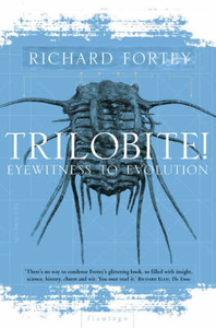
Trilobite: Eyewitness To Evolution

`In Richard Fortey`s capable hands the humble grey trilobite has been transformed into the E.T. of the Lower Palaeozoic - a remarkable and fascinating book.` SIMON WINCHESTER Richard Fortey is one of Britain`s leading popular scientists. Life: An Unauthorised Biography, was short-listed for the Rhone Poulenc prize and has been reprinted five times. In all he writes, Fortey displays extraordinary range, delight and descriptive gifts which make complicated scientific facts and concepts not only easy to understand but a delight to absorb. Trilobite! is an unashamedly trilobito-centric view of the world unravelling the history of the exotic, crustacean-like animals which dominated the seas for three hundred million years. These arthropods witnessed continents move, mountain chains
elevated and eroded; they survived ice ages and volcanic eruptions, evolving and adapting exquisitely to their environment. They watched through their crystal eyes whilst life evolved. Their own evolution calibrated geological time itself.Structured like a detective story, this is a light, but highly informative account of the wonders of scientific discovery and an engaging, quirky and fascinating introduction to evolution.
RIP - This product is no longer available on our network. It was last seen on 25.09.2019

This page now acts as a permanent archive for this product. Add more information using the comments box below to ensure it can still be found by future generations.

Use our search facility to see if it is available from an alternative contributor.
  • External links may include paid for promotion
  • Availability: Out Of Stock
  • Supplier: Stanfords
  • SKU: 9780006551386
Availability: In Stock
£9.99

Product Description

` In Richard Fortey`s capable hands the humble grey trilobite has been transformed into the E.T. of the Lower Palaeozoic
- a remarkable & fascinating book.` SIMON WINCHESTER Richard Fortey is one of Britain`s leading popular scientists. Life: An Unauthorised Biography, was short-listed for the Rhone Poulenc prize & has been reprinted five times. In all he writes, Fortey displays extraordinary range, delight & descriptive gifts which make complicated scientific facts & concepts not only easy to understand but a delight to absorb. Trilobite! is an unashamedly trilobito-centric view of the world unravelling the history of the exotic, crustacean-like animals which dominated the seas for three hundred million years. These arthropods witnessed continents move, mountain chains elevated & eroded; they survived ice ages & volcanic eruptions, evolving & adapting exquisitely to their environment. They watched through their crystal eyes whilst life evolved. Their own evolution calibrated geological time itself. Structured like a detective story, this is a light, but highly informative account of the wonders of scientific discovery & an engaging, quirky & fascinating introduction to evolution.

Reviews/Comments

Add New

Intelligent Comparison

Oooops!
We couldn't find anything!
Perhaps this product's unique.... Or perhaps we are still looking for comparisons!
Click to bump this page and we'll hurry up.

Price History

Vouchers

No voucher codes found.
Do you know a voucher code for this product or supplier? Add it to Insights for others to use.

Facebook

Jargon Buster

Ice - Frozen water, the solid state of water.
Grey - A colour often associated with old age (going grey)
History - Anything that happens in the past. An acedemic subject.
World - A physical grouping, commonly used to describe earth and everything associated with ti
Ice - Frozen water, Ice is cold to the touch and forms when water reaches 0 degrees centigrade.
Crystal - A solid substance that has symmetrically carved plane faces and can be regularly found in jewellery.
Crystal - A solid clear substance with many surfaces that glisten, commonly used in jewellery
Popular - Something that is admired and liked by many people.
Crystal - A solid substance with symmetrically arranged planes, commonly found in jewellery.
Environment - The conditions and surrounding area.

Supplier Information

Stanfords
Stanfords was established in 1853 and opened their iconic Covent Garden flagship store in 1901. They have become the top retailer of maps, travel books and accessories in the UK and arguably offer the largest selection of maps and travel books worldwide. Famous names such as Captain Robert Falcon Scott, Ranulph Fiennes and Michael Palin have purchased from Stanfords. They now have a shop in Bristol and both stores together with other venues operate a calendar of events including talks, book signings and exhibitions. As a specialist map retailer, the map selection is comprehensive and includes road maps, street maps and walking maps from worldwide destinations, as well as a selection of world atlases and wall maps. Books include travel guides and travel literature. Stanfords also stock globes, from miniatures made of blue marble to magnificent floor-standing globes. The website features a selection of interesting articles on travel topics.
Page Updated: 2023-11-12 20:15:36

Community Generated Product Tags

Oh No! The productWIKI community hasn't generated any tags for this product yet!
Menu