
 United Kingdom
 France
 Germany
 Netherlands
 Sweden
 USA
USA
 Italy
Italy
 Spain
Spain
More From Contributor


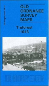
Treforest 1943
Treforest in 1943 in a fascinating series of reproductions of old Ordnance Survey plans in the Alan Godfrey Editions, ideal for anyone interested in the history of their neighbourhood or family. The map covers Treforest, at the eastern edge of Pontypridd, including Glyn-Taf (sometimes spelt Glyn-Taff or Glyntaff), and part of Rhyd-y-Felin. Coverage stretches from King Street eastward to Coed Craig-lwyd and Pant-drain. Features include River Taff, Castle Bridge, School of Mines, GWR Cardiff & Merthyr line with station, Caerphilly & Pontypridd line with several halts, Glamorganshire Canal, Glyn-Taf Cemetery, Taff Vale Park, Pentre-Bach, Junior Technical School, schools, chapels, Lewistown Park, St Dyfrig`s RC church, St Mary`s church, Dynea Colliery (disused), Glyn-Taf,
old mineral tramway route, Treforest Junction, Electrical Works, etc. On the reverse is a 1906 directory of Treforest, plus a 1929 railway timetable for the Newport-Pontypridd line.About the Alan Godfrey Editions of the 25” OS Series:Selected towns in Great Britain and Ireland are covered by maps showing the extent of urban development in the last decades of the 19th and early 20th century. The plans have been taken from the Ordnance Survey mapping and reprinted at about 15 inches to one mile (1:4, 340). On the reverse most maps have historical notes and many also include extracts from contemporary directories. Most maps cover about one mile (1.6kms) north/south, one and a half miles (2.4kms) across; adjoining sheets can be combined to provide wider coverage.FOR MORE INFORMATION AND
A COMPLETE LIST OF ALL AVAILABLE TITLES PLEASE CLICK ON THE SERIES LINK.

Product Description
Reviews/Comments
Add New
Vouchers
No voucher codes found.
Do you know a voucher code for this product or supplier? Add it to Insights for others to use.
Do you know a voucher code for this product or supplier? Add it to Insights for others to use.
 Denmark