
 United Kingdom
 France
 Germany
 Netherlands
 Sweden
 USA
USA
 Italy
Italy
 Spain
Spain
More From Contributor


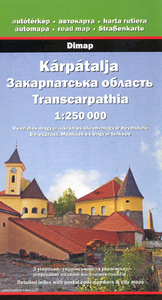
Transkarpathia
Transkarpathia or the Zakarpatska Oblast - the south-western corner of the Ukraine on a detailed contoured road map at 1;250, 000 from Dimap, with street plans of Uzhhorod, Beregovo and Mukachevo.The map has contours at 100m intervals to show the region’s mountainous terrain. Road network includes unpaved local roads and country tracks, with driving distance shown on main routes and locations of border crossings. Railway lines are shown with stations and indicate narrow gauge lines. Symbols highlight various places of interest including wooden churches, distinguishing, in keeping with the region’s varied history, between six different religions. Names of towns and villages are given in Cyrillic alphabet, accompanied by their historic Hungarian versions. Names of peaks are also
given in bilingual versions; mountain ranges are identified in Hungarian only. The map has no geographical coordinates. The map also provides street plans of Uzhhorod (Uzhgorod), Beregovo (Berehove/Beregove), and Mukachevo (Mukacheve), annotated with tourist accommodation and places of interest. Both the main map and the plans are indexed and accompanied by tables comparing current Ukrainian and the old Hungarian names and providing other historical information.Map legend includes English. All other information is in Ukrainian and Hungarian only.
given in bilingual versions; mountain ranges are identified in Hungarian only. The map has no geographical coordinates. The map also provides street plans of Uzhhorod (Uzhgorod), Beregovo (Berehove/Beregove), and Mukachevo (Mukacheve), annotated with tourist accommodation and places of interest. Both the main map and the plans are indexed and accompanied by tables comparing current Ukrainian and the old Hungarian names and providing other historical information.Map legend includes English. All other information is in Ukrainian and Hungarian only.

Product Description
Reviews/Comments
Add New
Vouchers
No voucher codes found.
Do you know a voucher code for this product or supplier? Add it to Insights for others to use.
Do you know a voucher code for this product or supplier? Add it to Insights for others to use.
 Denmark