More From Contributor
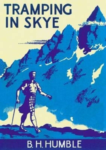
£16.99
Conrad de Lancey has seen enough of evil: the shadow of fear on the faces of innocents; the roar of tanks through empty streets; the sudden lull before the slaughter begins. Franco`s bloody insurrection taught this Englishman all about hell. Arriving in his mother`s country, the now Nazi Germany, Conrad is sick at heart. Even Berlin
- infamous haven of decadence & vice
- salutes fascism. Himmler`s black-shirted troops rule the city, & every German arm bears a Swastika. But does every German heart belong to Hitler? When Conrad is arrested by the Gestapo on suspicion of spying, he is rescued by Theo, an old friend from university, now a lieutenant of the Wehrmacht. Together they are drawn into a world of danger & deceit, of plots, paranoia & intrigue where the brave few are united by a single ambition: to free the fatherland from the Fuhrer.

...
Archived Product
£9.95
Trakai Historical National Park at 1:100, 000 in a series GPS compatible regional maps of Lithuania from Alma Littera prominently highlighting each area’s best sights & showing a wide range of other places of interest including campsites. Main roads are graded according to the speed limit; regional & local roads indicate asphalted or gravel routes. Driving distances are marked on main & selected regional routes, & locations of petrol stations & border crossings are marked. Railway lines are shown with stations. Important sights are prominently highlighted & a very wide range of symbols indicate various places of interest, including campsites, historical & industrial heritage, archaeological & natural sites, etc. The maps also indicate hiking, cycling & kayaking routes. Topography is shown by contours & spot heights, plus colouring and/or graphics for different types of the terrain & vegetation, e.g. swamps, peat bog, orchards, forests, etc. The maps have latitude & longitude lines at 5’ & 10’ respectively. Map legend

Includes::
English. Each title comes with a booklet attached to the map cover providing descriptions of places of interest, but the text here is in Lithuanian only.

...
Archived Product
£8.99
In an African city in secession land tourists of all languages & nationalities. They have only one desire: to make a fortune by exploiting the mineral wealth of the country. They work during the day in mining concession &, as soon as night falls, they go out to get drunk, dance, eat & abandon themselves in Tram 83, the only night-club of the city, the den of all the outlaws. Lucien, a professional writer, fleeing the exactions & the censorship, finds refuge in the city thanks to Requiem, a friend. Requiem lives mainly on theft & on swindle while Lucien only thinks of writing & living honestly. Around them gravitate gangsters & young girls, retired or runaway men, profit-seeking tourists & federal agents of a non-existent State. Tram 83 plunges the reader into the atmosphere of a gold rush as cynical as, it is comic & colourfully exotic. It`s an observation of human relationships in a world that has become a global village, an African-rhapsody novel hammered by rhythms of jazz. ...
Archived Product
£11.19
Tramping in New Zealand in the Walking Guide series from Lonely Planet; profiling in comprehensive detail the walking opportunities, from day walks to long distance hikes, available in a range of international destinations. Frank & informal in style, the guides introduce readers to a selection of walks in each country & are designed to be practical for use while travelling on the road. Each walk has been researched by a team of independent experts & is fully independent in its recommendations & suggestions, often offering individual takes on particular walks or treks. Widely recognised for their reliability, each Lonely Planet walking guide has the same layout, covering an extensive list of walks geographically by region. Introductory chapters provide facts about the country, including history, geography, geology & climate, as well as important facts for the walker such as suggested itineraries, when to walk, responsible walking, accommodation, food & drink, maps & weather information. There is also a dedicated clothing & equipment section, providing practical advice on what take, including relevant navigation equipment. A Health & safety section advises on pre-departure planning, staying healthy & safety on the walk or trek. Each guide is organised geographically by region, with further sub-regions also considered in each chapter. There is a selection of local stories, history & fact boxes about particular features of some of the routes throughout each guide. Each regional section gives general advice on relevant books & maps, climate, accommodation, places to eat & getting there & away. Individual walks or treks are described in extensive detail & fact boxes gives practical information on duration, distance, difficulty rating, start & finish points, the nearest town, local transport & a short summary of the route. Black & white sketch maps also provide an overview of the location of the walks in the region. A Travel Facts section at the back of each guide provides useful guidance & practical information on tourist offices, visas & documents, embassies, customs, money, post & communication, time, electricity, business hours, public holidays, getting there & away as well as getting around between each walk or trek. ...
Archived Product
£24.99
Tramping in New Zealand is a highly innovative new tramping guide, that has been developed around the latest generation of 'bird's eye' computer-generated maps. These completely accurate panoramic overviews are constructed from map data, but because they can recreate a view of the landscape from any angle or height they provide a remarkably readable & clear way of understanding the lie of the l&. For trampers, these bird's eye maps offer a superb way of showing a tramping route in three

Dimensions, which cannot be done with a conventional topographical map. In this book the 40 most popular tramps in New Zealand are featured, each illustrated with at least one bird's eye map. These have been created by Wellington company Geographx, whose cutting-edge maps feature in the acclaimed New Zealand Geographic Atlas. The maps are also supported by relevant route information & photographs from one of New Zealand's most respected tramping authors, Shaun Barnett. The tramps covered include our best known Great Walks, such as the Milford Track, the Routeburn & the Tongariro Crossing, & many others from both islands, such as the Queen Charlotte Track, the Rees Dart near Queenstown, & the Pinnacles Hut on the Coromandel. With such a high degree of readability & visual appeal combined with the highest quality information & photographs, Tramping in New Zealand creates a new benchmark for this kind of guidebook, & is set to become a classic in this popular genre.

...
Archived Product
£16.99
Sverigeserien is an outdoor map series consisting of 116 sheets with coverage of southern & central Sweden & the northern coastline. The map is suitable for outdoor activities such as hiking, excursions, trail running, hunting, fishing, riding, cycling, mountain biking, paddling, skating & much more. Every sheet covers an area of 45x 68km. These topographical maps in scale 1:50 000 contain all the information needed for outdoor activities: Terrain information, hiking trails, illuminated tracks, camping, shelters, golf courses, leisure baths, historical remains, roads in different categories, railway lines & much more. Easy to read topography with contour lines, vertical interval 5 m. Sverigeserien is a high-quality map series & is durable for frequent use! Updated content with map data from Lantmäteriet (National Land Survey of Sweden) & printed on Polyart which is water & tear resistant. This means that the map can be folded repeatedly without breaking & can withstand the challenging weather in Sweden during both winter & summer. Legend is in Swedish, English & German. ...
Archived Product
£16.99
Topographic survey of Sweden at 1:50, 000, the Terrängkartan, from the Lantmäteriet, covering most of the country in 244 double-sided maps. Please note: the mountainous regions of central & northern Sweden are not covered by this series but presented in a separate “ Fjällkartan
- Mountain Map” series also listed on our website. Each 1:50, 000 topographic survey map covers an area of 37.5 x 40km. The maps have contours at 5 metre intervals, plus relief shading & graphics for rocky outcrops & boulders. Further graphics and/or colouring show different types of land use or vegetation (forests, arable l&, orchards, marshes, peat bogs, etc). An unusual feature of this survey is the colouring indicating buildings below or above two storeys high & “leisure/holiday homes”. The maps indicate privately maintained roads & include all other information expected of topographic survey at this scale. The maps have a 1-km UTM grid, plus latitude & longitude lines 5’ intervals. Map legend

Includes::
English. For coverage of the country’s most visited hiking areas in central & northern Sweden please see Lantmäteriet’s Mountain Map series, listed separately on our website.


...
Archived Product
£16.99
Topographic survey of Sweden at 1:50, 000, the Terrängkartan, from the Lantmäteriet, covering most of the country in 244 double-sided maps. Please note: the mountainous regions of central & northern Sweden are not covered by this series but presented in a separate “ Fjällkartan
- Mountain Map” series also listed on our website. Each 1:50, 000 topographic survey map covers an area of 37.5 x 40km. The maps have contours at 5 metre intervals, plus relief shading & graphics for rocky outcrops & boulders. Further graphics and/or colouring show different types of land use or vegetation (forests, arable l&, orchards, marshes, peat bogs, etc). An unusual feature of this survey is the colouring indicating buildings below or above two storeys high & “leisure/holiday homes”. The maps indicate privately maintained roads & include all other information expected of topographic survey at this scale. The maps have a 1-km UTM grid, plus latitude & longitude lines 5’ intervals. Map legend

Includes::
English. For coverage of the country’s most visited hiking areas in central & northern Sweden please see Lantmäteriet’s Mountain Map series, listed separately on our website.


...
Archived Product
£3.50
Tranmere & Oxton in 1909 in a fascinating series of reproductions of old Ordnance Survey plans in the Alan Godfrey Editions, ideal for anyone interested in the history of their neighbourhood or family. The map covers the southern area of Birkenhead around Tranmere, Devonshire Park & east Oxton. Coverage stretches from Oxton Hall & Talbot Road eastward to Old Chester Road, & from Grange Mount southward to Tranmere Hall & Prenton Road East. Features include football ground, Devonshire Park, tramways, Mersey Park, Arno Hill, Southgrove Nursery, Birkenhead Workhouse, Apple Grove, Oxton Hill Nursery, St Mark`s church, St Saviour`s church (at western edge of map), Clifton Park, many villas to the west & terraces further east, Holt House, St Luke`s church, engine shed, Central station, etc. On the reverse are selections from a street directory, including Borough Road, Church Road, Derby Road, Derby Street & Willmer Road. About the Alan Godfrey Editions of the 25” OS Series: Selected towns in Great Britain & Ireland are covered by maps showing the extent of urban development in the last decades of the 19th & early 20th century. The plans have been taken from the Ordnance Survey mapping & reprinted at about 15 inches to one mile (1:4, 340). On the reverse most maps have historical notes & many also include extracts from contemporary directories. Most maps cover about one mile (1.6kms) north/south, one & a half miles (2.4kms) across; adjoining sheets can be combined to provide wider coverage.FOR MORE INFORMATION & A COMPLETE LIST OF ALL AVAILABLE TITLES PLEASE CLICK ON THE SERIES LINK. ...
Archived Product
£5.95
Double-sided, waterproof & tear-resistant map of the central part of the Trans Pennine Trail at 1:50, 000, ideal for walkers, cyclists & horse riders. The map covers the north/south section from between Leeds, Sheffield & Chesterfield, including a section of the west/east trail near Barnsley. The trail is shown in sections, with colours & symbols clearly showing routes for cyclists, walkers, & horses. Danger points & pedestrian crossings are marked. Symbols indicate various facilities on or near the route (accommodation, pubs & cafes, food shops, banks, etc). Nearby railway & metro stations are marked, & several stretches across urban areas are shown in greater detail on enlargements. Topography is indicated by gradient markings on steep roads. The map has geographical coordinates for those using GPS. The map

Includes::
an introduction to the trail, information on access by public transport & other useful information. The eastern & western sections of the route are covered by two separate maps.

...
Archived Product

Tramping In Skye

`Here is a book that will delight lovers of the Misty Isle. In its pages B. H. Humble tells not only of the charm of Skye as a holiday centre for trampers and climbers, but also of the folk-lore and legend that add so much to the island`s mystery and magic. The book should be in the haversack of all those who intend visiting Skye, and to those who are already familiar with the island it will bring back many happy memories` - from first edition, Grant and Murray 1933. First published in 1933, B. H. Humble`s exploration of Skye is a fascinating and funny account of a young man`s travels in a landscape still largely unknown to the climbing community at the time of writing. This new edition by Pocket Mountains brings back to life a classic text which will enrich any visit to Skye.
RIP - This product is no longer available on our network. It was last seen on 25.09.2019

This page now acts as a permanent archive for this product. Add more information using the comments box below to ensure it can still be found by future generations.

Use our search facility to see if it is available from an alternative contributor.
  • External links may include paid for promotion
  • Availability: Out Of Stock
  • Supplier: Stanfords
  • SKU: 9781907025143
Availability: In Stock
£6.99

Product Description

` Here is a book that will delight lovers of the Misty Isle. In its pages B. H. Humble tells not only of the charm of Skye as a holiday centre for trampers & climbers, but also of the folk-lore & legend that add so much to the island`s mystery & magic. The book should be in the haversack of all those who intend visiting Skye, & to those who are already familiar with the island it will bring back many happy memories`
- from first edition, Grant & Murray 1933. First published in 1933, B. H. Humble`s exploration of Skye is a fascinating & funny account of a young man`s travels in a landscape still largely unknown to the climbing community at the time of writing. This new edition by Pocket Mountains brings back to life a classic text which will enrich any visit to Skye.

Reviews/Comments

Add New

Intelligent Comparison

Oooops!
We couldn't find anything!
Perhaps this product's unique.... Or perhaps we are still looking for comparisons!
Click to bump this page and we'll hurry up.

Price History

Vouchers

No voucher codes found.
Do you know a voucher code for this product or supplier? Add it to Insights for others to use.

Facebook

Jargon Buster

Classic - Something that is still like it was originally a high quality standard.
Pocket - A bag shaped insert in clothing used to carry items

Supplier Information

Stanfords
Stanfords was established in 1853 and opened their iconic Covent Garden flagship store in 1901. They have become the top retailer of maps, travel books and accessories in the UK and arguably offer the largest selection of maps and travel books worldwide. Famous names such as Captain Robert Falcon Scott, Ranulph Fiennes and Michael Palin have purchased from Stanfords. They now have a shop in Bristol and both stores together with other venues operate a calendar of events including talks, book signings and exhibitions. As a specialist map retailer, the map selection is comprehensive and includes road maps, street maps and walking maps from worldwide destinations, as well as a selection of world atlases and wall maps. Books include travel guides and travel literature. Stanfords also stock globes, from miniatures made of blue marble to magnificent floor-standing globes. The website features a selection of interesting articles on travel topics.
Page Updated: 2023-11-12 20:15:36

Community Generated Product Tags

Oh No! The productWIKI community hasn't generated any tags for this product yet!
Menu