More From Contributor
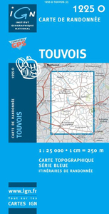
£12.99
Topographic survey of France at 1:25, 000 in IGN`s excellent TOP25 / Série Bleue series. All the maps are GPS compatible, with a 1km UTM grid plus latitude & longitude lines at 5’ intervals. Contours are at 5m intervals except for mountainous areas where the maps have contours at 10m intervals, vividly enhanced by hill shading & graphics for rocky terrain. Colouring with graphics indicates different types of vegetation or land use (deciduous or coniferous forests, moors, orchards, vineyards, etc). PLEASE NOTE: coverage of France at this scale is currently being revised – the format & the presentation of each title are indicated by the letters at the end of its Sheet Reference number (e.g. 0416ET, 3531ETR, 1923SB, etc.)MAPS WITH FULL TOURIST OVERPRINT & AN ENGLISH MAP LEGEND: all TOP25 maps & the SB editions of Série Bleue have an overprint highlighting waymarked walking trails including long-distance GR routes &, where appropriate, ski routes. Symbols indicate campsites, gîtes d’etape, refuges, equestrian centres & other recreational facilities or sites, tourist information centres, cultural heritage, etc. Towns & locations of particular interest are highlighted.- ET or OT = single-sided TOP25 map covering approx. 29x 21 km / 18x 13 miles.- ETR or OTR = waterproof & tear resistant TOP25 map covering the same area as the corresponding ET or OT number, but double-sided, printed on a smaller size sheet with a good overlap between the sides.- SB = Série Bleue map with full tourist overprint; these maps, first introduced in summer 2014, each cover approx. 29x 24km / 18x 15 miles.SÉRIE BLEUE maps with numbers ending in E (Est) or O (Ouest): most editions now indicate the GR routes, but do not show any other tourist information. Map legend is in French only. Each map covers approx. 14x 20km / 9x 12 miles. ...
Archived Product
£7.50
Tours & its Environs in a series of detailed road maps at 1:80, 000 from the IGN, designed to highlight places of interest & recreational possibilities, with a city centre street plan & an enlargement of a selected hiking area. Cartography is an enlargement from 1:100, 000 to 1:80, 000 of the publisher’s highly popular TOP100 series, with very detailed presentation of the road network, including classification of local roads according to lanes, rest areas, access restrictions, etc. Railway lines are shown with stations. Topography is shown by relief shading, with spot heights & colouring for woodlands, vineyards, orchards, etc. Cycle tracks & long-distance GR routes are marked. A wide range of symbols indicate various places of interest & recreational facilities, historical & cultural sites, golf courses, rock climbing, nature reserves, etc. Refuges & gîtes d’etape are marked, but no campsites. The maps have no geographical coordinates for GPS. Each title has an index of communes. Map legend

Includes::
English.A special feature of this series is the inclusion of a large city centre street plan & an enlargement of a particularly interesting recreational area. Presentation of these features varies, so please check the individual descriptions for more information.* IN THIS TITLE: a large street plan of Tour’s city centre highlighting main traffic arteries & indicating one way streets. An additional panel presents an extract from IGN’s topographic coverage of the Rivarennes – Château de la Chatonnière area in their TOP25 series but shown here at 1:30, 000. The extract highlights local hiking routes. The map also indicates how its whole area is covered by IGN’s topographic survey at 1:25, 000.

...
Archived Product
£7.50
Street plan of Tours at 1:12, 500 from the Institut Géographique National, the country’s national survey organization, with an enlargement showing the town centre in greater detail, plus a diagram of the transport network.IGN street plans include outer suburbs &, where appropriate, adjoining localities forming part of the urban agglomeration. The plans prominently highlight principal traffic arteries & show one way streets, car parks & pedestrian zones. Latest editions also indicate 24h petrol stations & streets with separate cycle paths. Many streets are annotated with selected house for easier identification of addresses. Important public buildings are named & symbols mark locations of tourist information centres & other facilities. Street index, arranged by an administrative area, is next to the map. Map legend

Includes::
English.PLEASE NOTE: to see the list of IGN street plans of French towns & cities please click on the series link – the series description also

Includes::
a comparison between IGN & Blay-Foldex street plans.


...
Archived Product
£8.99
Tout Sweet is Karen Wheeler’s tale of how she hung up her high heels & headed for a new life in France. In her mid-thirties Karen Wheeler, fashion editor for the Mail on Sunday, seemed to have it all, but the end of a relationship was her cue for a rain check on life. She decided to wave goodbye to the glamorous city lifestyle & the array of gorgeous shoes that went with it, & to go it alone in a run down house in rural Poitou-Charentes, in central western France. Acquiring a host of new friends & unsuitable suitors, Karen discovers that true happiness can be found in the simplest of things. ...
Archived Product
£8.99
There is so much to look forward to in the months ahead
- to lengthening evenings, bike rides past fields of sunflowers or wild
...
Archived Product
£12.99
Now in paperback, a beautifully illustrated account of of Tove Jansson`s life & art The definitive biography of one of the most unique & beloved children`s authors of the 20th century, the creator of the Moomins. Tove Jansson (1914-2001) led a long, colourful & productive life, impacting significantly the political, social & cultural history of 20th-century Finl&. & while millions of children have grown up with Little My, Snufkin, Moomintroll & the many creatures of Moominvalley, the life of Jansson
- daughter, friend & companion
- is more touching still. This book weaves together the myriad qualities of a painter, author, illustrator, scriptwriter & lyricist from fraught beginnings through fame, war & heartbreak & ultimately to a peaceful end. Dr Tuula Karjalainen is a Finnish art historian & non-fiction writer who has previously worked as a director of the Helsinki Art Museum & the Museum of Contemporary Art Kiasma in Helsinki. As the author of Tove Jansson`s biography, Karjalainen has become an expert not only on Jansson`s writing & art but also on her decades of personal correspondence & journals.

...
Archived Product
£3.50
Tow Law in 1897 in a fascinating series of reproductions of old Ordnance Survey plans in the Alan Godfrey Editions, ideal for anyone interested in the history of their neighbourhood or family. Tow Law stands over 1, 000 feet up & developed in the mid 19th century with the growth of the Weardale Iron Co; the iron works closed in the 1880s, local ore being too expensive to extract. However, this is still a busy map with several collieries & railways. Features include the town itself, with cattle market, Dan`s Castle, Tow Law Iron Works (a smaller works run by Joseph Bond), station, St Philip & St James church, South Cornsay, Black Prince Colliery, etc. Further east the map

Includes::
West Thornley Colliery, Hedleyhope Colliery & the NER`s Hedleyhope Incline. On the reverse is a small extract of adjacent sheet 25.10 extending coverage to Inkerman, plus a directory. About the Alan Godfrey Editions of the 25” OS Series: Selected towns in Great Britain & Ireland are covered by maps showing the extent of urban development in the last decades of the 19th & early 20th century. The plans have been taken from the Ordnance Survey mapping & reprinted at about 15 inches to one mile (1:4, 340). On the reverse most maps have historical notes & many also include extracts from contemporary directories. Most maps cover about one mile (1.6kms) north/south, one & a half miles (2.4kms) across; adjoining sheets can be combined to provide wider coverage.FOR MORE INFORMATION & A COMPLETE LIST OF ALL AVAILABLE TITLES PLEASE CLICK ON THE SERIES LINK.

...
Archived Product
£14.99
Pluck has been driving all over town in his little red tow truck, looking for a home. When he finds out there`s a room going free in the Pill Building he goes straight there & moves in. Right away he makes lots of friends, including Zaza the cockroach & Dolly the pigeon. Now his adventures can begin... Blending realistic characters with the fantastic, full of adventure & humour, Tow-Truck Pluck is an unforgettably offbeat children`s classic in the vein of Roald Dahl`s The BFG, & one of the Netherlands most popular children`s books of all time. ...
Archived Product
£8.99
A deeply rewarding & beautiful novel` Hilary Mantel, Guardian Life in England seems transitory for Grace Cleave as the pull of her native New Zealand grows stronger. She begins to feel increasingly like a migratory bird. Grace longs to find her own place in the world, if only she can decide where that is. But first she must learn to feel comfortable in her own skin, feathers & all. Written in 1963, Janet Frame considered this novel too personal to be published in her lifetime. ` In this deeply personal novel of exile & loneliness, Janet Frame proves the master of nostalgia, beauty & loss. Frame is, & will remain, divine` Alice Sebold ` Exceptional.. .comic, melancholy & piercingly observant` Sunday Telegraph ...
Archived Product
£8.99
After many generations, it is now Harold who runs Ard Farm. Out on the fells, he feels his father`s presence, & there is hope that he, his grandmother & his Uncle Joe will be able to take the farm forward & prosper. But their way of life is under threat: farming is undergoing huge change & increasingly harmful intervention. Towards Mellbreak is a hymn both to the landscape of Cumbria & to a disappearing world. Poetic, beautiful & tragic, it exposes the struggle to preserve traditions & beliefs in the face of change, & an assertion of the power to be found in the rituals we pass down through our families. ...
Archived Product

Touvois

Topographic survey of France at 1:25, 000 in IGN`s excellent TOP25 / Série Bleue series. All the maps are GPS compatible, with a 1km UTM grid plus latitude and longitude lines at 5’ intervals. Contours are at 5m intervals except for mountainous areas where the maps have contours at 10m intervals, vividly enhanced by hill shading and graphics for rocky terrain. Colouring with graphics indicates different types of vegetation or land use (deciduous or coniferous forests, moors, orchards, vineyards, etc). PLEASE NOTE: coverage of France at this scale is currently being revised – the format and the presentation of each title are indicated by the letters at the end of its Sheet Reference number (e.g. 0416ET, 3531ETR, 1923SB, etc.)MAPS WITH FULL TOURIST OVERPRINT & AN ENGLISH MAP
LEGEND: all TOP25 maps and the SB editions of Série Bleue have an overprint highlighting waymarked walking trails including long-distance GR routes and, where appropriate, ski routes. Symbols indicate campsites, gîtes d’etape, refuges, equestrian centres and other recreational facilities or sites, tourist information centres, cultural heritage, etc. Towns and locations of particular interest are highlighted.- ET or OT = single-sided TOP25 map covering approx. 29x21 km / 18x13 miles.- ETR or OTR = waterproof and tear resistant TOP25 map covering the same area as the corresponding ET or OT number, but double-sided, printed on a smaller size sheet with a good overlap between the sides.- SB = Série Bleue map with full tourist overprint; these maps, first introduced in summer
2014, each cover approx. 29x24km / 18x15 miles.SÉRIE BLEUE maps with numbers ending in E (Est) or O (Ouest): most editions now indicate the GR routes, but do not show any other tourist information. Map legend is in French only. Each map covers approx. 14x20km / 9x12 miles.
RIP - This product is no longer available on our network. It was last seen on 25.09.2019

This page now acts as a permanent archive for this product. Add more information using the comments box below to ensure it can still be found by future generations.

Use our search facility to see if it is available from an alternative contributor.
  • Availability: Out Of Stock
  • Supplier: Stanfords
  • SKU: 9782758508342
Availability: In Stock
£11.50

Product Description

Topographic survey of France at 1:25, 000 in IGN`s excellent TOP25 / Série Bleue series. All the maps are GPS compatible, with a 1km UTM grid plus latitude & longitude lines at 5’ intervals. Contours are at 5m intervals except for mountainous areas where the maps have contours at 10m intervals, vividly enhanced by hill shading & graphics for rocky terrain. Colouring with graphics indicates different types of vegetation or land use (deciduous or coniferous forests, moors, orchards, vineyards, etc). PLEASE NOTE: coverage of France at this scale is currently being revised – the format & the presentation of each title are indicated by the letters at the end of its Sheet Reference number (e.g. 0416ET, 3531ETR, 1923SB, etc.)MAPS WITH FULL TOURIST OVERPRINT & AN ENGLISH MAP LEGEND: all TOP25 maps & the SB editions of Série Bleue have an overprint highlighting waymarked walking trails including long-distance GR routes &, where appropriate, ski routes. Symbols indicate campsites, gîtes d’etape, refuges, equestrian centres & other recreational facilities or sites, tourist information centres, cultural heritage, etc. Towns & locations of particular interest are highlighted.- ET or OT = single-sided TOP25 map covering approx. 29x 21 km / 18x 13 miles.- ETR or OTR = waterproof & tear resistant TOP25 map covering the same area as the corresponding ET or OT number, but double-sided, printed on a smaller size sheet with a good overlap between the sides.- SB = Série Bleue map with full tourist overprint; these maps, first introduced in summer 2014, each cover approx. 29x 24km / 18x 15 miles.SÉRIE BLEUE maps with numbers ending in E (Est) or O (Ouest): most editions now indicate the GR routes, but do not show any other tourist information. Map legend is in French only. Each map covers approx. 14x 20km / 9x 12 miles.

Reviews/Comments

Add New

Intelligent Comparison

Oooops!
We couldn't find anything!
Perhaps this product's unique.... Or perhaps we are still looking for comparisons!
Click to bump this page and we'll hurry up.

Price History

Vouchers

No voucher codes found.
Do you know a voucher code for this product or supplier? Add it to Insights for others to use.

Facebook

Jargon Buster

GPS - Global Positioning System - Global position using satellites
Summer - The season between Spring and Autumn. Usually the hottest season of the year
France - A state situated in Western Europe with several overseas territories.
Graphics - A general term for visual aspects of an item/display
Waterproof - Resistant to water, usualy specified by depth in metres
Size - is the measurement of how big an object is in space.
Km - Kilometre. A unit of measurement equal to 1000 metres.
Resistant - Something that can repel against something.
Reference - To prove evidence with a back up source.

Supplier Information

Stanfords
Stanfords was established in 1853 and opened their iconic Covent Garden flagship store in 1901. They have become the top retailer of maps, travel books and accessories in the UK and arguably offer the largest selection of maps and travel books worldwide. Famous names such as Captain Robert Falcon Scott, Ranulph Fiennes and Michael Palin have purchased from Stanfords. They now have a shop in Bristol and both stores together with other venues operate a calendar of events including talks, book signings and exhibitions. As a specialist map retailer, the map selection is comprehensive and includes road maps, street maps and walking maps from worldwide destinations, as well as a selection of world atlases and wall maps. Books include travel guides and travel literature. Stanfords also stock globes, from miniatures made of blue marble to magnificent floor-standing globes. The website features a selection of interesting articles on travel topics.
Page Updated: 2023-11-12 20:15:36

Community Generated Product Tags

Oh No! The productWIKI community hasn't generated any tags for this product yet!
Menu