More From Contributor
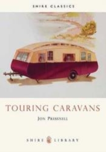
£8.99
Wine map of the Touraine region in IGN’s series covering the main wine growing areas of France on colourful & informative maps, showing each area’s road network with locations of individual vineyards, etc. The map covers vineyards along the Loire from the environs of Blois to its confluence with the Vienne, as well as along the upper reaches of the Vienne & the Cher, plus valley of the Loir west of Vendôme. Two small insets show the outlaying areas around Razines & Bossay-sur-Claise. Map legend

Includes::
English.

...
Archived Product
£17.99
Wall map of the Touraine wine region in IGN’s series covering the main wine growing areas of France. The map is *encapsulated*, so it is damp-proof & will not crinkle in humid conditions. It can be written on with suitable marker pens. Encapsulation gives the map a shiny surface, similar to being displayed behind glass. The map covers vineyards along the Loire from the environs of Blois to its confluence with the Vienne, as well as along the upper reaches of the Vienne & the Cher, plus valley of the Loir west of Vendôme. Two small insets show the outlaying areas around Razines & Bossay-sur-Claise. Map legend

Includes::
English.

...
Archived Product
£17.99
Topographic survey of Portugal at 1:50, 000 from the Instituto Geográfico do Exército, the country’s military survey organisation. The maps have contours at 20m intervals & in addition to the standard features shown on topographic mapping at this scale also indicate various types of terrain or vegetation (s&, terraces, rocks, woodlands, vineyards, etc). Each sheet covers an area of 32 x 20km (20 x 12.5 miles approx). The maps have a 1-km UTM grid plus latitude & longitude coordinates for the map corners. Map legend & a glossary of terms used on the maps include English.EDITION DATES: most titles in this series date from 1990s or later. To see all the titles in this series please click on the series link. ...
Archived Product
£17.99
Topographic survey of Portugal at 1:50, 000 from the Instituto Geográfico Português, the country’s civilian survey organisation. The maps have contours at 25m intervals & in addition to the standard features shown on topographic mapping at this scale also indicate various types of vegetation (vineyards, olive groves, etc). Each sheet covers an area of 32 x 20km (20 x 12.5miles approx). The maps have latitude & longitude margin ticks at 1’ intervals & UTM coordinates for the map corners – each sheet also shows conversion details from BBLx (Bessel-Bonnie system, Datum Lisbon) to UTM. Map legend is in Portuguese only.EDITION DATES: most titles in this series have now been updated in the 1990s or later. To see all the titles in this series please click on the series link. ...
Archived Product
£17.99
Topographic survey of Portugal at 1:100, 000 from the Instituto Geográfico Português, the country’s civilian survey organisation. The maps have contours at 50m intervals & in addition to the standard features shown on topographic mapping at this scale also indicate various types of vegetation (vineyards, olive groves, etc). Each sheet covers an area of 64 x 40km (40 x 25 miles approx). The maps have latitude & longitude margin ticks at 1’ intervals, plus show UTM coordinates for the map corners. Map legend is in Portuguese only.PLEASE NOTE
- EDITION DATES: some sheets at this scale date back to the 1950s or 1960s. For more recent editions please see IGP’s 1:25, 000 series where each 50K map is divided into four quarters. To see all the titles in the 1:100, 000 series please click on the series link.
...
Archived Product
£14.99
This is a brand new re-print of the hugely popular 1930`s board game. Not only is it exciting but it is also educational. Players use their skill & judgement to reach their destination, while avoiding the hazards along the way. This edition features a replica of the original board & cards, together with four wooden `car` playing pieces. This is a great family game for 2 or more people. ...
Archived Product
£11.00
This pocket-sized guidebook takes the reader on eight walking tours to archaeological sites throughout the boroughs of New York City & presents a new way of exploring the city through the rich history that lies buried beneath it. Generously illustrated & replete with maps, the tours are designed to explore both ancient times & modern space. On these tours, readers will see where archaeologists have discovered evidence of the earliest New Yorkers, the Native Americans who arrived at least 11, 000 years ago. They will learn about thous&-year-old trading routes, sacred burial grounds, & seventeenth-century villages. They will also see sites that reveal details of the lives of colonial farmers & merchants, enslaved Africans, Revolutionary War soldiers, & nineteenth-century hotel keepers, grocers, & housewives. Some tours bring readers to popular tourist attractions (the Statue of Liberty & the Wall Street district, for example) & present them in a new light. Others center on places that even the most seasoned New Yorker has never seen-colonial houses, a working farm, out-of-the-way parks, & remote beaches-often providing beautiful & unexpected views from the city`s vast shoreline. A celebration of New York City`s past & its present, this unique book will intrigue everyone interested in the city & its history. ...
Archived Product
£5.50
This is a folded road map of Mozambique featuring: an easy-to-read road map with numbers on main routes; National parks, nature reserves & places of interest; detailed area maps of Ilha do Bazaruto, Gorongosa National Park & Inhambane; & town plans of Maputo & Beira. If you are visiting Mozambique on holiday then this map is a must for you. It is on the scale of 1:1, 200, 000. ...
Archived Product
£9.95
The guide describes the ground & operations covered by the British, French & US Expeditionary Forces deployed from France to the area north of Venice between November 1917 & Spring 1919. These forces supported the Italians after their disastrous defeat at Caporetto & helped stem the Austrian & German onslaught. This is the first guide to the Allied contribution & the Piave Defence line. The guide also covers the rear areas
- supply & repair services, training & recreation. It also describes the movement to Italy & subsequent service & care of the 16, 000 British & 20, 000 French horses & mules.
...
Archived Product
£16.99
Wild coasts, jaw-dropping cliffs & caves, tranquil bays, thermal hotspots, towering alps, primeval forests, lakes & braided rivers, offshore islands... New Zealand's natural wonders are top of anyone's must-see list. Peter Janssen's magnificent touring guide dedicated to natural attractions is structured geographically around itineraries
- 22 in the North Island & 25 in the South
- each of which takes in several sites within one area, describing their natural beauty & listing a few good short walks or detours that show off the scenery at its best. The itineraries are flexible, allowing the reader to simply follow the book or use it as back-up for more personalised touring plans. The text is supported by route instructions, detailed maps, illustrated panels on notable plants & animals, & stunning images from a leading landscape photographer.

...
Archived Product

Touring Caravans

The development of the caravan is a fascinating story, and a vital part of our motoring heritage. In this book, Jon Pressnell traces the evolution of the touring caravan from its earliest horse-drawn days through to the lightweight aerodynamically styled `designer` caravans of today. It is an absorbing tale of a cottage industry which expanded rapidly in the motoring revolution of the 1930s, as the motor car extended the horizons of the British public; a story of how the caravan evolved from a half-timbered `cottage on wheels` to the mass-produced streamlined versatile trailer which we take for granted today. This Album chronicles the process and brings alive, with the help of a selection of period photographs, the appeal of classic caravans.
RIP - This product is no longer available on our network. It was last seen on 25.09.2019

This page now acts as a permanent archive for this product. Add more information using the comments box below to ensure it can still be found by future generations.

Use our search facility to see if it is available from an alternative contributor.
  • External links may include paid for promotion
  • Availability: Out Of Stock
  • Supplier: Stanfords
  • SKU: 9780747801191
Availability: In Stock
£4.99

Product Description

The development of the caravan is a fascinating story, & a vital part of our motoring heritage. In this book, Jon Pressnell traces the evolution of the touring caravan from its earliest horse-drawn days through to the lightweight aerodynamically styled `designer` caravans of today. It is an absorbing tale of a cottage industry which expanded rapidly in the motoring revolution of the 1930s, as the motor car extended the horizons of the British public; a story of how the caravan evolved from a half-timbered `cottage on wheels` to the mass-produced streamlined versatile trailer which we take for granted today. This Album chronicles the process & brings alive, with the help of a selection of period photographs, the appeal of classic caravans.

Reviews/Comments

Add New

Intelligent Comparison

Oooops!
We couldn't find anything!
Perhaps this product's unique.... Or perhaps we are still looking for comparisons!
Click to bump this page and we'll hurry up.

Price History

Vouchers

No voucher codes found.
Do you know a voucher code for this product or supplier? Add it to Insights for others to use.

Facebook

Jargon Buster

Motor - A evice that converts electricity into motion
Car - A machine used for transport which runs on roads
Versatile - Something that can be adapted to various different tasks.
Horse - A large animal with four legs that tends to be ridden.
Versatile - Something that is able to adapt to its surroundings or its requirements.
Classic - Something that is still like it was originally a high quality standard.
Cottage - A house typically found in the country, commonly small in size.

Supplier Information

Stanfords
Stanfords was established in 1853 and opened their iconic Covent Garden flagship store in 1901. They have become the top retailer of maps, travel books and accessories in the UK and arguably offer the largest selection of maps and travel books worldwide. Famous names such as Captain Robert Falcon Scott, Ranulph Fiennes and Michael Palin have purchased from Stanfords. They now have a shop in Bristol and both stores together with other venues operate a calendar of events including talks, book signings and exhibitions. As a specialist map retailer, the map selection is comprehensive and includes road maps, street maps and walking maps from worldwide destinations, as well as a selection of world atlases and wall maps. Books include travel guides and travel literature. Stanfords also stock globes, from miniatures made of blue marble to magnificent floor-standing globes. The website features a selection of interesting articles on travel topics.
Page Updated: 2023-11-12 20:15:36

Community Generated Product Tags

Oh No! The productWIKI community hasn't generated any tags for this product yet!
Menu