More From Contributor

£8.50
Street plan of the Toulon agglomeration at 1:14, 500 with enlargements showing in greater detail several of its town centres. Coverage of this double-sided map extends west to include Six-Fours-les-Plages & Sanary-sur-Mer, & eastwards to show La Valette-du-Var, La Garde & Le Pradet. The enlargement for Toulon’s historic centre & its adjoining area including the railway station is conveniently placed on the cover of the accompanying index booklet, whilst on both sides of the map are additional panels with enlargements of the areas to the west & south-east of the Toulon’s city centre plan, plus enlargements for the centres of La Seyne-sur-Mer, La Garde, La Valette-du-Var, Sanary-sur-Mer & Ollioules, Blay plans include outer suburbs &, where appropriate, adjoining localities forming part of the urban agglomeration & provide brief descriptions of the town’s main sights, contact details for hotels & other places of interest, etc. The plans show one way streets, car parks & pedestrian zones. Important public buildings are clearly marked & identified. Blay street maps are usually double-sided & include an enlargement for the town centre & a street index with separate lists of “edifices publics”: main public buildings, places of worship, schools, sport facilities, stations, etc. Each of the outer suburbs or the adjoining localities, identified with its postcode, has a separate index. Many titles also provide a road map of the environs. All the text is in French only.PLEASE NOTE: to see the list of Blay-Foldex street plans of French towns & cities please click on the series link – the series description also

Includes::
a comparison between Blay & IGN street plans.

...
Archived Product
£12.99
Topographic survey of France at 1:25, 000 in IGN`s excellent TOP25 / Série Bleue series. All the maps are GPS compatible, with a 1km UTM grid plus latitude & longitude lines at 5’ intervals. Contours are at 5m intervals except for mountainous areas where the maps have contours at 10m intervals, vividly enhanced by hill shading & graphics for rocky terrain. Colouring with graphics indicates different types of vegetation or land use (deciduous or coniferous forests, moors, orchards, vineyards, etc). PLEASE NOTE: coverage of France at this scale is currently being revised – the format & the presentation of each title are indicated by the letters at the end of its Sheet Reference number (e.g. 0416ET, 3531ETR, 1923SB, etc.)MAPS WITH FULL TOURIST OVERPRINT & AN ENGLISH MAP LEGEND: all TOP25 maps & the SB editions of Série Bleue have an overprint highlighting waymarked walking trails including long-distance GR routes &, where appropriate, ski routes. Symbols indicate campsites, gîtes d’etape, refuges, equestrian centres & other recreational facilities or sites, tourist information centres, cultural heritage, etc. Towns & locations of particular interest are highlighted.- ET or OT = single-sided TOP25 map covering approx. 29x 21 km / 18x 13 miles.- ETR or OTR = waterproof & tear resistant TOP25 map covering the same area as the corresponding ET or OT number, but double-sided, printed on a smaller size sheet with a good overlap between the sides.- SB = Série Bleue map with full tourist overprint; these maps, first introduced in summer 2014, each cover approx. 29x 24km / 18x 15 miles.SÉRIE BLEUE maps with numbers ending in E (Est) or O (Ouest): most editions now indicate the GR routes, but do not show any other tourist information. Map legend is in French only. Each map covers approx. 14x 20km / 9x 12 miles. ...
Archived Product
£160.00
Toulon, an original antique map by S.D.U.K., published in London, 1844. Steel plate, uncoloured. Map size 38 x 30 cm, overall mounted size 53.5 x 47 cm.A detailed map of Toulon published by the Society for the Diffusion of Useful Knowledge. The Society was founded by John, Earl Russell, & Henry Brougham, later Lord Chancellor of England in 1827. The Society's main purpose was to encourage universal literacy by publishing numbers of books of good quality that would be affordable to all. These town plans were published in perhaps the grandest of the Society's publications
- their atlas entitled Maps Of The Society For The Diffusion Of Useful Knowledge, first issued by Baldwin & Cradock, & then re-issued by other publishers, including Chapman & Hall & latterly Edward Stanford. The map

Includes::
a vignette panoramic view of Toulon from the outworks on the east. The map was engraved by B.R. Davies after W.B. Clarke. Antique maps from various original publishers are presented on the Stanford


...
Archived Product
£7.50
Toulon & its Environs in a series of detailed road maps at 1:80, 000 from the IGN, designed to highlight places of interest & recreational possibilities, with a city centre street plan & an enlargement of a selected hiking in area. Coverage extends north beyond the A8 autoroute &

Includes::
St-Maximin-la Ste- Baule, Brignoles & Lorgues. Along the coast the map extends west to Bandol & eastwards to Le Lavandou, Ile de Porquerolles & Ile de Port Cros (ferry connections to the islands are marked). Cartography is an enlargement from 1:100, 000 to 1:80, 000 of the publisher’s highly popular TOP100 series, with very detailed presentation of the road network, including classification of local roads according to lanes, rest areas, access restrictions, etc. Railway lines are shown with stations. Topography is shown by relief shading, with spot heights & colouring for woodlands, vineyards, orchards, etc. Cycle tracks & long-distance GR routes are marked. A wide range of symbols indicate various places of interest & recreational facilities, historical & cultural sites, golf courses, rock climbing, nature reserves, etc. Refuges & gîtes d’etape are marked, but no campsites. The maps have no geographical coordinates for GPS. Each title has an index of communes. Map legend

Includes::
English.A special feature of this series is the inclusion of a large city centre street plan & an enlargement of a particularly interesting recreational area. Presentation of these features varies, so please check the individual descriptions for more information.* IN THIS TITLE: a street plan of central Toulon highlighting main traffic arteries & indicating one way streets. An additional panel presents an extract from IGN’s topographic coverage of the Mont Faron area, shown here at 1:30, 000 & highlighting local hiking trails. The map also indicates how its whole area is covered by IGN’s topographic survey at 1:25, 000.


...
Archived Product
£8.50
Street plan of the Toulouse agglomeration at 1:15, 000 with an enlargement showing the town centre in greater detail, plus in a separate booklet a diagram of the city’s public transport network (metro, tram, bus), street index, information on sights & hotels, etc. Both the main plan & the enlargement show location of the Vélô Toulouse bicycle rental stations. This title is part of an extensive series of street plans of French towns from Blay-Foldex, the country’s largest, oldest & most experienced publisher of urban mapping. Blay plans include outer suburbs &, where appropriate, adjoining localities forming part of the urban agglomeration & provide brief descriptions of the town’s main sights, contact details for hotels & other places of interest, etc. The plans show one way streets, car parks & pedestrian zones. Important public buildings are clearly marked & identified. Blay street maps are usually double-sided & include an enlargement for the town centre & a street index with separate lists of “edifices publics”: main public buildings, places of worship, schools, sport facilities, stations, etc. Each of the outer suburbs or the adjoining localities, identified with its postcode, has a separate index. Many titles also provide a road map of the environs. All the text is in French only.PLEASE NOTE: to see the list of Blay-Foldex street plans of French towns & cities please click on the series link – the series description also

Includes::
a comparison between Blay & IGN street plans.

...
Archived Product
£7.50
Toulouse & its Environs in a series of detailed road maps at 1:80, 000 from the IGN, designed to highlight places of interest & recreational possibilities, with a city centre street plan & an enlargement of a selected hiking area. Cartography is an enlargement from 1:100, 000 to 1:80, 000 of the publisher’s highly popular TOP100 series, with very detailed presentation of the road network, including classification of local roads according to lanes, rest areas, access restrictions, etc. Railway lines are shown with stations. Topography is shown by relief shading, with spot heights & colouring for woodlands, vineyards, orchards, etc. Cycle tracks & long-distance GR routes are marked. A wide range of symbols indicate various places of interest & recreational facilities, historical & cultural sites, golf courses, rock climbing, nature reserves, etc. Refuges & gîtes d’etape are marked, but no campsites. The maps have no geographical coordinates for GPS. Each title has an index of communes. Map legend

Includes::
English.A special feature of this series is the inclusion of a large city centre street plan & an enlargement of a particularly interesting recreational area. Presentation of these features varies, so please check the individual descriptions for more information.* IN THIS TITLE: a street plan of central Toulouse highlighting main traffic arteries & indicating one way streets. An additional panel presents an extract from IGN’s topographic coverage of the Forêt de Bouconne area, shown here at 1:30, 000. The map also indicates how its whole area is covered by IGN’s topographic survey at 1:25, 000.

...
Archived Product
£5.99
Toulouse & the surrounding area presented by Michelin at 1:150, 000, with city maps of central Toulouse, Carcassonne, Albi & Agen. Coverage extends north-west to Agen, west to Auch & St. Gaudens, south to Foix, & east to Carcassonne. Locations worth visiting are prominently highlighted & have star rating. The map has latitude & longitude lines at 10’ intervals & is indexed. Accompanying city maps have indexes of main streets, with Carcassonne presented on separate plans of its Ville Basse & the fortress of La Cité. Michelin Zoom series of France covers popular holiday areas with Michelin’s road mapping either adapted to provide more convenient coverage or enlarged for greater clarity. Presentation of the road network

Includes::
scenic routes & viewpoints, classification according to the number of lanes, motorway junctions indicating full or partial interchanges, motorway services & rest areas, gradients, limited height & load, entry restrictions, etc. Railway lines are included. Small symbols mark various places of interest & in the more recently published titles towns, villages & areas of particular interest are allocated star rating. Unless specified to the contrary in the individual description, the maps are indexed. All the titles have an English language map legend. To see the list of titles in this series please click on the series link.

...
Archived Product
£12.99
Topographic survey of France at 1:25, 000 in IGN`s excellent TOP25 / Série Bleue series. All the maps are GPS compatible, with a 1km UTM grid plus latitude & longitude lines at 5’ intervals. Contours are at 5m intervals except for mountainous areas where the maps have contours at 10m intervals, vividly enhanced by hill shading & graphics for rocky terrain. Colouring with graphics indicates different types of vegetation or land use (deciduous or coniferous forests, moors, orchards, vineyards, etc). PLEASE NOTE: coverage of France at this scale is currently being revised – the format & the presentation of each title are indicated by the letters at the end of its Sheet Reference number (e.g. 0416ET, 3531ETR, 1923SB, etc.)MAPS WITH FULL TOURIST OVERPRINT & AN ENGLISH MAP LEGEND: all TOP25 maps & the SB editions of Série Bleue have an overprint highlighting waymarked walking trails including long-distance GR routes &, where appropriate, ski routes. Symbols indicate campsites, gîtes d’etape, refuges, equestrian centres & other recreational facilities or sites, tourist information centres, cultural heritage, etc. Towns & locations of particular interest are highlighted.- ET or OT = single-sided TOP25 map covering approx. 29x 21 km / 18x 13 miles.- ETR or OTR = waterproof & tear resistant TOP25 map covering the same area as the corresponding ET or OT number, but double-sided, printed on a smaller size sheet with a good overlap between the sides.- SB = Série Bleue map with full tourist overprint; these maps, first introduced in summer 2014, each cover approx. 29x 24km / 18x 15 miles.SÉRIE BLEUE maps with numbers ending in E (Est) or O (Ouest): most editions now indicate the GR routes, but do not show any other tourist information. Map legend is in French only. Each map covers approx. 14x 20km / 9x 12 miles. ...
Archived Product
£19.99
The first book to cover in detail every major climb ever used in the Tour de France, including detail on the actual route (with maps & profile), length, height, list of winners & route descriptions of how to emulate the King of the Mountains & get from the bottom to the top. Every year the Tour de France is said to only really start when it reaches the first mountain stages: the drama of the race only really begins as the climbers take over in the Pyrenees, Vosges or Alps. The Tour is also the most famous classic in cycling & draws huge audiences to the TV & internet coverage (the official web site holds the world record for number of hits excluding search engines). But the route of the Tour is not just for professionals. A growing number of people now take their bikes & actually do a stage of the Tour (the Etap
- for amateurs, which this year attracted 8, 000 people to climb one of the hardest mountain stages in the Tour) or spend a week doing some of the more notorious climbs (Ventoux
- where Tommy Simpson died in the 50s). This book is for everyone who watches the Tour & has even the slightest of an inkling that they'd like to do at least one of the climbs. Packed with information on each climb, this is the ultimate guide to the Tour climbs, which will remain important for many years to come (the Tour only uses a set number of climbs, which they return to every couple of years). Contents
- Eastern Pyrenees, Central Pyrenees, Western Pyrenees, Vosges & Jura, Massif & Cevennes, Northern Alps, Central Alps & Southern Alps


...
Archived Product
£20.50
GRP: Tour de Beaufortain, FFRP topo-guide ref. no. 731, one of the titles from an extensive series of light, high quality, A5 paperback guides to the Sentiers de Grande Randonnée, the GR routes, a dense network of long-distance footpaths across the French countryside. Each topo-guide covers either a circular route, or part of a longer path. Supporting the descriptions are *colour extracts from IGN`s 1:50, 000 or 1:25, 000 topographic surveys overprinted with the route*. The text is in French, but a large amount of information is conveyed by symbols. A list of all the main places along the route indicates what facilities can be found there: public transport, food shops, & various types of accommodation, with addresses & telephone numbers.* In this guide:* the 140-km Tour du Beaufortain, south of Mont Blanc, plus variants. ...
Archived Product

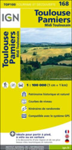
Toulouse - Pamiers - St Gaudens IGN Top100 Map 168

Map No. 168, Toulouse - Pamiers, at 1:100, 000, part of the TOP100 series from the Institut Géographique National (IGN). These exceptionally detailed, contoured and GPS compatible road maps which include English language map legend are ideal for exploring the French countryside by car, by bike, or even on foot. Used by millions of locals and tourists alike, this series provides an excellent balance between coverage of a sufficiently wide area and detailed road presentation, plus topographic information not found on other road maps of France. For several decades now these maps, previously known as Série Verte, have been one of Stanfords’ leading bestsellers.PLEASE NOTE: to see the full specifications of the cartography (contour interval, GPS compatibility, etc) and the list
of all the titles in this series please click on the series link.This title is (as shown on our coverage image) centred on Toulouse and coverage includes Fleurance, Beaumont-de-Lomagne, Mauvezin, Gimont, L’Isle-Jourdain, Verdun-sure-Garonne, Grisolles, Villemur-sur-Tarn, Rabatens, Lisle-sur-Tarn, Gaillac, Albi in its north-eastern corner, Lavaur, Graulhet, Verfeil, Puylaurens, Revel, Castelnaudary, Bram, Villefranche-sur-Lauragais, Auterive, Pamiers, Mazères, Lézet-sur-Lèze, Montesquieu-Volvestre, Rieux, Cazères, Martres-Tolosane, Salies-du-Salat and St-Gaudens in its south-western corner.
RIP - This product is no longer available on our network. It was last seen on 25.09.2019

This page now acts as a permanent archive for this product. Add more information using the comments box below to ensure it can still be found by future generations.

Use our search facility to see if it is available from an alternative contributor.
  • Availability: Out Of Stock
  • Supplier: Stanfords
  • SKU: 9782758527008
Availability: In Stock
£8.99

Product Description

Map No. 168, Toulouse
- Pamiers, at 1:100, 000, part of the TOP100 series from the Institut Géographique National (IGN). These exceptionally detailed, contoured & GPS compatible road maps which include English language map legend are ideal for exploring the French countryside by car, by bike, or even on foot. Used by millions of locals & tourists alike, this series provides an excellent balance between coverage of a sufficiently wide area & detailed road presentation, plus topographic information not found on other road maps of France. For several decades now these maps, previously known as Série Verte, have been one of Stanfords’ leading bestsellers.PLEASE NOTE: to see the full specifications of the cartography (contour interval, GPS compatibility, etc) & the list of all the titles in this series please click on the series link. This title is (as shown on our coverage image) centred on Toulouse & coverage

Includes::
Fleurance, Beaumont-de-Lomagne, Mauvezin, Gimont, L’ Isle-Jourdain, Verdun-sure-Garonne, Grisolles, Villemur-sur-Tarn, Rabatens, Lisle-sur-Tarn, Gaillac, Albi in its north-eastern corner, Lavaur, Graulhet, Verfeil, Puylaurens, Revel, Castelnaudary, Bram, Villefranche-sur-Lauragais, Auterive, Pamiers, Mazères, Lézet-sur-Lèze, Montesquieu-Volvestre, Rieux, Cazères, Martres-Tolosane, Salies-du-Salat & St-Gaudens in its south-western corner.

Reviews/Comments

Add New

Intelligent Comparison

Oooops!
We couldn't find anything!
Perhaps this product's unique.... Or perhaps we are still looking for comparisons!
Click to bump this page and we'll hurry up.

Price History

Vouchers

No voucher codes found.
Do you know a voucher code for this product or supplier? Add it to Insights for others to use.

Facebook

Jargon Buster

GPS - Global Positioning System - Global position using satellites
Foot - A part of the body at the bottom end of the leg
Foot - or Feet - a measurement equivilent to 30cm
France - A state situated in Western Europe with several overseas territories.
Car - A machine used for transport which runs on roads
Language - the method of communication used in different areas. Humans and computers have many different languages.
Road - a manmade lane or a path that is used to speed up travel.
Wide - Something with a large width.
Balance - Something that is evenly weighted to keep something upright.
Toulouse - A city on the south of France.
Ideal - Something that satisfies a perfect criteria.
Language - The way humans communicate either written and spoken.

Supplier Information

Stanfords
Stanfords was established in 1853 and opened their iconic Covent Garden flagship store in 1901. They have become the top retailer of maps, travel books and accessories in the UK and arguably offer the largest selection of maps and travel books worldwide. Famous names such as Captain Robert Falcon Scott, Ranulph Fiennes and Michael Palin have purchased from Stanfords. They now have a shop in Bristol and both stores together with other venues operate a calendar of events including talks, book signings and exhibitions. As a specialist map retailer, the map selection is comprehensive and includes road maps, street maps and walking maps from worldwide destinations, as well as a selection of world atlases and wall maps. Books include travel guides and travel literature. Stanfords also stock globes, from miniatures made of blue marble to magnificent floor-standing globes. The website features a selection of interesting articles on travel topics.
Page Updated: 2023-11-12 20:15:36

Community Generated Product Tags

Oh No! The productWIKI community hasn't generated any tags for this product yet!
Menu