
 United Kingdom
 France
 Germany
 Netherlands
 Sweden
 USA
USA
 Italy
Italy
 Spain
Spain
More From Contributor

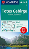


Totes Gebirge West Alpenverein KOMBI Map 15/1
Totes Gebirge West area of the Alps in a combined hiking and ski edition at 1:25, 000 from a series of detailed, GPS compatible maps published by the DAV - Deutscher Alpenverein and produced by the German and Austrian Alpine Clubs using cartography from their respective survey organizations. Maps in this series have topography vividly presented by contours at 20 metres intervals, enhanced by shading and finely drawn graphic relief. An overprint highlights hiking paths and/or ski routes (please see the note below), campsites and various types of mountain huts and refuges. The area covered by each map varies according to the scale; for 1:25, 000 maps it is approximately 25x18 km (15 x 11 miles). The maps have a 1-km UTM grid, plus margin ticks with latitude and longitude at intervals of
1`. Map legend is in German only.PLEASE NOTE – THE OVERPRINT FOR HIKING and/or SKI ROUTES: all Sheet Ref. numbers shown on the accompanying grid are available with an overprint highlighting hiking trails, indicating sections with fixed climbing ropes and, where appropriate, the waymarking route numbers. Several titles are now published with both hiking and ski routes on them. Other areas are covered by two separate maps: a hiking edition plus a ski edition. The type of the overprint is indicated in our title of each map.To see the list of titles in this series please click on the series link.
1`. Map legend is in German only.PLEASE NOTE – THE OVERPRINT FOR HIKING and/or SKI ROUTES: all Sheet Ref. numbers shown on the accompanying grid are available with an overprint highlighting hiking trails, indicating sections with fixed climbing ropes and, where appropriate, the waymarking route numbers. Several titles are now published with both hiking and ski routes on them. Other areas are covered by two separate maps: a hiking edition plus a ski edition. The type of the overprint is indicated in our title of each map.To see the list of titles in this series please click on the series link.

Product Description
Reviews/Comments
Add New
Intelligent Comparison
Archived Product

Totes Gebirge East Alpenverein KOMBI Map 15/3 Stanfords
£11.99
Archived Product

Totes Gebirge Central Alpenverein KOMBI Map 15/2 Stanfords
£11.99
Archived Product

Karwendelgebirge West Alpenverein Map 5/1 Stanfords
£11.99
Archived Product

Steinernes Meer Alpenverein KOMBI Map 10/1 Stanfords
£11.99
Archived Product

Kaisergebirge Alpenverein KOMBI Map 8 Stanfords
£11.99
Vouchers
No voucher codes found.
Do you know a voucher code for this product or supplier? Add it to Insights for others to use.
Do you know a voucher code for this product or supplier? Add it to Insights for others to use.
 Denmark