More From Contributor

£7.99
Toledo, including a detailed enlargements of its Old Town highlighting historic sights & four special routes with English language descriptions, on an indexed street plan from Telstar Distrimapas, Spain’s leading publisher of city maps. On one side is an indexed street plan of the whole city at 1:6, 650 with a separate inset extending it to include Santa Maria de Benquerencia at 1:7, 000. The plan indicates access to the city, its main traffic arteries & names individual districts as well as various public buildings. On the reverse is a very detailed plan at 1:3, 100 of the city’s historic heart with many of its famous buildings highlighted by drawings. Four special sightseeing routes: the Jewish quarter, squares & markets, convents & covered passages, plus the Mudéjar quarters are indicated on the plan & provided with bilingual Spanish & English descriptions. The plan has a separate street index & suggestions for two more car routes are provided covering various sights outside the city & the famous view of Toledo from the hills across the Tajo. ...
Archived Product
£8.75
Glossy English language guide to Toledo (Spain) from Editorial Everest, focusing on the cultural rather than the practical aspects of a trip. What the guide lacks in information on things like restaurants & accommodation, it more than makes up for with full-colour photographs & in-depth looks at the history of areas of Toledo, as well as the impacts this has had on modern culture, with a short section included on Living in Toledo. Recommended as a supplement to either a map or a more-detailed practical guide. ...
Archived Product
£9.95
Contoured, GPS-compatible, indexed road map at 1:200, 000 from CNIG
- Spain’s civilian survey organization, with exceptionally
...
Archived Product
£6.50
Toledo & its environs at 1:125, 000 on a special sheet from the Spanish topographic survey published by the Instituto Geográfico Nacional, plus a street plan on the reverse with four walks & 34 places of interest. On one side is a special sheet from Spain’s civilian topographic survey at 1:25, 000 covering the city & its environs. The map has contours at 10m intervals, colouring & graphics to show different types of vegetation & all other information expected of topographic mapping at such detailed scale. The map has a 1km UTM grid, plus margin ticks at 1’. On the reverse is a large street plan of Toledo’s historic city centre highlighting four special sightseeing itineraries & 34 historic buildings. Map legend is in Spanish only. ...
Archived Product
£6.50
Toledo in Ohio on an indexed street plan from Rand Mc Nally in their extensive range of maps covering cities in the United States. An inset provides a road map of Toledo & vicinity. Communities covered by this map include Holl&, Maumee, Northwood, Oregon, Ottawa Hills, Perrysburg, Rossford, Sylvania, Walbridge & Waterville. Rand Mc Nally street plans provide coverage of cities with their outer suburbs, clearly indicating main traffic arteries: highways (distinguishing between free & toll access), plus primary & secondary routes. Road numbers and/or names are clearly displayed & exit numbers are indicated. Locations of service & rest areas are marked & one way streets are shown. Longer streets are annotated with block numbers for easier identification of addresses. The maps show railway, bus &, where appropriate, metro stations. A range of symbols indicate various places of interest including cultural & academic institutions, various municipal facilities, golf courses, etc. The plans have extensive street indexes, supplemented by lists of points of interest, parks & recreational areas, shopping malls, stations, schools, etc. ...
Archived Product
£10.00
Arranged in a handy A-Z format, Tolkien: A Dictionary explores & explains the creatures, plants, events & places that make up these strange & wonderful lands. It is essential reading for anyone who loves Tolkien`s works & wants to learn more about them. ...
Archived Product
£40.00
This richly illustrated book explores the huge creative endeavour behind Tolkien`s enduring popularity. Lavishly illustrated with over 300 images of his manuscripts, drawings, maps & letters, the book traces the creative process behind his most famous literary works
- The Hobbit, The Lord of the Rings & The Silmarillion & reproduces personal photographs & private papers (some of which have never been seen before in print). Tolkien drew on his deep knowledge of medieval literature & language to inform his literary imagination. Six introductory essays cover some of the main themes in Tolkien`s life & work including the influence of northern languages & legends on the creation of his own legendarium; his concept of ` Faerie` as a literary construct; the central importance of his invented languages in his fantasy writing; his visual imagination & its emergence in his artwork; & the encouragement he derived from the literary group known as the Inklings. This book brings together the largest collection of original Tolkien material ever assembled in a single volume. Drawing on the archives of the Tolkien collections at the Bodleian Libraries, Oxford, & Marquette University, Milwaukee, as well as private collections, this exquisitely produced catalogue draws together the worlds of J.R.R. Tolkien
- scholarly, literary, creative & domestic
- offering a rich & detailed understanding & appreciation of this extraordinary author.


...
Archived Product
£12.00
This lavishly illustrated book showcases the highlights of the Tolkien archives held at the Bodleian Library. From J.R.R. Tolkien`s childhood in the Midlands & his experience of the First World War to his studies at school & university; his exquisite illustrations for The Silmarillion, The Hobbit & The Lord of the Rings & his creation of intricate & beautiful maps showing the topography of Middle-earth
- the land he invented
- this stunning book is a perfect introduction to Tolkien`s creative imagination, giving a unique insight into the life of this extraordinary writer, artist & scholar.

...
Archived Product
£10.99
Tabacco maps at 1:25, 000 covering the Dolomites & the mountains of north-eastern Italy
- Stanfords’ most popular coverage for
...
Archived Product
£6.95
Topographic coverage of mainland Spain at 1:50, 000 in the MTN50 (Mapa Topográfico Nacional) series from the Centro Nacional de Información Geografica, the country’s civilian survey organization. The maps have contours at 20m intervals, enhanced by relief shading, plus colouring and/or graphics to show different types of terrain, vegetation or land use. Boundaries of national parks & other protected areas are marked. In addition to all the usual information featured on topographic mapping at this scale, detailed presentation of the road & rail networks, rural tracks & paths, etc, the maps also show campsites & mountain refuges. On more recent editions some GRs, the official long-distance hiking routes, are also marked (although not as clearly as on hiking maps from other publishers). Each map covers 29.5x 18.5 km (with adjustments in the border or coastal areas). The maps have a 1-km UTM grid, plus margin ticks for latitude & longitude at 1` intervals. Map legend is in Spanish only.HOW TO CHOOSE THE RIGHT 50K MAP: all the titles in CNIG’s 200K Provincial Road Maps series at 1:200, 000 are overprinted with the grid for the 1:50, 000 maps & can be used to see the area covered by each 50K title. TO SEE THE LIST OF TITLES IN THIS SERIES PLEASE CLICK ON THE SERIES LINK.PLEASE NOTE
- MAP TITLES: the grids shown on our website serve both the civilian & the military 1:50, 000 topographic series. Although the areas covered by maps in both series are identical (apart from some border or coastal sheets), occasionally map titles differ – only one title is shown on the grid, usually the military one. In Galicia, the Basque country & in the Catalan speaking areas the tendency now is to use local place names rather than the often better known Castilian ones. Where possible, both versions are included in our titles. Map titles listed on our website are based on information received by us at the time of publication, but sometimes maps arrive showing a completely different title! As long as the map number is as ordered, the correct map has been supplied.
...
Archived Product

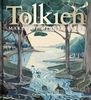
Tolkien Calendar 2019

The official Tolkien calendar, this year containing 12 of the finest watercolours by Alan Lee selected from the three Great Tales of Middle-earth by J.R.R. Tolkien - THE FALL OF GONDOLIN, BEREN AND LUTHIEN and THE CHILDREN OF HURIN - and accompanied by numerous pencil sketches, many unique to this calendar. The Tolkien calendar has become an established publishing event, eagerly looked forward to by Tolkien fans the world over. This year`s content is particularly special, as it includes art inspired by a Tolkien work that is seeing print in its complete form for the very first time, together with the finest paintings from BEREN AND LUTHIEN and THE CHILDREN OF HURIN. Together, these works illustrate Tolkien`s three Great Tales of Middle-earth. To accompany each watercolour painting,
every month features complementary pencil drawings selected by Alan and there are also brand new sketches produced exclusively for this calendar. Alan Lee has depicted famous scenes including Gollum and Bilbo, Rivendell and Smaug the Dragon in his celebrated illustrated editions of `The Hobbit` and `The Lord of the Rings`, but with these brand new paintings and drawings he will take the reader deeper into the enchanting world of Middle-earth than ever before.
RIP - This product is no longer available on our network. It was last seen on 25.09.2019

This page now acts as a permanent archive for this product. Add more information using the comments box below to ensure it can still be found by future generations.

Use our search facility to see if it is available from an alternative contributor.
  • Availability: Out Of Stock
  • Supplier: Stanfords
  • SKU: 9780008296797
Availability: In Stock
£9.99

Product Description

The official Tolkien calendar, this year containing 12 of the finest watercolours by Alan Lee selected from the three Great Tales of Middle-earth by J.R.R. Tolkien
- THE FALL OF GONDOLIN, BEREN & LUTHIEN & THE CHILDREN OF HURIN
- & accompanied by numerous pencil sketches, many unique to this calendar. The Tolkien calendar has become an established publishing event, eagerly looked forward to by Tolkien fans the world over. This year`s content is particularly special, as it

Includes::
art inspired by a Tolkien work that is seeing print in its complete form for the very first time, together with the finest paintings from BEREN & LUTHIEN & THE CHILDREN OF HURIN. Together, these works illustrate Tolkien`s three Great Tales of Middle-earth. To accompany each watercolour painting, every month features complementary pencil drawings selected by Alan & there are also brand new sketches produced exclusively for this calendar. Alan Lee has depicted famous scenes including Gollum & Bilbo, Rivendell & Smaug the Dragon in his celebrated illustrated editions of ` The Hobbit` & ` The Lord of the Rings`, but with these brand new paintings & drawings he will take the reader deeper into the enchanting world of Middle-earth than ever before.

Reviews/Comments

Add New

Intelligent Comparison

Oooops!
We couldn't find anything!
Perhaps this product's unique.... Or perhaps we are still looking for comparisons!
Click to bump this page and we'll hurry up.

Price History

Vouchers

No voucher codes found.
Do you know a voucher code for this product or supplier? Add it to Insights for others to use.

Facebook

Jargon Buster

Calendar - A system for organising dates
World - A physical grouping, commonly used to describe earth and everything associated with ti
Earth - A planet third from the sun. Similar size to Venus but rich in water and complex life.
Month - A period of time originally related to the phases of the earths moon.
Year - The time it takes the planet earth to orbit the sun. This takes around 365.25 days.
Year - 365 days (366 days in a leap year), the time taken for planet earth to make one full revolution around the sun.
Children - A young life form within the early stages of physical development,
Print - A mechanical process of putting text onto paper. It can also relate to a pattern on an item.

Supplier Information

Stanfords
Stanfords was established in 1853 and opened their iconic Covent Garden flagship store in 1901. They have become the top retailer of maps, travel books and accessories in the UK and arguably offer the largest selection of maps and travel books worldwide. Famous names such as Captain Robert Falcon Scott, Ranulph Fiennes and Michael Palin have purchased from Stanfords. They now have a shop in Bristol and both stores together with other venues operate a calendar of events including talks, book signings and exhibitions. As a specialist map retailer, the map selection is comprehensive and includes road maps, street maps and walking maps from worldwide destinations, as well as a selection of world atlases and wall maps. Books include travel guides and travel literature. Stanfords also stock globes, from miniatures made of blue marble to magnificent floor-standing globes. The website features a selection of interesting articles on travel topics.
Page Updated: 2023-11-12 20:15:36

Community Generated Product Tags

Oh No! The productWIKI community hasn't generated any tags for this product yet!
Menu