More From Contributor
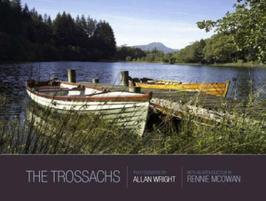
£7.99
Identical twins Sonja & Charlotte are musical prodigies with extraordinary powers. Born on All-Hallows-Eve, the girls could play music before they could walk. They were found one night by Tatty, the Tattooed Lady of the circus, in a pail on her doorstep with only a note & a heart-shaped locket. They`ve been with Tatty ever since, roaming the Outskirts in the circus caravans, moving from place to place. But lately, curious things have started to happen when they play their instruments. During one of their performances, the girls accidentally levitate their entire audience, drawing too much unwanted attention. Soon, ominous Enforcers come after them, & Charlotte & Sonja must embark on a perilous journey through enchanted lands in hopes of unlocking the secrets of their mysterious past. ...
Archived Product
£10.99
This is shortlisted for the 2013 Costa Biography Award. Why were so many authors of the greatest works of literature consumed by alcoholism? In The Trip to Echo Spring, Olivia Laing takes a journey across America, examining the links between creativity & drink in the work & lives of six extraordinary men: F. Scott Fitzgerald, Ernest Hemingway, Tennessee Williams, John Berryman, John Cheever & Raymond Carver. Beautiful, captivating & original, The Trip to Echo Spring strips away the myth of the alcoholic writer to reveal the terrible price creativity can exert. ...
Archived Product
£10.99
We live in a world of seeds. From our morning toast to the cotton in our clothes, they are quite literally the stuff & staff of life: supporting diets, economies, & civilizations around the globe. Just as the search for nutmeg & pepper drove the Age of Discovery, coffee beans fueled the Enlightenment & cottonseed sparked the Industrial Revolution. Seeds are fundamental objects of beauty, evolutionary wonders, & simple fascinations. Yet, despite their importance, seeds are often seen as commonplace, their extraordinary natural & human histories overlooked. Thanks to this stunning new book, they can be overlooked no more. This is a book of knowledge, adventure, & wonder, spun by an award-winning writer with both the charm of a fireside story-teller & the hard-won expertise of a field biologist. A fascinating scientific adventure, it is essential reading for anyone who loves to see a plant grow. ...
Archived Product
£10.95
Gary Fuller`s entertaining & engaging guide enhances geographic know-how with good, old-fashioned fun, using trivia to open up new worlds of knowledge for all readers. Often dismissed as unimportant, trivia here highlights issues that are far from trivial, pondering, for example, what peaceful country requires citizens to keep guns in their homes? what continent contains at least 75 percent of the world`s fresh water? & why aren`t New York, Los Angeles, Chicago, & Philadelphia the capitals of their respective states? An inveterate traveler & geographer extraordinaire, Fuller provides extensive background, clear illustrations, & thorough explanations for each intriguing question, carefully grounding the text in practical geographic concepts. Both enjoyable & enlightening, this book challenges today`s global generation to truly get to know their world. ...
Archived Product
£6.99
The Troll longs for a juicy goat to eat -- but he`s stuck with boring old fish for supper. Bother! Meanwhile, Hank Chief & his pirate crew love fish, but without a decent recipe their slimy, soggy dinner is even worse. If only they could find their buried treasure & pay for a ship`s cook.. .but it seems they`ve sailed to the wrong isl&. Again. Watch the fun unfold as two very different worlds collide in a gloriously comic story from the creators of the highly acclaimed TYRANNOSAURUS DRIP. ...
Archived Product
£14.99
The Trossachs area of the Scottish Highlands on a detailed topographic & GPS compatible map OL46, waterproof version, from the Ordnance Survey’s 1:25, 000 Explorer series. Coverage

Includes::
a section of the Loch Lomond & The Trossachs National Park with parts of the Queen Elizabeth Forest Park, five Munro peaks including Stob Binnein & Ben Vorlich, Callander, Aberfoyle, Balquhidder, Strathyre, Lochearnhead, etc. MOBILE DOWNLOADS: this title & all the other OS Explorer maps include a code for downloading after purchase the digital version onto your smartphone or tablet for viewing on the OS smartphone app.OS EXPLORER SERIES: to see the list of all the titles in the OS Explorer series, both paper & waterproof versions, please click on the series link. The Explorer series, Ordnance Survey’s most detailed maps recommended for anyone enjoying outdoor activities, provides topographic coverage of Great Britain at 1:25, 000 on GPS compatible maps with hiking trails, cycling routes & extensive tourist information. Each printed map is available either on paper or as a waterproof & tear-resistant OS Active Map, as indicated in its title. Britain’s National Parks & other areas of particular tourist interest are presented on often double-sided OL (Outdoor Leisure) maps, whilst most standard format Explorers cover an area of 30 x 20km (approx. 19 x 12 miles). All three versions (paper, waterproof & digital) are the same & provide plenty of recreational & tourist information, indicating the traditional public right of way paths (except in Scotland where different laws apply), including bridleways & byways. National Trails & other long-distance paths are marked, as well as permissive footpaths or bridleways & on-road or traffic-free cycle routes with, where appropriate, their National/ Regional Cycle Network numbers. Boundaries of access land are clearly marked. A wide range of symbols provides additional tourist information, highlighting camping & caravanning sites, information offices & visitors’ centres, parking & picnicking places, country pubs, sport & recreational facilities including cycle hire locations & mountain biking trails, historic buildings & museums, etc. Exceptionally clear presentation of the landscape is provided by contours at 5m or in the uplands at 10m intervals, with additional spot heights plus colouring and/or graphics for different types of woodlands, orchards, heath, marshl&, scree or boulders, & other topographic features. For GPS users the maps have British National Grid lines at 1km intervals, with latitude & longitude given by margin ticks at 1`. Clearly laid out map legend

Includes::
French & German translations for the tourist information symbols.


...
Archived Product
£8.99
The Trossachs area of the Scottish Highlands on a detailed topographic & GPS compatible map OL46, paper version, from the Ordnance Survey’s 1:25, 000 Explorer series. Coverage

Includes::
a section of the Loch Lomond & The Trossachs National Park with parts of the Queen Elizabeth Forest Park, five Munro peaks including Stob Binnein & Ben Vorlich, Callander, Aberfoyle, Balquhidder, Strathyre, Lochearnhead, etc.MOBILE DOWNLOADS: this title & all the other OS Explorer maps include a code for downloading after purchase the digital version onto your smartphone or tablet for viewing on the OS smartphone app.OS EXPLORER SERIES: to see the list of all the titles in the OS Explorer series, both paper & waterproof versions, please click on the series link. The Explorer series, Ordnance Survey’s most detailed maps recommended for anyone enjoying outdoor activities, provides topographic coverage of Great Britain at 1:25, 000 on GPS compatible maps with hiking trails, cycling routes & extensive tourist information. Each printed map is available either on paper or as a waterproof & tear-resistant OS Active Map, as indicated in its title. Britain’s National Parks & other areas of particular tourist interest are presented on often double-sided OL (Outdoor Leisure) maps, whilst most standard format Explorers cover an area of 30 x 20km (approx. 19 x 12 miles). All three versions (paper, waterproof & digital) are the same & provide plenty of recreational & tourist information, indicating the traditional public right of way paths (except in Scotland where different laws apply), including bridleways & byways. National Trails & other long-distance paths are marked, as well as permissive footpaths or bridleways & on-road or traffic-free cycle routes with, where appropriate, their National/ Regional Cycle Network numbers. Boundaries of access land are clearly marked. A wide range of symbols provides additional tourist information, highlighting camping & caravanning sites, information offices & visitors’ centres, parking & picnicking places, country pubs, sport & recreational facilities including cycle hire locations & mountain biking trails, historic buildings & museums, etc. Exceptionally clear presentation of the landscape is provided by contours at 5m or in the uplands at 10m intervals, with additional spot heights plus colouring and/or graphics for different types of woodlands, orchards, heath, marshl&, scree or boulders, & other topographic features. For GPS users the maps have British National Grid lines at 1km intervals, with latitude & longitude given by margin ticks at 1`. Clearly laid out map legend

Includes::
French & German translations for the tourist information symbols.


...
Archived Product
£11.19
Laminated waterproof edition of a detailed topographic map of The Trossachs from the Ordnance Survey Explorer series, covering Callander, Aberfoyle & Lochearnhead. Balquhidder & Strathyre Edition A2; Publication date January 2011 About this series: These highly detailed maps show all the administrative boundaries, settlements as small as isolated farms, the road network down to unfenced roads & country tracks, & field boundaries (hedges & drystone walls) which make navigation across the countryside much easier. Steep gradients on roads are indicated. Various landmarks, e.g. powerlines, archaeological sites, windmills, churches & lighthouses are shown & additional graphics indicate natural terrain features such as cliffs, scree, mud & vegetation variations. The contour interval is 5 metres in the lower parts of the country & 10 metres in the uplands, & spot heights are marked. Each map covers an area of 30 x 20km (i.e. approx. 19 x 12 miles), with some double-sided maps covering more, as indicated in the individual descriptions. The maps are fully GPS compatible, with the National Grid shown at 1km intervals & latitude & longitude indicated by margin ticks at 1'. The Explorer series has replaced the earlier, green-cover Pathfinder maps. The Explorer series is now complete & covers all of Engl&, Wales & Scotl&. Some sheets for popular areas like the National Parks are still branded as Outdoor Leisure (OL) maps, but are now included in this series as the cartography is the same as that in the Explorer Maps. The Explorer maps offer a substantial improvement on the Pathfinder series, with greater use of colour, larger area per map, & stronger emphasis on information for ramblers & tourists. This series is ideal for walking & other outdoor pursuits & each map shows a large amount of information for ramblers & tourists. Public rights of way are shown (except in Scotland), together with other routes with public access: National Trails & Recreational Paths, permitted paths & bridleways, & selected cycle routes. Open access land created under the Countryside & Rights of Way Act 2000 is marked. Tourist information

Includes::
caravan & camp sites, Park & Ride locations, recreation/leisure/sport centres, museums, historic buildings, English Heritage & National Trust sites, rural pubs, etc. The map legend is in English only, except for the tourist information content which is also in French & German.

...
Archived Product
£6.39
A detailed topographic map of The Trossachs from the Ordnance Survey Explorer series, covering Callander, Aberfoyle & Lochearnhead. Balquhidder & Strathyre Edition A2; Publication date September 2010 About this series: These highly detailed maps show all the administrative boundaries, settlements as small as isolated farms, the road network down to unfenced roads & country tracks, & field boundaries (hedges & drystone walls) which make navigation across the countryside much easier. Steep gradients on roads are indicated. Various landmarks, e.g. powerlines, archaeological sites, windmills, churches & lighthouses are shown & additional graphics indicate natural terrain features such as cliffs, scree, mud & vegetation variations. The contour interval is 5 metres in the lower parts of the country & 10 metres in the uplands, & spot heights are marked. Each map covers an area of 30 x 20km (i.e. approx. 19 x 12 miles), with some double-sided maps covering more, as indicated in the individual descriptions. The maps are fully GPS compatible, with the National Grid shown at 1km intervals & latitude & longitude indicated by margin ticks at 1'. The Explorer series has replaced the earlier, green-cover Pathfinder maps. The Explorer series is now complete & covers all of Engl&, Wales & Scotl&. Some sheets for popular areas like the National Parks are still branded as Outdoor Leisure (OL) maps, but are now included in this series as the cartography is the same as that in the Explorer Maps. The Explorer maps offer a substantial improvement on the Pathfinder series, with greater use of colour, larger area per map, & stronger emphasis on information for ramblers & tourists. This series is ideal for walking & other outdoor pursuits & each map shows a large amount of information for ramblers & tourists. Public rights of way are shown (except in Scotland), together with other routes with public access: National Trails & Recreational Paths, permitted paths & bridleways, & selected cycle routes. Open access land created under the Countryside & Rights of Way Act 2000 is marked. Tourist information

Includes::
caravan & camp sites, Park & Ride locations, recreation/leisure/sport centres, museums, historic buildings, English Heritage & National Trust sites, rural pubs, etc. The map legend is in English only, except for the tourist information content which is also in French & German.

...
Archived Product
£12.99
Martha was the youngest of sixteen, handpicked reporters who filed accurate, confidential reports on the human stories behind the statistics of the Depression directly to Roosevelt`s White House. From these pages, we understand the real cost of sudden destitution on a vast scale. We taste the dust in the mouth, smell the disease & feel the hopelessness & the despair. & here, too, we can hear the earliest cadences of a writer who went on to become, arguably, the greatest female war reporter of the 20th century. ...
Archived Product

The Trossachs

Made famous by Sir Walter Scott the Trossachs retains its hold on the Scottish imagination as one of the most romantic areas of the country. With its great hero Rob Roy and its wooded landscape of glens and lochs it is a constantly changing and constantly renewing land and one of the most visited parts of the country. Full of romantic ruins and glorious scenery, this is the first full colour book to focus solely and in depth on this beautiful country.
RIP - This product is no longer available on our network. It was last seen on 25.09.2019

This page now acts as a permanent archive for this product. Add more information using the comments box below to ensure it can still be found by future generations.

Use our search facility to see if it is available from an alternative contributor.
  • Availability: Out Of Stock
  • Supplier: Stanfords
  • SKU: 9781841583549
Availability: In Stock
£9.99

Product Description

Made famous by Sir Walter Scott the Trossachs retains its hold on the Scottish imagination as one of the most romantic areas of the country. With its great hero Rob Roy & its wooded landscape of glens & lochs it is a constantly changing & constantly renewing land & one of the most visited parts of the country. Full of romantic ruins & glorious scenery, this is the first full colour book to focus solely & in depth on this beautiful country.

Reviews/Comments

Add New

Intelligent Comparison

Oooops!
We couldn't find anything!
Perhaps this product's unique.... Or perhaps we are still looking for comparisons!
Click to bump this page and we'll hurry up.

Price History

Vouchers

No voucher codes found.
Do you know a voucher code for this product or supplier? Add it to Insights for others to use.

Facebook

Jargon Buster

Colour - The categorised spectrum of light visable to humans

Supplier Information

Stanfords
Stanfords was established in 1853 and opened their iconic Covent Garden flagship store in 1901. They have become the top retailer of maps, travel books and accessories in the UK and arguably offer the largest selection of maps and travel books worldwide. Famous names such as Captain Robert Falcon Scott, Ranulph Fiennes and Michael Palin have purchased from Stanfords. They now have a shop in Bristol and both stores together with other venues operate a calendar of events including talks, book signings and exhibitions. As a specialist map retailer, the map selection is comprehensive and includes road maps, street maps and walking maps from worldwide destinations, as well as a selection of world atlases and wall maps. Books include travel guides and travel literature. Stanfords also stock globes, from miniatures made of blue marble to magnificent floor-standing globes. The website features a selection of interesting articles on travel topics.
Page Updated: 2023-11-12 20:15:36

Community Generated Product Tags

Oh No! The productWIKI community hasn't generated any tags for this product yet!
Menu