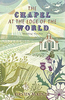
More From Contributor

£29.50
This 2nd edition of the RCC's Pilotage Foundation pilot of the Channel Islands has been completely reworked. New annotated photographs & brand new charts support the rewritten text that describes in detail transits through & between the islands & accessing harbours. In this new edition full use is made from waypoints made to support descriptions of transit. Now in full colour, ' The Channel Islands' is designed to be used in conjunction with Imray Channel Islands chart pack 2500. Peter Carnegie has sailed all the marks described in this pilot with Caprice, a 42' sloop with 65hp auxiliary & 1.6m draught. Companion Book Purchase: RCC PF North Brittany Cherbourg to Ouessant & the Channel Islands. Companion Chart Purchase: Imray Channel Islands chart pack 2500. ...
Archived Product
£14.99
The English Channel is the busiest waterway in the world. Ferries steam back & forth, trains thunder through the tunnel. The narrow sea has been crucial to our development & prosperity. It helps define our notion of Englishness, as an island people, a nation of seafarers. It is also our nearest, dearest playground where people have sought sun, sin & bracing breezes. Tom Fort takes us on a fascinating, discursive journey from east to west, to find out what this stretch of water means to us & what is so special about the English seaside, that edge between land & seawater. He dips his toe into Sandgate`s waters, takes the air in Hastings & Bexhill, chews whelks in Brighton, builds a sandcastle in Sandbanks, sunbathes in sunny Sidmouth, catches prawns off the slipway at Salcombe & hunts a shark off Looe. Stories of smugglers & shipwreck robbers, of beachcombers & samphire gatherers, gold diggers & fossil hunters abound. ...
Archived Product
£7.99
Emilio & Rosa are childhood sweethearts, engaged to be married. But it is 1942 & the war has taken Emilio far from Italy, to a tiny Orkney island where he is a POW. Rosa must wait for him to return & help her mother run the family hotel on the shores of Lake Como, in Italy. Feeling increasingly frustrated with his situation, Emilio is inspired by the idea of building a chapel on the barren isl&. The prisoners band together to create an extraordinary building out of little more than salvaged odds & ends & homemade paints. Whilst Emilio`s chapel will remain long after the POW camp has been left to the sheep, will his love for Rosa survive the hardships of war & separation? For Rosa is no longer the girl that he left behind. She is being drawn further into the Italian resistance movement & closer to danger, as friendships & allegiances are ever complicated by the war. Human perseverance & resilience are at the heart of this strong debut & the small Italian chapel remains, as it does in reality on the island of Lamb`s Holm, as a symbol of these qualities. ...
Archived Product
£26.00
The Charente in a series of guides from Editions Grafocarte/ Editions de l` Ecluse to France’s canals & navigable waterways with mapping showing facilities & navigational hazards along each route, general information on signals & regulations, & descriptions of places of interest. The guide covers the river itself as far as Angoulême, plus provides a maritime chart for the coastal waters between its estuary & La Rochelle. Also included is a street plan of central La Rochelle. Each guide provides mapping of the route showing locks, stop gates, mooring quays, tunnels, weirs, dangerous shoals, sand or mud banks, etc., as well as a wide range of facilities from drinking water & rubbish disposal to various types of shops, restaurants, pharmacies, shipyards & engine repair workshops, etc. The mapping is usually presented as vertical 28 x 8.5cm panels which, together with the annotations, occupy one whole page of the guide & so each cover 14km or more of the route. Also included as necessary are more detailed enlargements of main basins or photographs of bridges, shown usually as viewed from both directions. The text providing navigational information & tips as well as descriptions of places of interest & a general background are kept separate from the maps but, where possible, placed on the adjoining page to the relevant section of the route. The guides also provide general information on rules & regulations, plus illustrations of navigational signals. Each guide also has an index of locations along the route annotated with symbols indicating various facilities, accompanied where possible with contact details.* All of the text, explanations & the map legend are in French, English & German.** Please note:** The publishers’ name has changed from Editions Grafocarte to Editions de l’ Ecluse & the series name shown on each title is Fluviacarte of Navicarte depending on whether mapping of coastal waters is included. Various combinations of these names can be found"ed in other publications on French waterways. ...
Archived Product
£50.00
The Charleston Classic is an illuminated 25 cm diameter globe, with a half meridian & a round base. It features classic style National Geographic cartography showing up-to-date political & physical information. The exquisite look of the mapping is matched with a wealth of details. Current political information, including the latest South Sudan boundaries, shows states in different colours & names capitals apart from the smaller countries. The topography is well presented with relief shading indicating named main mountain ranges, heights for main peaks given in feet, & major rivers are shown. Shading shows seas & oceans depth, & cold & warm currents are indicated & named. The half meridian & base are in a smoky coloured plastic & complementing the modern look. When lit, the globe projects a warm & relaxing light. The Charleston Classic offers good value for your money as it combines excellent mapping with the modern style look that both adults & youngster will enjoy. ...
Archived Product
£10.99
Headstrong & naive, the young Italian aristocrat Fabrizio del Dongo is determined to defy the wrath of his right-wing father & go to war to fight for Napoleon. He stumbles on the Battle of Waterloo, ill-prepared, yet filled with enthusiasm for war & glory. Finally heeding advice, Fabrizio sneaks back to Milan, only to become embroiled in a series of amorous exploits, fuelled by his impetuous nature & the political chicanery of his aunt Gina & her wily lover. Judged by Balzac to be the most important French novel of its time, ” The Charterhouse of Parma” is a compelling novel of extravagance & daring, blending the intrigues of the Italian court with the romance & excitement of youth. ...
Archived Product
£8.99
It is 1948 & a young American couple arrive in France for a holiday, full of anticipation & enthusiasm. But the countryside & people are war-battered, & their reception at the Chateau Beaumesnil is not all the open-hearted Americans could wish for. ...
Archived Product
£7.99
It is 1948 & a young American couple arrive in France for a holiday, full of anticipation & enthusiasm. But the countryside & people are war-battered, & their reception at the Chateau Beaumesnil is not all the open-hearted Americans could wish for. ...
Archived Product
£7.99
Its France, 1761. Beyond the glittering court of Louis XV & Madame de Pompadour at Versailles, lies Paris, a capital in the grip of crime & immorality.. .A police officer disappears & Nicolas Le Floch, a young recruit to the force, is instructed to find him. When unidentified human remains suddenly come to light, he seems to have a murder investigation on his hands. As the city descends into Carnival debauchery, Le Floch will need all his skill, courage & integrity to unravel a mystery which threatens to implicate the highest in the l&. This is the first in a series of six historical crime novels which has sold in excess of 400, 000 copies in French. The author brings eighteenth century Paris vividly to life & the story features real-life characters Madame de Pompadour & Loius XV as well as engaging hero Nicolas le Floch. It is soon to be adapted for French Television. ...
Archived Product
£9.95
Brighton in the Cheeky Guide Series exploring the best places to see & things to do in the city. The guide is divided into 24 distinct sections covering a range of activities, outings, local places of interest, nightlife & recommended places to eat & drink in the city. There are specific sections on The Sea, Shopping, Cafes, Specialist & Veggie Food, Restaurants, Watering Holes, Local Entertainment, the Music Scene, Hay Scene, Mind, Body & Spirit & Kids ...
Archived Product

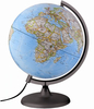
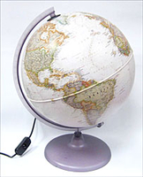
The Charleston Illuminated Globe (Exec NGS)

The Charleston is an illuminated 30 cm diameter globe, with a half meridian and a round base. It features antique style National Geographic cartography showing up-to-date political and physical information. The exquisite look of the mapping is matched with a wealth of details. Current political information, including the latest South Sudan boundaries, shows states in different colours and names capitals apart from the smaller countries. The topography is well presented with relief shading indicating named main mountain ranges, heights for main peaks given in feet, and major rivers are shown. The presentation of the ocean floor is impressive as shades show the continental shelf around the land masses and numerous ridges, many with names. The half meridian and base are in a smoky
coloured plastic and complement the overall stylish appearance. When lit the globe projects a warm and relaxing light.The Charleston offers good value for money as it combines excellent mapping with the antique style look that both adults and youngster will enjoy.
RIP - This product is no longer available on our network. It was last seen on 25.09.2019

This page now acts as a permanent archive for this product. Add more information using the comments box below to ensure it can still be found by future generations.

Use our search facility to see if it is available from an alternative contributor.
  • Availability: Out Of Stock
  • Supplier: Stanfords
  • SKU: 9786000502324
Availability: In Stock
£70.00

Product Description

The Charleston is an illuminated 30 cm diameter globe, with a half meridian & a round base. It features antique style National Geographic cartography showing up-to-date political & physical information. The exquisite look of the mapping is matched with a wealth of details. Current political information, including the latest South Sudan boundaries, shows states in different colours & names capitals apart from the smaller countries. The topography is well presented with relief shading indicating named main mountain ranges, heights for main peaks given in feet, & major rivers are shown. The presentation of the ocean floor is impressive as shades show the continental shelf around the land masses & numerous ridges, many with names. The half meridian & base are in a smoky coloured plastic & complement the overall stylish appearance. When lit the globe projects a warm & relaxing light. The Charleston offers good value for your money as it combines excellent mapping with the antique style look that both adults & youngster will enjoy.

Reviews/Comments

Add New

Intelligent Comparison

Oooops!
We couldn't find anything!
Perhaps this product's unique.... Or perhaps we are still looking for comparisons!
Click to bump this page and we'll hurry up.

Price History

Vouchers

No voucher codes found.
Do you know a voucher code for this product or supplier? Add it to Insights for others to use.

Facebook

Jargon Buster

Diameter - A measurement across a circle passing through the middle
Plastic - A generic term for a synthetic product used in the manufacture of products
Cm - Centimetres, one centimetre is equal to 10 milimetres
Date - A day on a calendar
Date - A social activity whith a current or potential partner
antique - An old collectible item with desirable qualities.
Physical - Used to describe strength or visual properties of an item
Stylish - A desirable design or layout
Smoky - A tone of grey, can also relate to a haze.

Supplier Information

Stanfords
Stanfords was established in 1853 and opened their iconic Covent Garden flagship store in 1901. They have become the top retailer of maps, travel books and accessories in the UK and arguably offer the largest selection of maps and travel books worldwide. Famous names such as Captain Robert Falcon Scott, Ranulph Fiennes and Michael Palin have purchased from Stanfords. They now have a shop in Bristol and both stores together with other venues operate a calendar of events including talks, book signings and exhibitions. As a specialist map retailer, the map selection is comprehensive and includes road maps, street maps and walking maps from worldwide destinations, as well as a selection of world atlases and wall maps. Books include travel guides and travel literature. Stanfords also stock globes, from miniatures made of blue marble to magnificent floor-standing globes. The website features a selection of interesting articles on travel topics.
Page Updated: 2023-11-12 20:15:36

Community Generated Product Tags

Oh No! The productWIKI community hasn't generated any tags for this product yet!
Menu