More From Contributor

£5.99
” Moon Spotlight Sedona” is a 60-page compact guide covering the best of this red rock city. Sedona resident Kathleen Bryant offers her firsthand advice on must-see attractions, as well as maps with sightseeing highlights, so you can make the most of your time. This lightweight guide is packed with recommendations on entertainment, shopping, recreation, hotels, food, & transportation, making navigating the beautiful area of Sedona uncomplicated & enjoyable. This Spotlight guidebook is excerpted from ” Moon Phoenix, Scottsdale & Sedona.” ...
Archived Product
£17.99
Serra Tramuntana, the mountains of north-west Mallorca, on a set of two double-sided, contoured, GPS compatible hiking maps at 1:35, 000 from Map Solutions printed on light, waterproof & tear-resistant synthetic paper. Excellently presented topographic base has contours at 20m intervals with plenty of spot heights & names of peaks & other topographic features, plus coloring for woodlands. An overprint highlights waymarked hiking paths, indicating more difficult climbing sections & routes which are part of the GR221 & GR222 long-distance trails. Road network indicates bus connections & for drivers shows car parks & locations of petrol supplies. Railway lines are shown with stations. Symbols show various types of accommodation including mountain huts & refuges & agrotourism farms, selected restaurants, places of interest, etc. The maps have UTM margin ticks. Map legend

Includes::
English. Also provided is a glossary of Catalan terms useful for hikers.

...
Archived Product
£6.99
” Moon Spotlight Sonoma Valley” is a 145-page compact guide covering California`s Southern & Northern Sonoma region. Author Elizabeth Linhart Veneman offers her seasoned advice on must-see attractions, &

Includes::
maps with sightseeing highlights so you can make the most of your time. This lightweight guide is packed with recommendations on sights, entertainment, shopping, recreations, accommodations, food, & transportation, as well as easy-to-read maps, making navigating this idyllic region uncomplicated & enjoyable. This Spotlight guidebook is excerpted from ” Moon Napa & Sonoma.”

...
Archived Product
£15.99
The Moleskine Squared Large Notebook has 192 squared pages of acid-free paper, thread bound into the hardwearing, black synthetic ` Moleskine` cover. There is an elastic enclosure & expandable inner pocket. The Classic Moleskine series is where you will find the more traditional versions of these timeless notebooks, available in various sizes & colours where shown. Be it for jotting down the odd thought, taking an address, or simply doodling, these classic little chaps ensure that you’ll always do it in style. For over two centuries Moleskine was the notebook of choice for artists, intellectuals & travellers. Numbered among its fans were Van Gogh, Ernest Hemingway & Bruce Chatwin. Imagine how many sketches, notes, ruminations & secrets these discrete little black books have carried between their pages over the years. The original pocket notebook. ...
Archived Product
£14.99
Moleskine Reporter Notebook
- Black, Hard Cover, Squared Paper, Large is a vertical flip pad made from 192 pages of squared,
...
Archived Product
£12.99
Montagnola Senese & Bosco di Lecceto in a series of hiking maps from Edizioni Multigraphic covering Tuscany, parts of Umbria, & the adjoining areas. The cartography is rather old fashioned & sometimes not as clear as in the other map series but for many areas, especially for parts of Tuscany, these are the only hiking maps available. Most maps have contours at 25-metre intervals, with some relief shading & colouring for forests. An overprint highlights hiking paths, including all the popular hiking routes such as the Grandi Sentieri della Provincia di Siena, etc. The overprint also shows campsites &, where appropriate, mountain refuges & other types of alpine accommodation. Some of the maps indicate latitude & longitude at the map corners, but with longitude sometimes based on Rome rather than Greenwich. Map legends vary, most maps include English. Some maps include street plans & additional notes on the region. For more details see individual descriptions.* In this title:* contours at 25 metres intervals, with spot heights & colouring for forested areas. The overprint highlights footpaths, showing their Club Alpino Italiano numbers, as well as routes waymarked by local authorities, all with brief descriptions (in Italian only) on the reverse of the map. Also highlighted are interesting villages, campsites, numerous caves (listed on the reverse), etc. The map has a 1km grid (no coordinates provided) & margin ticks for latitude & longitude (based on Rome & Greenwich). Map legend

Includes::
English. All additional notes on the reverse are in Italian only

...
Archived Product
£13.99
Area native & current Virginia resident Michaela Gaaserud provides travelers with an insider`s perspective on two of the nation`s most historically significant states. An experienced guidebook author, Gaaserud offers up original trip ideas to help visitors make the most of their time, such as Five Days for the Active Traveler & the Seven-Day Historical Road Trip & Pub Tour. With comprehensive coverage for all interests--from strolling Embassy Row & visiting the monuments in Washington DC to hiking in Shenandoah National Park, from getting some sun on Colonial Beach to seeing the Beauregard Civil War Cemetery--” Moon Virginia & Maryland” gives travelers the tools they need to create a more personal & memorable experience. ...
Archived Product
£19.99
Very attractive Executive Political Wall Map of the World from Maps International, size 136 x 84cm (53.5” x 33” approx), with countries shown in colours from the brown
- pink
- beige palette, set off by oceans in the shades of silvery grey, plus very effective background shading to highlight mountain ranges. Names of countries, cities & topographic features are given in their English versions. Within USA, Canada, Brazil & Australia the map also shows administrative boundaries with names of state or provinces. Very effective relief shading shows physical geography, with plenty of names of various topographic features such as mountain ranges, peaks, deserts, etc. Colouring of the oceans also shows different depths &

Includes::
markings for the depth of the ocean floor. Latitude & longitude lines are drawn at 15°intervals. Projection is Van der Grinten. Current edition of this map was published in late 2013 & shows both South Sudan & the revised International Date Line.


...
Archived Product
£30.00
Glow in the Dark World Wall Map, an innovative & imaginative presentation with the outlines of the continents & the islands, symbols for cities & the road network glowing in the dark, producing a very powerful image of the world as well as highlighting its more densely populated regions. When viewed in full light, the map shows countries in different shades of green against the grayish colouring of the oceans. International borders are marked (but not highlighted to glow in the dark) & in larger countries state or provincial borders are also shown. Country & city names are in their English versions. Relief shading shows main mountain ranges & both on land & the seas spot heights/depths are marked. Symbols for cities indicate the size of their population & when glowing in the dark provide an interesting picture of the population distribution across the world. The map has latitude & longitude lines at 15° intervals. Projection is Van der Grinten. ...
Archived Product
£11.99
Small, 69.5 x 53.5cm (27” x 21” approx.), political map of the world from Maps International, with countries shown in bright vivid colours against light blue oceans. Country names are in large, clearly legible print. English versions of all city names are used throughout. Within USA, Canada & Brazil internal state or provincial boundaries are indicated. Central Pacific, from Alaska/ Siberia to New Zeal&, is repeated on both sides of the map for better presentation of that region. The map has well designed relief shading to show the mountainous areas like the Rockies or the Andes, enhancing the overall presentation. The colouring of the oceans also shows different depths. Projection is Van der Grinten. Clocks show time difference from GMT (but without the map indicating the exact geographical area covered by each time zone). A decorative panel under the map displays flags of various countries.* This 1:60, 000, 000 map is also available encapsulated, laminated & with hanging strips, or framed & mounted either on pin board or on magnetic board. The same design is also available is three larger sizes
- please click on the link above to see the full list of currently available titles.
...
Archived Product

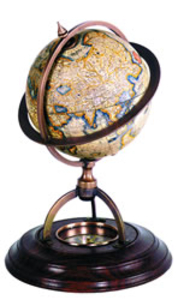
Terrestrial Globe With Compass

Classic globes without a matching compass were considered incomplete. Our wonderfully constructed bronze and wood stand with paper globe includes true reproduction of 17th C. ”dry” compass. Twelve paper gores applied to the globe are printed after originals drawn by Gerardus Mercator, the inventor of the Mercator projection, which was used from the 16th C. until the middle of the 20th C. Scientific, decorative, historical.If we do not have this item in stock we will order it for you from our supplier. Delivery generally takes 3 weeks within the UK. For overseas delivery queries please email sales@stanfords.co.uk
RIP - This product is no longer available on our network. It was last seen on 25.09.2019

This page now acts as a permanent archive for this product. Add more information using the comments box below to ensure it can still be found by future generations.

Use our search facility to see if it is available from an alternative contributor.
  • External links may include paid for promotion
  • Availability: Out Of Stock
  • Supplier: Stanfords
  • SKU: 0781934283201
Availability: In Stock
£85.00

Product Description

Classic globes without a matching compass were considered incomplete. Our wonderfully constructed bronze & wood stand with paper globe

Includes::
true reproduction of 17th C. ”dry” compass. Twelve paper gores applied to the globe are printed after originals drawn by Gerardus Mercator, the inventor of the Mercator projection, which was used from the 16th C. until the middle of the 20th C. Scientific, decorative, historical. If we do not have this item in stock we will order it for you from our supplier. Delivery generally takes 3 weeks within the UK. For overseas delivery queries please email sales@stanfords.co.uk

Reviews/Comments

Add New

Intelligent Comparison

Oooops!
We couldn't find anything!
Perhaps this product's unique.... Or perhaps we are still looking for comparisons!
Click to bump this page and we'll hurry up.

Price History

Vouchers

No voucher codes found.
Do you know a voucher code for this product or supplier? Add it to Insights for others to use.

Facebook

Jargon Buster

Paper - A thin sheet mainly used for writing. Available in a variety of colours. Made mainly from wood pulp.
UK - United Kingdom - An island nation in Europe
Dry - A term used to describe an item with has little or no water present
Dry - A term used in wine making to describe the lack of sugar (sweetness)
email - An electronic communication method. Short for Electronic Mail.
delivery - The method by which something is delivered from one location to another
Wood - A hard material found in trees. Used for tool making, fuel and construction.
Classic - Something that is still like it was originally a high quality standard.
Decorative - Making things look more appealing and attractive.
Reproduction - A process of making a copy of something.

Supplier Information

Stanfords
Stanfords was established in 1853 and opened their iconic Covent Garden flagship store in 1901. They have become the top retailer of maps, travel books and accessories in the UK and arguably offer the largest selection of maps and travel books worldwide. Famous names such as Captain Robert Falcon Scott, Ranulph Fiennes and Michael Palin have purchased from Stanfords. They now have a shop in Bristol and both stores together with other venues operate a calendar of events including talks, book signings and exhibitions. As a specialist map retailer, the map selection is comprehensive and includes road maps, street maps and walking maps from worldwide destinations, as well as a selection of world atlases and wall maps. Books include travel guides and travel literature. Stanfords also stock globes, from miniatures made of blue marble to magnificent floor-standing globes. The website features a selection of interesting articles on travel topics.
Page Updated: 2023-11-12 20:15:36

Community Generated Product Tags

Oh No! The productWIKI community hasn't generated any tags for this product yet!
Menu