
 United Kingdom
 France
 Germany
 Netherlands
 Sweden
 USA
USA
 Italy
Italy
 Spain
Spain
More From Contributor


Tennesse Guide Map
Tennessee in a series of US state maps from the National Geographic with cartography from Mapquest, including city maps of Memphis, Nashville, Chattanooga and Knoxville, enlargements for the Great Smoky Mountains National park including the part in North Carolina and the Land Between the Lakes National Recreation Area with its Kentucky part, plus a scenic drive route along the Natchez Trace Parkway. The map is printed on lightweight, waterproof and tear-resistant plastic paper.Maps in the NGS State Series clearly show each state
Product Description
Reviews/Comments
Add New
Intelligent Comparison
Archived Product
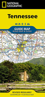
Tennessee NGS Guide Map Stanfords
£6.99
Archived Product
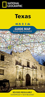
Texas NGS Guide Map Stanfords
£9.99
Vouchers
No voucher codes found.
Do you know a voucher code for this product or supplier? Add it to Insights for others to use.
Do you know a voucher code for this product or supplier? Add it to Insights for others to use.
 Denmark