More From Contributor

£7.99
Jane Shaw was working as a volunteer in Chelsea`s famous Physic Garden when she earned a placement to work for a year on a very special organic garden in Greece. But this was to be no easy-going break in the Mediterranean. The five-acre plot, which Jane swiftly named ` Alcatraz`, was devoid of creature comforts, perched on a steep, remote hillside that was blindingly hot in summer & freezing in winter, & overseen by a 74-year-old, passionate, mercurial eccentric English lady called Joy. On arrival, Jane is immediately drawn into the intrigue of village life, such as the ongoing feud with the nouveau riche ex-pat neighbour with a sports car, whom Joy suspects has dug an illegal bore hole to water his terraced lawns. But most of all she is beguiled by the vibrant energy of the landscape, the folklore, the food & the numerous engaging characters who flock to Joy as the wise matriarch of the locale. The story arcs through a year of seasons in the garden as Jane learns to love its wild beauty & to relish the hard work & care it needs. This is a charming, wildly entertaining & joyful portrait of a very special place, & will appeal to anyone who loves gardening, or who has enjoyed books such as Driving Over Lemons. ...
Archived Product
£9.99
Talkot, sheet no. 2981-06, in the topographic survey of Nepal at 1:50, 000 published by the Nepali Government in the late 1990s & early 2000s & produced from remote sensing data by Finnish cartographers as part of that country’s international aid program. The maps cover 15’ x 15’ quadrangles.IMPORTANT – PLEASE NOTE BEFORE ORDERING: AVAILABILITY: although, theoretically at least, still in print, these maps are very difficult to get locally in Nepal and/or from various suppliers elsewhere specializing in obtaining such maps. DELIVERIES MAY TAKE SEVERAL WEEKS OR EVEN MONTHS.PROBLEMS WITH PLACE NAMES: reports from previous users indicate that transliteration of place names differs from that used widely not only on other maps & in guide books but also on the ground itself, in road signs & in the tourist & trekking industry in general. Whilst most names are similar enough to be easily recognizable, e.g. Namche Bajar for Namche Bazar or Lantan for Langtang, we have been told of confusion & difficulties arising from different spellings appearing on these maps.TREKKING ROUTES & TOURIST INFORMATION: whilst the maps show foot trails & mark locations of temples, etc, they carry no specific trekking information. Major trekking routes & places of interest are not highlighted. There is no marking for base camps & other tourist facilities. Map specifications: Contours are at 40m intervals, with graphics and/or coloring to show various features of the terrain (glaciers with moraines & crevasses, quarries, gravel or clay pits, etc.) & vegetation (forests, bush, grass, orchards & plantations, etc). Additional comments such as “open mixed forest mainly bajh & pine” annotate many area. The maps have numerous spot heights, but relatively few peaks are named. Areas outside the country’s borders are left blank. Settlements in remote areas are indicated by markings for individual buildings & the placing of names does not always make it clear which group of buildings they refer to. Road network distinguishes between major & minor foot trails. Symbols mark features such as temples, schools & hospitals, police stations, etc. Also shown are the country’s administrative divisions. The maps have a 1-km UTM grid, plus latitude & longitude lines at intervals of 5’. Map legend & all the text is in English. Coverage: the whole country is now covered, with the north at 1:50, 000, plus central & southern Nepal at 1:25, 000. The two series are complementary, do not overlap & use the same grid & numbering system (apart from the Lumbini Zone, where a different grid & numbering are used). For areas not shown on our grid & titles not listed here, please contact us by e-mail, but please do bear in mind the problems with availability & the likely very long delivery time. ...
Archived Product
£9.99
This title contains five stories of tragic loss at sea. Once nearly swept from the seas, tall ships have experienced a fifty-year renaissance as sail training & passenger vessels. But that resurgence has had a tragic side, & professional mariner & maritime scholar Dan Parrott explores it in this groundbreaking reconstruction of five infamous losses that claimed 112 lives. Parrott's vivid re-creations of each final voyage dissect the circumstances of loss from forensic evidence, expert testimony, survivors' memories, & his own considerable experience. Rich with history & lore, Tall Ships Down shows unforgettably how small & seemingly insignificant lapses can produce fatal consequences at sea.' An engaging
- & heartrending
- book'
- Ocean Navigator. ' In addition to being a fabulous read, Tall Ships Down is a sailing seminar for both active & armchair sailors'
- Sailing. ' The careful detail makes gripping reading. Not much detective fiction holds a reader's attention so well'
- Wooden Boat. 'A closely reasoned seaman's appraisal'
- SAIL.' This extraordinary book is a must-read for anyone interested in the world of tall ships'
- Tall Ships & Sail Training International. ' An important contribution to maritime studies. Parrott writes with ease & authority, carefully blending both historical & technical data'
- Baltimore Sun. ' If you're a fan of sea stories, you should have a great time reading Tall Ships Down'
- Connecticut Post.


...
Archived Product
£30.00
Tall ships epitomize the glamour, majesty & romance of the sea. This book
- supported & endorsed by Sail Training International
-

...
Archived Product
£7.25
Tallahassee in Florida in a series of indexed street plans of US cities from Universal MAP. The plan presents the city with is outer suburbs, including the Tallahassee Regional Airport, plus Havana shown on an inset. Street plans from Universal MAP are indexed & show each city’s administrative divisions, zip code areas & various facilities & services. ...
Archived Product
£8.50
Indexed street map of the city, reaching as far south as the Tondi district, west to include the lake Harku Jarv & east to Ulemiste district & the airport. Detail

Includes::
railways, car parks, city walls, viewpoints, parks, cemeteries, industrial areas, public buildings, theatres, museums, monuments, hospitals, churches, synagogues, post offices, tourist information offices. Multilingual legend

Includes::
English. Street index on reverse.


...
Archived Product
£7.99
Indexed street plan of Tallinn, with an enlargement for the city centre, public transport lines, locations of petrol stations & parking facilities, places of interest, etc. The plan covers the whole of the city within its administrative boundary, with an enlargement extending it eastwards to include Maardu. Tram, trolleybus & bus routes are shown with stops & line numbers. The plan shows one way streets, locations of petrol stations car parks. Symbols highlight various places of interest, hotels & facilities, etc. Map legend

Includes::
English. An enlargement shows the city centre at a more detailed scale of 1:10, 000.

...
Archived Product
£7.99
Tallinn on a double-sided street plan from Estonia’s leading map publishers Regio, covering the central districts at 1:10, 000 & the whole city at 1:37, 000, with tram & trolleybus lines with stops, numerous tourist sights, etc. On one side is a street plan of Tallinn’s central districts, including its historic Old Town. Tram & trolleybus lines are shown with names of stops & for visitors by car one way streets plus locations of car parks & petrol stations are marked. Streets are annotated with selected house numbers for easier identification of atlases. Symbols mark selected hotels (with names), markets & shopping centres, museums & cultural institutions, foreign embassies, etc. 45 of the city’s principal sights are prominently highlighted & annotated with mobile phone numbers for English language descriptions. On the reverse is a street plan of the whole city at 1:37, 000, with tram & trolleybus lines. Principal traffic arteries are highlighted, as well as locations of petrol stations plus various sights & services outside the city centre. Neither street plan is indexed, Also provided is a map of the city’s parking zones with information how to pay by mobile phone. Map legend & all other information include English. ...
Archived Product
£8.99
Tallinn on a waterproof & tear-resistant indexed street plan from Jana Seta, including on the reverse side an enlargement of the city’s Old Town, a diagram of the public transport lines, plus descriptions of main places of interest. On one side is the city with its outer districts indicating locations of six main places of interest outside the city centre. Principal traffic arteries are highlighted & one way streets, car parks & locations of petrol stations are marked. On the reverse the city’s historic heart & the surrounding area is shown in greater detail, with seven more principal sights highlighted. Also provided is a diagram of the tram & suburban rail networks, including the bus to the airports. Map legend & descriptions of places of interest include English. ...
Archived Product
£4.99
Tallinn in New Holland’s “ Best of…” series; comprising a range of pocket-sized guides exploring a variety of cities worldwide. Designed to be practical, informative & user-friendly, each title in the series presents the highlights of the city concisely, providing a directory of the best places to stay, eat, shop & relax. An overview section provides a brief summary of the l&, history, government & economy, people & the arts. Each guide is designed to make essential information easy to access, with individual sections on the city’s main tourist attractions (‘highlights’), in addition to dedicated sections on sightseeing, activities, shopping, accommodation, eating out, entertainment & excursions. There is also a travel tips chapter with practical advice on getting there & around, when to go, communications, emergencies, health, insurance, safety, embassies, money, tipping, electricity, time, toilets & some basic vocabulary. ...
Archived Product

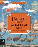
Tallest Tower, Smallest Star: A Pictorial Compendium Of Comparisons

Have you ever wondered how a dinosaur would measure up against the Great Pyramids of Giza, if a hummingbird could outfly a jet plane, or how many atoms could fit inside a grain of sand? These are just some of the questions explored in this extraordinary book of comparisons.Detailed images drawn to scale, informative text and unexpected visual analogies will help the reader to comprehend just how fast, how strong, how small and how big things really are. With stunning Victorian-style artwork by award-winning illustrator Page Tsou, this visual feast of a compendium will surprise and delight inquisitive minds in equal measure.Peek inside and discover a beetle that is stronger than an elephant, meet the pterosaur that was bigger than a spitfire and explore the furthest reaches of the
known universe.
RIP - This product is no longer available on our network. It was last seen on 25.09.2019

This page now acts as a permanent archive for this product. Add more information using the comments box below to ensure it can still be found by future generations.

Use our search facility to see if it is available from an alternative contributor.
  • Availability: Out Of Stock
  • Supplier: Stanfords
  • SKU: 9781783708451
Availability: In Stock
£14.99

Product Description

Have you ever wondered how a dinosaur would measure up against the Great Pyramids of Giza, if a hummingbird could outfly a jet plane, or how many atoms could fit inside a grain of sand? These are just some of the questions explored in this extraordinary book of comparisons. Detailed images drawn to scale, informative text & unexpected visual analogies will help the reader to comprehend just how fast, how strong, how small & how big things really are. With stunning Victorian-style artwork by award-winning illustrator Page Tsou, this visual feast of a compendium will surprise & delight inquisitive minds in equal measure. Peek inside & discover a beetle that is stronger than an elephant, meet the pterosaur that was bigger than a spitfire & explore the furthest reaches of the known universe.

Reviews/Comments

Add New

Intelligent Comparison

Oooops!
We couldn't find anything!
Perhaps this product's unique.... Or perhaps we are still looking for comparisons!
Click to bump this page and we'll hurry up.

Price History

Vouchers

No voucher codes found.
Do you know a voucher code for this product or supplier? Add it to Insights for others to use.

Facebook

Jargon Buster

Elephant - A large land mammal found in Africa and Asia
star - A giant ball of plasma held together by gravity.
strong - A descriptive word for an item that has physical strength
Small - something that takes up less space than normal.
Dinosaur - Animals that are now extinct due to not adapting.
Universe - Every matter and space, thought to be around 10 billion years old.

Supplier Information

Stanfords
Stanfords was established in 1853 and opened their iconic Covent Garden flagship store in 1901. They have become the top retailer of maps, travel books and accessories in the UK and arguably offer the largest selection of maps and travel books worldwide. Famous names such as Captain Robert Falcon Scott, Ranulph Fiennes and Michael Palin have purchased from Stanfords. They now have a shop in Bristol and both stores together with other venues operate a calendar of events including talks, book signings and exhibitions. As a specialist map retailer, the map selection is comprehensive and includes road maps, street maps and walking maps from worldwide destinations, as well as a selection of world atlases and wall maps. Books include travel guides and travel literature. Stanfords also stock globes, from miniatures made of blue marble to magnificent floor-standing globes. The website features a selection of interesting articles on travel topics.
Page Updated: 2023-11-12 20:15:36

Community Generated Product Tags

Oh No! The productWIKI community hasn't generated any tags for this product yet!
Menu