More From Contributor
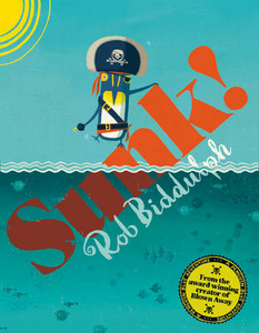
£7.99
The Sunflower Landscapes guide series explores the best walking & touring possibilities in the region or area. Detailed information about touring by hired car or public transport, as well as on foot, is provided, helping walkers to navigate & plan day-trips. Shorter strolls are also included as an alternative for each main route for those seeking more leisurely days out. The guides are structured in two main parts – Touring & Walking – that explore each route with detailed references to public transport & car directions to make each walk more accessible. Suggested car-touring routes of the area are also included. Each car tour describes a route by car with suggestions for stop-off places & things to see on the way, including any picnicking sites. About fifteen suggestions for the best picnic stops are included at the start of the book & these are cross-referenced with the fold-out map & walk descriptions. The ‘ Walking’ section

Includes::
an average of fifteen recommended walks, many of which are circular tours. A detailed introduction provides information on waymarking & maps, what to take, weather & where to stay. Each walk begins with information about distance, difficulty grading, waymarking, how to get there, suggested clothing & equipment, language hints & shorter & alternative routes to the main walk. A concluding section provides useful guidance on local transport. Colour photographs & Ordnance Survey extracts accompany each route.

...
Archived Product
£7.99
The Sunflower Walk & Eat guide series are designed for short breaks & feature about ten, mostly easy walks, with restaurants en route & local recipes; ideal for countryside & good food enthusiasts. The titles in this series cover mainly cities & include some of the most famous sights, as well as a few excursions in the surrounding areas, easily accessible by public transport & all accompanied by large scale localised maps & city plans. All walks include one or two restaurants with their typical menus, price range, contact details & a little information about it. Each walk also feature a local speciality recipe for you to try back home! Advice on planning your visits can be found in the introduction &

Includes::
tips on how & when to get there, what to take, how to plan your walks, bus & rail tickets, parking, tourist information etc. A section on food explores local markets, health food shop & wheat, gluten and/or dairy free eating & cooking. Colour photographs accompany the text throughout.

...
Archived Product
£15.95
The Sunglasses Case by Wild & Wolf featuring an extract of a map Venice, semi hard casing with decorative turquoise ribbon & push button closure. Made of synthetic leather, with padded turquoise inner felt lining, the case offers protection for sunglasses against scratches & impacts, it

Includes::
a fabric loop fixed on the side. The Venice map extracts features the Isola di San Giorgio Maggiore & Piazza San Marco. This is a very useful, colourful & unique accessory, & must-have for keeping your sunglasses safe. Coordinate your travel set or mix & match with other items of the Wild & Wolf Metropolitan range!

...
Archived Product
£8.99
By the same author as the bestselling Total Loss, this is a new collection of terrifying & compelling accounts of yachts lost at sea. The seven deadly causes of loss continue to take their toll, & Paul Gelder has compiled first-hand accounts of shipwreck & sinking caused by Collision, Gear Failure, Stress of Weather, Faulty Navigation, Fire, Crew Failure & Exhaustion. The moving, emotionally charged descriptions of shipwrecked sailors abandoning their yachts at sea will have you on the edge of your seat. But these accounts are more than just gripping tales of disaster
- they carry valuable lessons which the survivors have been able to pass on to all who go to sea for pleasure.
...
Archived Product
£12.99
Penguin Blue is back, in a swashbuckling new adventure about pirates, treasure, & friendship!A pirate hat.A sunny day. For Penguin Blue A game to play. Your favourite Penguin & his friends are back in a new adventure, & this time they`re pirates
- ARRRRR! Sailing the seven seas in search of treasure, Captain Blue & his friends are unexpectedly SUNK! But with a shipwreck to explore & a mysterious stranger on a desert island to meet, they might still find some treasure after all... The fourth book from the award-winning, bestselling picture book star Rob Biddulph.
...
Archived Product
£25.00
Beneath the waters of Abukir Bay, at the edge of the Nile Delta, lie the submerged remains of the ancient Egyptian cities Naukratis & Thonis-Heracleion, which sank over 1, 000 years ago but were dramatically rediscovered in the 20th century & brought to the surface by marine archaeologists in the 1990s. These pioneering underwater excavations continue today, & have yielded a wealth of ancient artefacts, to be exhibited in Britain for the first time in 2016. Through these spectacular finds, this book tells the story of how two iconic ancient civilizations, Egypt & Greece, interacted in the late first millennium bc. From the foundation of Naukratis & Thonis-Heracleion as trading posts to the conquest of Alexander the Great, through the ensuing centuries of Ptolemaic rule to the ultimate dominance of the Roman Empire on the world stage, Greeks & Egyptians lived alongside one another in these lively cities, sharing their politics, religious ideas, languages, scripts & customs. Greek kings adopted the regalia of the pharaoh; ordinary Greek citizens worshipped in Hellenic sanctuaries next to Egyptian temples; & their ancient gods & mythologies became ever more closely intertwined. This book showcases a spectacular collection of artefacts, coupled with a retelling of the history by world-renowned experts in the subject (including the sites` long-term excavator), bringing the reader face-to-face with this vibrant ancient society. Accompanies the most sensational exhibition of ancient Egyptian & Greek discoveries to be held in the UK for decades, opening at the British Museum. ...
Archived Product
£23.99
Map No. 10078, Sunndalsøra, in the new topographic survey of Norway at 1:50, 000 covering the country on 195 double-sided sheets & first published by Nordeca in 2011
- 2012; fully GPS compatible, indicating waymarked footpaths, campsites, tourist huts, illuminated ski runs, etc. The maps, now published by Nordeca, the successors to Statens Kartverk & its subsequent owners the Ugland Group, are printed on light, waterproof & tear-resistant synthetic paper. Each map covers an area of 62x 45 kilometres (39 x 28 miles approx.), with a 2-km overlap between the sheets. The maps have contours at 20m intervals (10m glacier contours), plus colouring & graphics to show cultivated areas, bogs, forests, etc. In addition to all the information expected of topographic mapping at this scale the maps distinguish between waymarked & unmarked footpaths & show campsites, tourist huts (serviced/self service/no supplies), country hotels & restaurants, & illuminated ski trails. The series uses EUREF89 (WGS84) datum & the maps have a 1-km UTM grid. Map legend is in Norwegian & English. Each title comes in a sturdy protective card envelope.
...
Archived Product
£16.99
Topographic survey of Sweden at 1:50, 000, the Terrängkartan, from the Lantmäteriet, covering most of the country in 244 double-sided maps. Please note: the mountainous regions of central & northern Sweden are not covered by this series but presented in a separate “ Fjällkartan
- Mountain Map” series also listed on our website. Each 1:50, 000 topographic survey map covers an area of 37.5 x 40km. The maps have contours at 5 metre intervals, plus relief shading & graphics for rocky outcrops & boulders. Further graphics and/or colouring show different types of land use or vegetation (forests, arable l&, orchards, marshes, peat bogs, etc). An unusual feature of this survey is the colouring indicating buildings below or above two storeys high & “leisure/holiday homes”. The maps indicate privately maintained roads & include all other information expected of topographic survey at this scale. The maps have a 1-km UTM grid, plus latitude & longitude lines 5’ intervals. Map legend

Includes::
English. For coverage of the country’s most visited hiking areas in central & northern Sweden please see Lantmäteriet’s Mountain Map series, listed separately on our website.


...
Archived Product
£23.99
Sunnmørsalpane East area in Norway in a series of GPS compatible recreational maps at 1:50, 000 with cartography from Norway’s topographic survey & additional tourist information. Contours lines are drawn at 20m intervals. The overprint varies from title to title, but

Includes::
local footpaths, in some cases distinguishing between easy & more difficult trails, as well as mountain huts & campsites. Many titles also indicate cycle or ski routes, other accommodation possibilities, sport & recreational facilities, including alpine skiing slopes, places of interest, etc. The maps have a UTM grid & margin ticks giving latitude & longitude. Map legend

Includes::
English. Several titles have on the reverse additional tourist information, although in most cases in Norwegian only.PLEASE NOTE: This title is also available as part of a 2-map set which

Includes::
the Sunnmørsalpane West map. To see the list of Turkart maps at 1:50, 000 & links to Turkart series at 25K, 100K & Hiking Sets please click on the series link above.


...
Archived Product
£23.99
Sunnmørsalpane West area in Norway in a series of GPS compatible recreational maps at 1:50, 000 with cartography from Norway’s topographic survey & additional tourist information. Contours lines are drawn at 20m intervals. The overprint varies from title to title, but

Includes::
local footpaths, in some cases distinguishing between easy & more difficult trails, as well as mountain huts & campsites. Many titles also indicate cycle or ski routes, other accommodation possibilities, sport & recreational facilities, including alpine skiing slopes, places of interest, etc. The maps have a UTM grid & margin ticks giving latitude & longitude. Map legend

Includes::
English. Several titles have on the reverse additional tourist information, although in most cases in Norwegian only.PLEASE NOTE: This title is also available as part of a 2-map set which

Includes::
the Sunnmørsalpane East map. To see the list of Turkart maps at 1:50, 000 & links to Turkart series at 25K, 100K & Hiking Sets please click on the series link above.


...
Archived Product

Sunk!

Penguin Blue is back, in a swashbuckling new adventure about pirates, treasure, and friendship! A pirate hat.A sunny day.For Penguin BlueA game to play. Your favourite Penguin and his friends are back in a new adventure, and this time they`re pirates - ARRRRR!Sailing the seven seas in search of treasure, Captain Blue and his friends are unexpectedly SUNK! But with a shipwreck to explore and a mysterious stranger on a desert island to meet, they might still find some treasure after all... The fourth book from the award-winning, bestselling picture book star Rob Biddulph.
RIP - This product is no longer available on our network. It was last seen on 25.09.2019

This page now acts as a permanent archive for this product. Add more information using the comments box below to ensure it can still be found by future generations.

Use our search facility to see if it is available from an alternative contributor.
  • External links may include paid for promotion
  • Availability: Out Of Stock
  • Supplier: Stanfords
  • SKU: 9780008207403
Availability: In Stock
£6.99

Product Description

Penguin Blue is back, in a swashbuckling new adventure about pirates, treasure, & friendship! A pirate hat.A sunny day. For Penguin Blue A game to play. Your favourite Penguin & his friends are back in a new adventure, & this time they`re pirates
- ARRRRR! Sailing the seven seas in search of treasure, Captain Blue & his friends are unexpectedly SUNK! But with a shipwreck to explore & a mysterious stranger on a desert island to meet, they might still find some treasure after all... The fourth book from the award-winning, bestselling picture book star Rob Biddulph.

Reviews/Comments

Add New

Intelligent Comparison

Oooops!
We couldn't find anything!
Perhaps this product's unique.... Or perhaps we are still looking for comparisons!
Click to bump this page and we'll hurry up.

Price History

Vouchers

No voucher codes found.
Do you know a voucher code for this product or supplier? Add it to Insights for others to use.

Facebook

Jargon Buster

Blue - A primary colour
star - A giant ball of plasma held together by gravity.
hat - A head covering worn for protection, religious reasons or as a fashion accessory.
Friends - A close associate or a popular US based sitcom about a group of friends
Day - The time it takes a planet or other space objects to complete one rotation.
Adventure - an undertaking of an exciting challenge or experience.

Supplier Information

Stanfords
Stanfords was established in 1853 and opened their iconic Covent Garden flagship store in 1901. They have become the top retailer of maps, travel books and accessories in the UK and arguably offer the largest selection of maps and travel books worldwide. Famous names such as Captain Robert Falcon Scott, Ranulph Fiennes and Michael Palin have purchased from Stanfords. They now have a shop in Bristol and both stores together with other venues operate a calendar of events including talks, book signings and exhibitions. As a specialist map retailer, the map selection is comprehensive and includes road maps, street maps and walking maps from worldwide destinations, as well as a selection of world atlases and wall maps. Books include travel guides and travel literature. Stanfords also stock globes, from miniatures made of blue marble to magnificent floor-standing globes. The website features a selection of interesting articles on travel topics.
Page Updated: 2023-11-12 20:15:36

Community Generated Product Tags

Oh No! The productWIKI community hasn't generated any tags for this product yet!
Menu