More From Contributor

£9.99
We`re all stuffocated. We have more stuff than we could ever need
- but it`s bad for the planet & it`s making us stressed. It might
...
Archived Product
£9.99
In this groundbreaking book, trend forecaster James Wallman reveals the world`s growing sense of Stuffocation
- & how we can move
...
Archived Product
£16.99
Topographic survey of Sweden at 1:50, 000, the Terrängkartan, from the Lantmäteriet, covering most of the country in 244 double-sided maps. Please note: the mountainous regions of central & northern Sweden are not covered by this series but presented in a separate “ Fjällkartan
- Mountain Map” series also listed on our website. Each 1:50, 000 topographic survey map covers an area of 37.5 x 40km. The maps have contours at 5 metre intervals, plus relief shading & graphics for rocky outcrops & boulders. Further graphics and/or colouring show different types of land use or vegetation (forests, arable l&, orchards, marshes, peat bogs, etc). An unusual feature of this survey is the colouring indicating buildings below or above two storeys high & “leisure/holiday homes”. The maps indicate privately maintained roads & include all other information expected of topographic survey at this scale. The maps have a 1-km UTM grid, plus latitude & longitude lines 5’ intervals. Map legend

Includes::
English. For coverage of the country’s most visited hiking areas in central & northern Sweden please see Lantmäteriet’s Mountain Map series, listed separately on our website.


...
Archived Product
£16.99
Sverigeserien is an outdoor map series consisting of 116 sheets with coverage of southern & central Sweden & the northern coastline. The map is suitable for outdoor activities such as hiking, excursions, trail running, hunting, fishing, riding, cycling, mountain biking, paddling, skating & much more. Every sheet covers an area of 45x 68km. These topographical maps in scale 1:50 000 contain all the information needed for outdoor activities: Terrain information, hiking trails, illuminated tracks, camping, shelters, golf courses, leisure baths, historical remains, roads in different categories, railway lines & much more. Easy to read topography with contour lines, vertical interval 5 m. Sverigeserien is a high-quality map series & is durable for frequent use! Updated content with map data from Lantmäteriet (National Land Survey of Sweden) & printed on Polyart which is water & tear resistant. This means that the map can be folded repeatedly without breaking & can withstand the challenging weather in Sweden during both winter & summer. Legend is in Swedish, English & German. ...
Archived Product
£14.99
While dozens of recent books & articles have predicted the near-certainty of China`s rise to global supremacy, this book boldly counters such widely-held assumptions. Timothy Beardson brings to light the daunting array of challenges that today confront China, as well as the inadequacy of the responses. He presents bold policy prescriptions addressing these challenges & explains why
- without substantial reform
- China is unlikely to replace America as the next superpower. Drawing on extensive research & experience living & working in Asia over the last thirty-five years, the author spells out China`s situation: an inexorable demographic future of a shrinking labour force, relentless ageing, extreme gender disparity, & even a falling population. Also, the nation faces social instability, a devastated environment, a predominantly low-tech economy with inadequate innovation, the absence of an effective welfare safety net, an ossified governance structure, & radical Islam lurking at the borders. Beardson`s nuanced, first-hand look at China acknowledges its historic achievements while tempering predictions of its imminent hegemony with a no-nonsense dose of reality.

...
Archived Product
£3.50
Sturminster Newton in 1900 in a fascinating series of reproductions of old Ordnance Survey plans in the Alan Godfrey Editions, ideal for anyone interested in the history of their neighbourhood or family. The map is double-sided to give maximum coverage. The main map shows the town centre & extends north to the workhouse & beyond to Twinwood Coppice, west to River Stour & Blackwater Bridge, & east to Butts Pond, Rixon & Hosey Bridge. Features include station, Market Place, St Mary`s church, The Lindens, Riverside Villas (where Thomas Hardy lived). On the reverse is a large extract from sheet 13.07 extending coverage south to Town Bridge & beyond to Bridge, Broad Oak, west to Newton, & south-east to part of Piddles Wood. Features here include remains of castle, Newton Farm, Glue Hill, Sturminster Mill. About the Alan Godfrey Editions of the 25” OS Series Selected towns in Great Britain & Ireland are covered by maps showing the extent of urban development in the last decades of the 19th & early 20th century. The plans have been taken from the Ordnance Survey mapping & reprinted at about 15 inches to one mile (1:4, 340). On the reverse most maps have historical notes & many also include extracts from contemporary directories. Most maps cover about one mile (1.6kms) north/south, one & a half miles (2.4kms) across; adjoining sheets can be combined to provide wider coverage.FOR MORE INFORMATION & A COMPLETE LIST OF ALL AVAILABLE TITLES PLEASE CLICK ON THE SERIES LINK. ...
Archived Product
£8.99
ADAC, Germany`s equivalent of the British Automobile Association publishes an extensive series of street plans which provide detailed high-quality mapping of all the major towns & cities, including their outer suburbs. The plans name all the individual streets & indicate all the main landmarks & public buildings. All public transport facilities are shown: buses, trams, underground & overland rail lines. One way streets & car parks are indicated. Plans of larger cities include an enlargement for the city centre. The plans also show the administrative & postal divisions & have an extensive street index which, where appropriate, shows individual postal codes for each street. On the reverse, each plan has a road map at 1:100, 000, covering a very wide area around the city. Map legend

Includes::
English.

...
Archived Product
£9.50
One of the titles in a series of double-sided topographic maps with hiking routes & tourist information. Cartography is identical to the standard topographic survey of Germany, with contours at 10m intervals. Extensive overprint highlights numerous local footpaths & long-distance hiking routes, indicating waymarking. Cycling routes, mountain bike centres & trails, & cross-country ski routes are also marked. Extensive range of symbols highlight sport & leisure facilities, various types of accommodation, places of interest, tourist railways, etc. Boundaries of national parks & nature reserves are marked. The maps have a 2km UTM grid. Map legend

Includes::
English. The maps also have lists of contact details of various organizations & facilities within the region, plus brief descriptions in German only. This title

Includes::
a plan of Stuttgart's city centre.


...
Archived Product
£9.50
One of the titles in a series of double-sided topographic maps with hiking routes & tourist information. Cartography is identical to the standard topographic survey of Germany, with contours at 10m intervals. Extensive overprint highlights numerous local footpaths & long-distance hiking routes, indicating waymarking. Cycling routes, mountain bike centres & trails, & cross-country ski routes are also marked. Extensive range of symbols highlight sport & leisure facilities, various types of accommodation, places of interest, tourist railways, etc. Boundaries of national parks & nature reserves are marked. The maps have a 2km UTM grid. Map legend

Includes::
English. The maps also have lists of contact details of various organizations & facilities within the region, plus brief descriptions in German only. This title

Includes::
a plan of Stuttgart`s city centre.


...
Archived Product
£11.99
Map No. 780, Stuttgart & Environs (2-map set), including a nature guide to local wild flowers in a series of hiking maps from Kompass providing extensive coverage of Austria & Germany plus the Slovenian Alps, with hiking routes on a topographic base, various types of accommodation, recreational facilities, places of interest, etc. Kompass are Europe’s largest publishers of walking maps, with extensive coverage of hiking areas in other countries, all listed on our website. Many titles in this series are now published as competitively priced sets of two or more maps, offering a wider coverage.* Cartography:* all the maps are contoured with additional shading & graphic relief to provide a more detailed picture of the terrain, vegetation and/or land use. Contour interval varies from 10 metres in the coastal areas of Northern Germany to 40 or 50 metres in the mountainous parts of the two countries. All the maps highlight local & long-distance waymarked footpaths, including climbing trails. Most titles also show cycling routes, mountain bike trails, &, the in mountainous areas, ski routes. The maps indicate various types of accommodation (selected inns & hotels, youth hostels, campsites, mountain refuges), as well as recreational facilities, places of interest, etc. New editions also show access by public transport with bus stops and/or Park+ Ride facilities.* Geographical coordinates:* maps in this set have a UTM grid for GPS. * Map legend:* most maps now include full English legend, particularly titles covering the Alpine areas. Some maps covering mainly eastern Austria or the less popular parts of Germany may still have a legend in German only.* Other
Features:* some titles now include on the reverse panorama drawings of their area with names of villages, peaks, valleys, etc. and/or have booklets with pictures of local wild flowers with their Latin names.*PLEASE NOTE BEFORE ORDERING!* * Booklets:* many titles come with booklets describing the area and/or various hiking routes. These booklets are in * German only*, apart from a handful of titles where an English language booklet is specifically indicated in the individual description. So, unless English language booklet is actually mentioned, the map can only be supplied with a German booklet. These booklets are not necessary to use the maps since, as stated above, most titles now include * full English language map legend.*
...
Archived Product

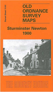
Sturminster Newton 1900

Sturminster Newton in 1900 in a fascinating series of reproductions of old Ordnance Survey plans in the Alan Godfrey Editions, ideal for anyone interested in the history of their neighbourhood or family. Selected towns in Great Britain and Ireland are covered by maps showing the extent of urban development in the last decades of the 19th and early 20th century.In this title: the map is double-sided to give maximum coverage. The main map shows the town centre, and coverage extends north to the workhouse and beyond to Twinwood Coppice, west to River Stour and Blackwater Bridge, east to Butts Pond, Rixon and Hosey Bridge. Features include station, Market Place, St Mary's church, The Lindens, Riverside Villas (where Thomas Hardy lived). On the reverse is a large extract from sheet
13.07 extending coverage south to Town Bridge and beyond to Bridge, Broad Oak, west to Newton, and south-east to part of Piddles Wood. Features here include remains of castle, Newton Farm, Glue Hill, Sturminster Mill.About the Alan Godfrey Editions of the 25
RIP - This product is no longer available on our network. It was last seen on 25.09.2019

This page now acts as a permanent archive for this product. Add more information using the comments box below to ensure it can still be found by future generations.

Use our search facility to see if it is available from an alternative contributor.
  • Availability: Out Of Stock
  • Supplier: Stanfords
  • SKU: 9786000005719
Availability: In Stock
£2.95

Product Description

Sturminster Newton in 1900 in a fascinating series of reproductions of old Ordnance Survey plans in the Alan Godfrey Editions, ideal for anyone interested in the history of their neighbourhood or family. Selected towns in Great Britain & Ireland are covered by maps showing the extent of urban development in the last decades of the 19th & early 20th century. In this title: the map is double-sided to give maximum coverage. The main map shows the town centre, & coverage extends north to the workhouse & beyond to Twinwood Coppice, west to River Stour & Blackwater Bridge, east to Butts Pond, Rixon & Hosey Bridge. Features include station, Market Place, St Mary's church, The Lindens, Riverside Villas (where Thomas Hardy lived). On the reverse is a large extract from sheet 13.07 extending coverage south to Town Bridge & beyond to Bridge, Broad Oak, west to Newton, & south-east to part of Piddles Wood. Features here include remains of castle, Newton Farm, Glue Hill, Sturminster Mill. About the Alan Godfrey Editions of the 25

Reviews/Comments

Add New

Price History

Vouchers

No voucher codes found.
Do you know a voucher code for this product or supplier? Add it to Insights for others to use.

Facebook

Jargon Buster

Pond - An area of water within a park or gardens
History - Anything that happens in the past. An acedemic subject.
Wood - A hard material found in trees. Used for tool making, fuel and construction.
Large - something that takes up more space than normal.
Mill - A building which can grind grain into flour.
Oak - A member of the beech tree family that has acorns growing on it.
Ideal - Something that satisfies a perfect criteria.
Family - A group of people that live together made up from parents and children.

Supplier Information

Stanfords
Stanfords was established in 1853 and opened their iconic Covent Garden flagship store in 1901. They have become the top retailer of maps, travel books and accessories in the UK and arguably offer the largest selection of maps and travel books worldwide. Famous names such as Captain Robert Falcon Scott, Ranulph Fiennes and Michael Palin have purchased from Stanfords. They now have a shop in Bristol and both stores together with other venues operate a calendar of events including talks, book signings and exhibitions. As a specialist map retailer, the map selection is comprehensive and includes road maps, street maps and walking maps from worldwide destinations, as well as a selection of world atlases and wall maps. Books include travel guides and travel literature. Stanfords also stock globes, from miniatures made of blue marble to magnificent floor-standing globes. The website features a selection of interesting articles on travel topics.
Page Updated: 2023-11-12 20:15:36

Community Generated Product Tags

Oh No! The productWIKI community hasn't generated any tags for this product yet!
Menu