More From Contributor
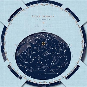
£7.99
Let your creativity run wild with Star Wars: The Force Awakens: Ultimate Stickerscapes. Containing more than 1, 000 reusable stickers of new heroes, villains, & vehicles, Star Wars: The Force Awakens: Ultimate Stickerscapes

Includes::
14 amazing backgrounds for you to create your own Star Wars: The Force Awakens scenes.

...
Archived Product
£14.99
This is the definitive guide to the characters, droids, aliens, & creatures of Star Wars: The Force Awakens. Beautiful photography & clear, authoritative text by Lucasfilm insider Pablo Hidalgo names & explains all the details of costumes, weapons, & accessories. It

Includes::
three exclusive, specially commissioned cutaway models produced by Industrial Light & Magic model maker John Goodson. (copyright) & Trademark 2015 Lucasfilm Ltd.

...
Archived Product
£7.99
With over 1, 000 colourful stickers, the Star Wars (TM) Vile Villains Ultimate Sticker Collection is fiendishly fun & packed full of spooky places, scary monsters & vile villains from the Star Wars galaxy, including Star Wars The Force Awakens. Add the infamous Star Wars villains such as Darth Vader, Count Dooku & Kylo Ren to the scenes inside or create your own dastardly deeds for them to carry out. Bursting with reusable, full-colour stickers to decorate your pencil case, bag & other belongings too. Cross over to the dark side... (c) & (TM) 2016 LUCASFILM LTD. ...
Archived Product
£6.99
Chewbacca, a notorious rebel ally, is wanted for crimes against the Empire. Not often seen without his partner-in-crime, Han Solo, this Wookiee has evaded capture on multiple occasions, due in no small part to the fastest freighter in the universe, the Millennium Falcon. Chewie, as he is more commonly known, has a sizeable bounty on his head. Can you find this furry criminal before other accomplished bounty hunters beat you to it? A uniquely illustrated search & find format, perfect for Star Wars fans young & old! Now in paperback! Look out for other Star Wars activity books: Star Wars: Art Therapy; Star Wars: Dot to Dot; Star Wars: Colouring by Numbers; Star Wars: Galaxy of Colouring; Star Wars Art of Colouring: The Force Awakens. ...
Archived Product
£11.95
Your Passport to the Universe The night sky is alive with many wonders--distant planets, vast star clusters, glowing nebulae, & expansive galaxies, all waiting to be explored. Let respected astronomy writer Philip Harrington introduce you to the universe in Star Watch, a complete beginner`s guide to locating, observing, & understanding these celestial objects. You`ll start by identifying the surface features of the Moon, the banded cloud tops of Jupiter, the stunning rings of Saturn, & other members of our solar system. Then you`ll venture out beyond our solar system, where you`ll learn tips & tricks for finding outstanding deep-sky objects from stars to galaxies, including the entire Messier catalog--a primary goal of every serious beginner. Star Watch features a detailed physical description of each target, including size, distance, & structure, as well as concise directions for locating the objects, handy finder charts, hints on the best times to view each object, & descriptions of what you`ll really see through a small telescope or binoculars & with the naked eye. Star Watch will transport you to the farthest depths of space--and return you as a well-traveled, experienced stargazer. ...
Archived Product
£9.99
” Fred Watson knows all about the madness that drives people to understand the Universe & unlock its secrets. Now you can join Australia`s best-known astronomer on a unique tour to unravel the mysteries of space & time. Take in primitive observatories in ancient Peru & the world`s largest atom-smasher in modern-day Switzerl&. See Pluto demoted from planetary status. Go behind headlines to find the truth about the Transit of Venus & the Higgs Boson. Meet some of science`s most colourful characters. In this light-hearted, informative & engaging book, Fred travels to some of those far-flung destinations as he weaves the epic story of humankind`s growing understanding of the Universe. It`s a grand adventure & the Professor is a witty, funny & knowledgeable companion. Come along on a journey that is sure to take you out of this world...” ...
Archived Product
£9.99
The southern part of the Stara Planina Mountains in south-eastern Serbia at 1:50, 000 from Geokarta, with hiking trails shown on a detailed, contoured topographic base with GPS coordinates, plus other tourist information. The map has contours at 20m intervals & colouring for forested areas, with additional symbols distinguishing deciduous or coniferous woodlands, & indicates boundaries of special protected areas. Local footpaths & bridle paths are marked & special overprint highlighting waymarked routes. Symbols highlight hotels, campsites & mountain refuges, shepherds’ huts, places of interest, etc. The map has latitude & longitude lines at intervals of 5’. All place names are given in the Latin alphabet only. Half of the reverse side has English language notes on the area, illustrated with colour photos, including recommendations for local tourist accommodation. ...
Archived Product
£7.99
Stara Planina Central: Uzana to Vratnik map at 1:50, 000 from Bulgarian publishers Domino, contoured & GPS compatible, with hiking trails, accommodation options including a list of local mountain refuges, etc. The map is double-sided & covers the mountains from just west of the Uzana massif, the geographical centre of Bulgaria, eastwards to the peak of Vratnik. Additional information provided in this title

Includes::
a street plan of Bozhentsi indicating hotels, cafes, etc, plus a plan of the ETAR architectural & ethnographic complex, both with names & text in Bulgarian only. Maps in the Domino series have contours (interval in most titles is 20m or 50m), enhanced by relief shading plus plenty of peak names & additional spot heights. Boundaries of national parks & other protected areas are marked. An overprint highlights both waymarked routes & unmaintained hiking trails. Although not specifically named on them, the maps can be used to follow local sections of the E3, E4 & E8 trans-European long-distance routes. Road network is graded according to width, indicates locations of petrol stations, &

Includes::
local country tracks & paths. Railway lines are shown with stations. Symbols mark locations of hotels & holiday homes, campsites, mountain refuges, shepherd’s huts & hunting lodges, as well as various places of interest & natural sites. Names of towns, villages & main topographic features are in both Cyrillic & Latin alphabet; smaller peaks or rivers & streams are in Cyrillic only. The maps have latitude & longitude grid at intervals of 5’. Map legend

Includes::
English. Most titles also include a list of local mountain refuges with contact details. To see other titles in this series please click on the series link.


...
Archived Product
£7.99
Stara Planina Central: Zlatitsa to Kalofer map at 1:50, 000 from Bulgarian publishers Domino, contoured & GPS compatible, with hiking trails, accommodation options including a list of local mountain refuges, etc. The map is double-sided & covers the mountains from just west of Ribaritsa & Zlatitsa eastwards beyond Kalofer to the peak of Zli Vrah. Maps in the Domino series have contours (interval in most titles is 20m or 50m), enhanced by relief shading plus plenty of peak names & additional spot heights. Boundaries of national parks & other protected areas are marked. An overprint highlights both waymarked routes & unmaintained hiking trails. Although not specifically named on them, the maps can be used to follow local sections of the E3, E4 & E8 trans-European long-distance routes. Road network is graded according to width, indicates locations of petrol stations, &

Includes::
local country tracks & paths. Railway lines are shown with stations. Symbols mark locations of hotels & holiday homes, campsites, mountain refuges, shepherd’s huts & hunting lodges, as well as various places of interest & natural sites. Names of towns, villages & main topographic features are in both Cyrillic & Latin alphabet; smaller peaks or rivers & streams are in Cyrillic only. The maps have latitude & longitude grid at intervals of 5’. Map legend

Includes::
English. Most titles also include a list of local mountain refuges with contact details. To see other titles in this series please click on the series link.


...
Archived Product
£7.99
Stara Planina Western: Belogradchik to Berkovita map at 1:50, 000 from Bulgarian publishers Domino, contoured & GPS compatible, with hiking trails, accommodation options including a list of local mountain refuges, etc. The map is double-sided & covers the mountains from the peak of Byala Voda near Belogradchik eastwards to just beyond Berkovita. Maps in the Domino series have contours (interval in most titles is 20m or 50m), enhanced by relief shading plus plenty of peak names & additional spot heights. Boundaries of national parks & other protected areas are marked. An overprint highlights both waymarked routes & unmaintained hiking trails. Although not specifically named on them, the maps can be used to follow local sections of the E3, E4 & E8 trans-European long-distance routes. Road network is graded according to width, indicates locations of petrol stations, &

Includes::
local country tracks & paths. Railway lines are shown with stations. Symbols mark locations of hotels & holiday homes, campsites, mountain refuges, shepherd’s huts & hunting lodges, as well as various places of interest & natural sites. Names of towns, villages & main topographic features are in both Cyrillic & Latin alphabet; smaller peaks or rivers & streams are in Cyrillic only. The maps have latitude & longitude grid at intervals of 5’. Map legend

Includes::
English. Most titles also include a list of local mountain refuges with contact details. To see other titles in this series please click on the series link.


...
Archived Product

Star Wheel Notebook

This hardcover journal features a planisphere (star wheel) on the cover, allowing users to rotate a disc to display the visible constellations in the sky for that specific date and time, any night of the year! With a handful of fascinating cosmic facts and visuals in the interior pages, this inspirational tool is easy to use and invites stargazers, nature enthusiasts, and creatives to explore and document the mysteries of the night sky. Note: Suitable for the Northern Hemisphere, 30-50 Degrees latitude (including U.S., Canada, England, Europe, N. China, and Japan).
RIP - This product is no longer available on our network. It was last seen on 25.09.2019

This page now acts as a permanent archive for this product. Add more information using the comments box below to ensure it can still be found by future generations.

Use our search facility to see if it is available from an alternative contributor.
  • External links may include paid for promotion
  • Availability: Out Of Stock
  • Supplier: Stanfords
  • SKU: 9781452162157
Availability: In Stock
£12.99

Product Description

This hardcover journal features a planisphere (star wheel) on the cover, allowing users to rotate a disc to display the visible constellations in the sky for that specific date & time, any night of the year! With a handful of fascinating cosmic facts & visuals in the interior pages, this inspirational tool is easy to use & invites stargazers, nature enthusiasts, & creatives to explore & document the mysteries of the night sky. Note: Suitable for the Northern Hemisphere, 30-50 Degrees latitude (including U.S., Canada, Engl&, Europe, N. China, & Japan).

Reviews/Comments

Add New

Intelligent Comparison

Oooops!
We couldn't find anything!
Perhaps this product's unique.... Or perhaps we are still looking for comparisons!
Click to bump this page and we'll hurry up.

Price History

Vouchers

No voucher codes found.
Do you know a voucher code for this product or supplier? Add it to Insights for others to use.

Facebook

Jargon Buster

Japan - An island in east Asia
Date - A day on a calendar
Date - A social activity whith a current or potential partner
star - A giant ball of plasma held together by gravity.
England - A country within the United Kingdom.
disc - A round flat object often used in reference to a computer storage media
Year - The time it takes the planet earth to orbit the sun. This takes around 365.25 days.
Year - 365 days (366 days in a leap year), the time taken for planet earth to make one full revolution around the sun.
Interior - The inside of something, usually what is not visible.

Supplier Information

Stanfords
Stanfords was established in 1853 and opened their iconic Covent Garden flagship store in 1901. They have become the top retailer of maps, travel books and accessories in the UK and arguably offer the largest selection of maps and travel books worldwide. Famous names such as Captain Robert Falcon Scott, Ranulph Fiennes and Michael Palin have purchased from Stanfords. They now have a shop in Bristol and both stores together with other venues operate a calendar of events including talks, book signings and exhibitions. As a specialist map retailer, the map selection is comprehensive and includes road maps, street maps and walking maps from worldwide destinations, as well as a selection of world atlases and wall maps. Books include travel guides and travel literature. Stanfords also stock globes, from miniatures made of blue marble to magnificent floor-standing globes. The website features a selection of interesting articles on travel topics.
Page Updated: 2023-11-12 20:15:36

Community Generated Product Tags

Oh No! The productWIKI community hasn't generated any tags for this product yet!
Menu