More From Contributor

£6.50
St. Louis in Missouri on an indexed street plan from Rand Mc Nally in their extensive range of maps covering cities in the United States. An inset provides a more detailed street plan of downtown St. Louis. Communities covered by this map include Arnold, Bellefontaine Neighbors, Crestwood, Creve Couer, Fenton, Florissant, Hazelwood, Kirkwood, Ladue, Sunset Hills, University City & Webster Groves. Rand Mc Nally street plans provide coverage of cities with their outer suburbs, clearly indicating main traffic arteries: highways (distinguishing between free & toll access), plus primary & secondary routes. Road numbers and/or names are clearly displayed & exit numbers are indicated. Locations of service & rest areas are marked & one way streets are shown. Longer streets are annotated with block numbers for easier identification of addresses. The maps show railway, bus &, where appropriate, metro stations. A range of symbols indicate various places of interest including cultural & academic institutions, various municipal facilities, golf courses, etc. The plans have extensive street indexes, supplemented by lists of points of interest, parks & recreational areas, shopping malls, stations, schools, etc. ...
Archived Product
£10.75
In this comprehensive guide to St Lucia, Guy Ellis introduces the reader to the many aspects of Saint Lucia, including a fascinating account of Saint Lucia`s once turbulent history. Saint Lucia is a Caribbean island which truly lives up to its travel brochure descriptions; an island of breath taking beauty with its miles of magnificent coastline, panoramic mountain views, lush vegetation & favourable climate. Its people, history, language & culture are a blend of the rich heritage of Africa, France & Engl&. It is the home of the only drive-in volcano in the world where the fascinating Sulphur Springs bubble. In recent years, while managing to retain its serenity & unspoilt natural beauty, along with the warmth of its hospitality, Saint Lucia has also succeeded in attracting a growing number of tourists by providing a wide range of facilities. ...
Archived Product
£8.99
Lush, tropical landscapes define this area of the Caribbean. From the low-key & traditional Dominica to the spectacular mountains of St Lucia, there is much to explore. This Footprint Handbook provides invaluable information on transport, accommodation, eating & entertainment to ensure that your trip

Includes::
the best of these accessible & rewarding Caribbean destinations.* Essentials section with useful advice on getting to & around St Lucia & Dominica.* Comprehensive, up-to-date listings of where to eat, sleep & relax.*

Includes::
information on tour operators & activities, from diving in turquoise waters to admiring the French colonial architecture.* Detailed maps for St Lucia & Dominica.* Slim enough to fit in your pocket. With detailed information on all the main sights, plus many lesser-known attractions, Footprint`s St Lucia & Dominica Handbook (
Includes: Fort-de-France (Martinique), Castries, Soufriere & Roseau) provides concise & comprehensive coverage of one of the Caribbean`s most undiscovered regions.


...
Archived Product
£15.25
Saint Lucia truly lives up to its reputation for outstanding beauty & for the friendliness of its people. In Saint Lucia: Portrait of an Isl&, Jenny Palmer’s superb photography takes us on a tour of the island to capture not only the wonders of the landscape but also the everyday lives of Saint Lucians. This is a book to savour before & during your visit & to take with you when you have to leave. ...
Archived Product
£7.99
Lush, tropical landscapes define this area of the Caribbean. From the low-key & traditional Dominica to the spectacular mountains of St Lucia, there is much to explore. Footprint Focus provides invaluable information on transport, accommodation, eating & entertainment to ensure that your trip

Includes::
the best of these accessible & rewarding Caribbean destinations. Essentials section with useful advice on getting to & around St Lucia & Dominica. Comprehensive, up-to-date listings of where to eat, sleep & relax.

Includes::
information on tour operators & activities, from diving in turquoise waters to admiring the French colonial architecture. Detailed maps for St Lucia & Dominica. Slim enough to fit in your pocket. With detailed information on all the main sights, plus many lesser-known attractions, Footprint Focus St Lucia & Dominica (
Includes: Fort-de-France (Martinique), Castries, Soufriere & Roseau) provides concise & comprehensive coverage of one of the Caribbean`s most undiscovered regions.


...
Archived Product
£6.99
St Lucia is one of the most luscious Caribbean islands, home to dramatic vistas, sweeping beaches & a lively Creole culture. Be inspired to visit by the brand new Insight Pocket Guide St Lucia, a concise, full-colour guide to this tropical paradise that combines lively text with vivid photography to highlight the best that St Lucia has to offer. Inside Insight Pocket Guide St Lucia:· Where To Go details all the key sights on this idyllic tropical isle, from the colonial architecture of Castries & iconic peaks of the Pitons to Anse Chastanet, popular with divers & snorkellers. St Lucia`s attractions are covered in detail, including its spectacular rainforest, fine beaches & colourful underwater treasures.· Top 10 Attractions gives a run-down of the best sights to take in on your trip, including the working plantation at Fond Doux Estate & the spectacular Diamond Falls.· Perfect Day provides an itinerary for one day on the isl&.· What To Do is a snapshot of ways to spend your spare time, from watersports & cycling to walking rainforest trails & birdwatching, plus nightlife.· Essential information on St Lucia`s culture, including a brief history of the isl&.· Eating Out covers the island`s best cuisine.· Curated listings of the best hotels & restaurants.· A-Z of all the practical information you`ll need. ...
Archived Product
£13.50
Wall map version of a lovely indexed road map of St. Lucia, with street plans of central Castries & the holiday complex at Anse Chastanet. Bright altitude colouring & vivid relief shading provide an excellent picture of the islands topography. Mangroves & coral reefs are marked. Road network

Includes::
minor local roads & tracks. The map also shows the country’s administrative divisions. Protected nature areas & animal watching locations are marked & the map highlights hotels & tourist accommodation, waymarked hiking trails, sites for scuba diving, watersports & deep see fishing, golf courses, various places of interest & natural curiosities, etc. The map has a 2’ latitude/longitude grid & is indexed. Also included are street plans of central Castries & the holiday complex at Anse Chastenet, plus an overview map of the southern Caribbean.

...
Archived Product
£20.00
St Martin`s has a long history stretching back more than eight hundred years
- during which its life has rarely been dull. A place
...
Archived Product
£3.50
St Marylebone area of London in 1870 in a series of exceptionally detailed reproductions of old Ordnance Survey street plans for areas of larger cities which have undergone substantial redevelopment in the late 19th or the early 20th century, published in the Alan Godfrey Editions. The plans, printed in back & white, have been taken from the original Ordnance Survey mapping at 1:1, 056 & reproduced at 1:1, 760 – the equivalent of 36 inches (or one yard) to a mile. The maps provide an unrivalled, house-by-house picture of streets & individual buildings with inner courtyards, outbuildings, pavements, covered passages, etc. Many important institutions are named; within the National Galley on Trafalgar Square even the individual rooms (the map is from 1871, so no French Impressionists as yet!). On the reverse are historical notes about the area covered by the map, plus extracts from contemporary street directories. These maps provide a fascinating addition to Alan Godfrey’s huge series of some 2, 000 titles presenting reproductions of street plans at taken from the Ordnance Survey mapping at 1:2, 500 (25” to 1 mile) & reprinted at about 15 inches to one mile (1:4, 340). ...
Archived Product
£2.95
St Michael's & Aigburth Vale in 1908 in a fascinating series of reproductions of old Ordnance Survey plans in the Alan Godfrey Editions, ideal for anyone interested in the history of their neighbourhood or family. Selected towns in Great Britain & Ireland are covered by maps showing the extent of urban development in the last decades of the 19th & early 20th century. In this title: the map covers the area of south Liverpool around St Michael's, Aigburth Vale & the southern part of Sefton Park. Coverage stretches from the Jericho Shore eastward to Gladeville Road, & from Livingston Drive southward to Otterspool House. Features include the western part of Mossley Hill, St Anne's church, tramways, Aigburth Lodge, Otterspool Farm, St Charles RC church, St Augustine's Home, Corporation Engineering Works, Cheshire Lines Railway with Otterspool & St Michael's stations, St Michael's Hamlet, Knott's Hole, West Dingle, Fulwood Park etc. On the reverse is a selection of street directory entries for the area. About the Alan Godfrey Editions of the 25 ...
Archived Product

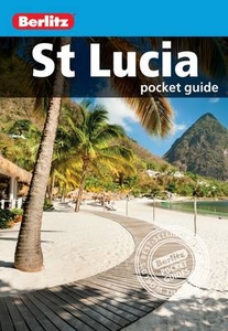
St Lucia Pocket Guide

Berlitz Pocket Guide St Lucia is a concise, full-colour travel guide that combines lively text with vivid photography to highlight the very best that this beautiful country has to offer. Easy-to-read sections cover the island`s rich, and at times turbulent, history and vibrant culture, as well as entertainment, food and drink. There are easy-to-follow routes provided within this guide, or you can simply pick the sights that interest you; in either case all main sights, including those particularly good for water sports, are cross-referenced on detailed full-colour maps throughout, providing instant orientation. Full-colour photographs provide a visual introduction to this alluring destination and also make this guide a great souvenir after your trip. Practical travel information
covers transport, accommodation, restaurants and more so you have all the information you need at your fingertips, including essential contact details. Small in size but big on detail, this guide is both durable and ultra portable, so it can go wherever you go.
RIP - This product is no longer available on our network. It was last seen on 25.09.2019

This page now acts as a permanent archive for this product. Add more information using the comments box below to ensure it can still be found by future generations.

Use our search facility to see if it is available from an alternative contributor.
  • External links may include paid for promotion
  • Availability: Out Of Stock
  • Supplier: Stanfords
  • SKU: 9781780048307
Availability: In Stock
£5.99

Product Description

Berlitz Pocket Guide St Lucia is a concise, full-colour travel guide that combines lively text with vivid photography to highlight the very best that this beautiful country has to offer. Easy-to-read sections cover the island`s rich, & at times turbulent, history & vibrant culture, as well as entertainment, food & drink. There are easy-to-follow routes provided within this guide, or you can simply pick the sights that interest you; in either case all main sights, including those particularly good for water sports, are cross-referenced on detailed full-colour maps throughout, providing instant orientation. Full-colour photographs provide a visual introduction to this alluring destination & also make this guide a great souvenir after your trip. Practical travel information covers transport, accommodation, restaurants & more so you have all the information you need at your fingertips, including essential contact details. Small in size but big on detail, this guide is both durable & ultra portable, so it can go wherever you go.

Reviews/Comments

Add New

Intelligent Comparison

Oooops!
We couldn't find anything!
Perhaps this product's unique.... Or perhaps we are still looking for comparisons!
Click to bump this page and we'll hurry up.

Price History

Vouchers

No voucher codes found.
Do you know a voucher code for this product or supplier? Add it to Insights for others to use.

Facebook

Jargon Buster

water - A chemical substance. Chemical formula H2O.
History - Anything that happens in the past. An acedemic subject.
Entertainment - Something that provides amusement
Colour - The categorised spectrum of light visable to humans
Size - is the measurement of how big an object is in space.
Small - something that takes up less space than normal.
Accommodation - A room in which someone can live in, for example in a hotel
Practical - Weather a task is easy to carry out and realistically succeed.
Pocket - A bag shaped insert in clothing used to carry items
Transport - Something that carries people or goods.

Supplier Information

Stanfords
Stanfords was established in 1853 and opened their iconic Covent Garden flagship store in 1901. They have become the top retailer of maps, travel books and accessories in the UK and arguably offer the largest selection of maps and travel books worldwide. Famous names such as Captain Robert Falcon Scott, Ranulph Fiennes and Michael Palin have purchased from Stanfords. They now have a shop in Bristol and both stores together with other venues operate a calendar of events including talks, book signings and exhibitions. As a specialist map retailer, the map selection is comprehensive and includes road maps, street maps and walking maps from worldwide destinations, as well as a selection of world atlases and wall maps. Books include travel guides and travel literature. Stanfords also stock globes, from miniatures made of blue marble to magnificent floor-standing globes. The website features a selection of interesting articles on travel topics.
Page Updated: 2023-11-12 20:15:36

Community Generated Product Tags

Oh No! The productWIKI community hasn't generated any tags for this product yet!
Menu