
 United Kingdom
 France
 Germany
 Netherlands
 Sweden
 USA
USA
 Italy
Italy
 Spain
Spain
More From Contributor


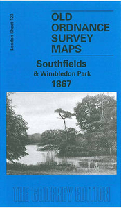
Southfields And Wimbledon Park 1867
Southfields and Wimbledon Park in 1867 in a fascinating series of reproductions of old Ordnance Survey plans in the Alan Godfrey Editions, ideal for anyone interested in the history of their neighbourhood or family. Two versions cover this area, extending from Putney Heath eastward to Merton Road, and from Wincanton Road and Brathway Road southward to Ryfold Road and St Luke`s church. Development of the `Wimbledon Park` Estate followed the sale of the land by the 4th Earl Spencer to John Augustus Beaumont in 1846. The two maps are quite different:By the 1860s an estate of `stately villas` had been built. These are shown on the 1867 map in their leafy grounds, while further east `South Field` is largely rural, and aspects of Capability Brown`s park can be seen. This is a most
attractive map, with a few large houses shown at the top on Putney Heath: Fireproof House, Highlands, Bristol House. At the foot is an area called Parkside. Fine villas line the east side of the Heath - Belmont, Albermarle Lodge, etc - and also on Inner Park Road and Victoria Road. Further east `South Field` is almost entirely rural, while to the south are remnants of Capability Brown`s landscaping, with The Lake. The short directory Wimbledon Park lists the gentry who lived here. The Wimbledon & Fulham railway arrived in 1889 and a much more routine suburb developed around Southfields station. By the time of the 1913 map the term `Wimbledon Park` is shown referring only to the remaining parkland at the foot of the map. East of the railway are many streets of terraces, but the
villas of Wimbledon Park still, for the time being, survive.About the Alan Godfrey Editions of the 25” OS SeriesSelected towns in Great Britain and Ireland are covered by maps showing the extent of urban development in the last decades of the 19th and early 20th century. The plans have been taken from the Ordnance Survey mapping and reprinted at about 15 inches to one mile (1:4, 340). On the reverse most maps have historical notes and many also include extracts from contemporary directories. Most maps cover about one mile (1.6kms) north/south, one and a half miles (2.4kms) across; adjoining sheets can be combined to provide wider coverage.FOR MORE INFORMATION AND A COMPLETE LIST OF ALL AVAILABLE TITLES PLEASE CLICK ON THE SERIES LINK.

Product Description
Reviews/Comments
Add New
Vouchers
No voucher codes found.
Do you know a voucher code for this product or supplier? Add it to Insights for others to use.
Do you know a voucher code for this product or supplier? Add it to Insights for others to use.
 Denmark