More From Contributor
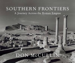
£14.99
One name above all others has become associated with walking in the Lake District: Alfred Wainwright, whose seven-volume Pictorial Guide to the Lakeland Fells, first published in 1955-66, has become the definitive guidebook. Wainwright`s meticulously h&-drawn maps, diagrams & drawings take walkers up the 214 principal hills & mountains of the Lake District, describing the main routes of ascent from different starting points, as well as lesser-known variants, showing the summit viewpoint panoramas & the ridge routes that can be made to create longer walks. Every page combines words & illustrations to present the routes in a way that is original, visually appealing & easy to follow. This new edition of Wainwright`s Walking Guide to the Lake District Fells has been comprehensively revised. Paths, maps, diagrams & route descriptions have been checked & corrected throughout. These revisions have been undertaken by writer & designer Clive Hutchby, author of The Wainwright Companion. The Southern Fells, Book Four of Wainwright`s Walking Guide, covers the great mountain systems of Scafell-Bowfell & the Coniston fells &

Includes::
some of Wainwright`s own favourite ascents, such as Scafell Pike, Bowfell & Crinkle Crags.

...
Archived Product
£14.95
The Southern Fells is part of a planned 8-part Cicerone series of Lakeland Fellranger volumes written by Mark Richards that provide a comprehensive survey of the fells of the English Lake District. This volume covers the Southern Fells which are defined to the north by the ‘lost’ Roman Road that crossed Hardknott & Wrynose passes & led from Eskdale into Little Langdale. The fells then run south on both sides of the river Duddon with the Coniston fells to the east. The area begins upon harter Fell & ends remotely upon the coastal reaches of Black Combe. The guide reveals the contemporary pattern of fell approaches, ascents & ridge routes & gives walkers the flexibility to choose between the well-known peaks & the more hidden areas of the District. The guide is structured into 23 sections with each Fell in the area having its own dedicated chapter. Each section describes the variety of routes on the fell & has a ‘ Starting Points’ information box providing details on location, Grid Reference, Parking facilities & any local bus stops. There are also fellscape diagrams & detailed summit panoramas that complement the written text. A detailed introduction introduces the Lake District to readers & provides information on safety in Lakeland & a note on the ‘ Fix the Fells’ campaign to repair some of the most damaged fell paths. There is also an advisory note from the National Park authorities on responsible walking. Four graphic projections of the range also give the reader an overall impression of the area. Detailed route descriptions are accompanied by extracts from cartographic specialists Harvey mapping the route, as well as colour photographs illustrating some of the highlights of one of England’s most beautiful & popular walking destinations. ...
Archived Product
£9.50
Indexed, waterproof & tear-resistant road map of the southern quarter of France, from the Atlantic to the Alps, with coverage extending northwards to line from Bordeaux to the Ecrins & Queyras Alpine Parks. The map, published by Reise Know-How as part of their highly acclaimed World Mapping Project, is double-sided to provide the best balance between a good scale & a convenient size sheet. The area ...
Archived Product
£9.99
Southern France on a double-sided road map 1:465, 000 approx. from the National Geographic Society printed on light, waterproof & tear-resistant synthetic paper. Cartographic information provided by the German publishers Reise Know-How is presented here in the overall style of the NGS Adventure maps. The map divides southern France east/west, with no overlap between the sides. Topography is shown by relief shading & contours at 200m intervals, plus names of the main mountain ranges, etc. Boundaries of national or regional parks & other protected areas are marked. Road network is clearly presented, although without indicating full/partial motorway interchanges or services; driving distances are shown on main & on most secondary routes. Railway lines are included, if not always easy to see given the density of other detail, & domestic airports are marked. Symbols highlight a selection of the county’s numerous places of interest. Latitude & longitude lines are drawn at 30’ intervals & the map has an index of place names.PLEASE NOTE: to ensure regular supplies & faster delivery to our customers we keep as regular stock the original Reise Know-How edition whilst the NGS version can be ordered on request. ...
Archived Product
£6.99
Insight Travel Map Southern France: This detailed travel map is all you need to plan your route & navigate your way around Southern France, & also

Includes::
area highlights, top attractions, places of interest, streetplans, & a fabulous free app.· Travel Map Southern France is drawn to a scale of 1:800 000 & shows the entire country, complete with a comprehensive index· Ideal for planning your route, & on-the-road-exploring·

Includes::
free app, with top travel tips, & additional area highlights· Features detailed street plans of Bordeaux, Cannes, Lyon, Marseille & Nice· Outlines Top Attractions & places of interest, including national parks, nature reserves & heritage sites· Handy distance indicators, located in the margin, give distances to the nearest town & major locations· Shows roads, rail networks & ferry routes· Pictorial symbols allow for instant, easy recognition· Detailed topography, through the use of relief shading, with mountain ranges named, & peak heights given· Legend shown in eight languages


...
Archived Product
£12.99
Southern Götaland at 1:250, 000 in a series of GPS compatible touring road maps of Sweden produced by Norstedts Kartförlaget in cooperation with the country’s national survey organization & highlighting places of interest, campsites, recreational facilities, etc. The series covers southern & central Sweden at 1:250, 000, with the north at 1:400, 000. Spot heights & relief colouring in mountainous areas present the terrain; the maps also distinguish between forested & open areas, & show marshes & glaciers. Detailed road classification

Includes::
what is confusingly described in the map legend as “private” roads; these are unsurfaced roads, open to the general public but simply privately maintained. Selected hiking trails are also marked. Railway lines are shown with stations, car ferry routes & local airports are indicated. The maps also show boundaries of local administrative units, national parks & other protected areas, plus restricted entry military zones. Tourist information

Includes::
places of interest, campsites & youth hostels, golf courses, sport & recreational facilities, etc. Latitude & longitude lines are shown at intervals of 10`. Map legend

Includes::
English. To see other titles in this series please click on the series link.


...
Archived Product
£16.95
The Scottish Mountaineering Club District Guide to the Southern Highlands is a comprehensive guide to hill-walking & climbing in the region. The area covered by this volume extends from the Central Belt of Scotland northwards to the line of the River Awe, Glen Orchy, the southern edge of the Moor of Rannoch, Loch Rannoch & Loch Tummell. From there the eastern boundary follows the rivers Tummel & Tay to the sea, &

Includes::
the Kingdom of Fife. On the west the area is bounded by the coastline from the Firth of Clyde round the Cowal Peninsula to Kintyre & up the west coast to Oban & the lower reaches of Loch Etive. Each chapter begins by providing information on available maps, principle hill & mountain groups with elevation details, access, transport, accommodation & a general description of the isl&. Following this, detailed descriptions are given for the areas hills & mountains, walking on the isl&, as well as rock climbing opportunities. Each chapter is accompanied by hand drawn maps & is illustrated throughout with photographs. An introductory section provides general information on the region as a whole, including access, transport, accommodation, weather, mountain rescue, geology, natural history & social history. About this series These sturdy hardbacked volumes could be said to be the definitive guides to the mountaineering districts of Scotl&. An enormous amount of detail is included in these titles. Each chapter covers a specific area, with a detailed diagrammatic map & a separate description for each of the principle hills, including ascent & descent instructions. Extensive additional information is included for walkers, cavers, geologists & climbers. There is also advice on public transport & accommodation.

...
Archived Product
£15.95
Waterproof mountain map of Southern Highlands from Harvey at 1:40, 000, with a geological map of the region on the reverse, as well as an extension to the main map covering Ben Cruachan & Ben Vorlich & additional advice on navigating the region safely. *MAIN MAP:* Topography is shown through clear altitude shading, spot heights, contours at 15m intervals, & index contours at 75m intervals. A variety of symbols are used to show terrain detail, such as caves/mines, major & climbing crags, shafts, sinkholes, cairns, & large boulders. The map is GPS compatible, with the National Grid overprinted on the cartography. Rights of way shown include tracks, long distance & intermittent paths. Road detail

Includes::
minor, residential & forest roads; railway lines & stops are marked, as are chairlifts & ski tows. Points of interest & facilities such as campsites, information points, & mountain rescue post are prominently highlighted.*GEOLOGICAL MAP:* The reverse shows a geological map of the region from the British Geological Survey, with detailed relief shading & colours used to denote different types of rock. There is additional written geological information, as well as a geological timeline of the region.*ADDITIONAL INFORMATION:* There is also information on mountain incident & first aid, navigating the region safely & tips for using maps & compasses. Useful contact numbers are provided. Additional information text is in English & Welsh. Printed on tough, hard-wearing polyethylene, the map is waterproof, tear-resistant, & comes in a clear plastic wallet.

...
Archived Product
£9.95
This essential travel guide to Southern India`s varied heritage covers all the major Buddhist, Hindu, Muslim & European historical monuments & sites in Maharashtra, Goa, Karnataka, Andhra Pradesh, Tamil Nadu & Kerala. There are amazing descriptions of forts & palaces, temple architecture, sculpture & painting, mosques & tombs, churches & civic buildings. Plan trips by using the travel-friendly itineraries, accompanied by useful location maps. This essential travel guide contains comprehensive coverage of the region`s cities & monuments, museums, & archaeological sites. It

Includes::
all the major sites the great port cities of Mumbai, Chennai & Kochi; the citadels of Golconda, Vijaynagara & Gingee; the rock-cut sanctuaries at Ajanta & Ellora; the temples at Badami, Halebid & Thanjuvar; the mosques of Hyderabad & Bijapur; & the cathedrals at Goa & hundreds of less well-known places.

...
Archived Product
£29.99
With its wide open seas, plentiful, secluded anchorages, beautiful scenery, & interesting navigational challenges, the southern coast of Ireland is nothing short of a yachtsman`s paradise. The ideal onboard guide to traveling these waters, Southern Ireland Cruising Companion

Includes::
detailed descriptions of every entrance, harbor, anchorage & service in the area, advice on the weather, tides, & passage planning, plus tips on local attractions such as museums, galleries, restaurants, & bars. Loaded with stunning aerial photos & charts, the book gives readers a real flavor of the local culture & history. Readers can also subscribe to regular updates on this cruising region by subscribing on www.wileynautical.com/updates

...
Archived Product

Southern Frontiers

Don McCullin`s reputation as the greatest photographer of conflict has been replaced in recent years with an image of McCullin as the great traveller. He is now as familiar with the remoter parts of the globe as he was once accustomed to life in the war zone. His most ambitious journey has been to explore the fringes of the Roman empire. ”Southern Frontiers” is divided into two parts. The first part, ”The Levant”, includes the ruins of Baalbek in the Lebanon, Palmyra in Syria and Jirash in Jordan. The second part, ”The Moghreb”, covers a sweeping journey through the North African coastal countries Morocco, Algeria, Tunisia and Libya, where he has photographed the great ruins of Leptus Magna. McCullin`s photographs, taken on a large format camera, are evocative of the
views of distinguished nineteenth-century predecessors who came with sketchbooks and paints. The book is produced in an appropriate large album format. Texts on each of the sites have been written by Barnaby Rogerson, an authority on the Roman empire. The book will include an introduction by McCullin himself.
RIP - This product is no longer available on our network. It was last seen on 25.09.2019

This page now acts as a permanent archive for this product. Add more information using the comments box below to ensure it can still be found by future generations.

Use our search facility to see if it is available from an alternative contributor.
  • External links may include paid for promotion
  • Availability: Out Of Stock
  • Supplier: Stanfords
  • SKU: 9780224087087
Availability: In Stock
£50.00

Product Description

Don Mc Cullin`s reputation as the greatest photographer of conflict has been replaced in recent years with an image of Mc Cullin as the great traveller. He is now as familiar with the remoter parts of the globe as he was once accustomed to life in the war zone. His most ambitious journey has been to explore the fringes of the Roman empire. ” Southern Frontiers” is divided into two parts. The first part, ” The Levant”,

Includes::
the ruins of Baalbek in the Lebanon, Palmyra in Syria & Jirash in Jordan. The second part, ” The Moghreb”, covers a sweeping journey through the North African coastal countries Morocco, Algeria, Tunisia & Libya, where he has photographed the great ruins of Leptus Magna. Mc Cullin`s photographs, taken on a large format camera, are evocative of the views of distinguished nineteenth-century predecessors who came with sketchbooks & paints. The book is produced in an appropriate large album format. Texts on each of the sites have been written by Barnaby Rogerson, an authority on the Roman empire. The book will include an introduction by Mc Cullin himself.

Reviews/Comments

Add New

Intelligent Comparison

Oooops!
We couldn't find anything!
Perhaps this product's unique.... Or perhaps we are still looking for comparisons!
Click to bump this page and we'll hurry up.

Price History

Vouchers

No voucher codes found.
Do you know a voucher code for this product or supplier? Add it to Insights for others to use.

Facebook

Jargon Buster

Camera - An electronic device used for taking photographs
Large - something that takes up more space than normal.

Supplier Information

Stanfords
Stanfords was established in 1853 and opened their iconic Covent Garden flagship store in 1901. They have become the top retailer of maps, travel books and accessories in the UK and arguably offer the largest selection of maps and travel books worldwide. Famous names such as Captain Robert Falcon Scott, Ranulph Fiennes and Michael Palin have purchased from Stanfords. They now have a shop in Bristol and both stores together with other venues operate a calendar of events including talks, book signings and exhibitions. As a specialist map retailer, the map selection is comprehensive and includes road maps, street maps and walking maps from worldwide destinations, as well as a selection of world atlases and wall maps. Books include travel guides and travel literature. Stanfords also stock globes, from miniatures made of blue marble to magnificent floor-standing globes. The website features a selection of interesting articles on travel topics.
Page Updated: 2023-11-12 20:15:36

Community Generated Product Tags

Oh No! The productWIKI community hasn't generated any tags for this product yet!
Menu