More From Contributor
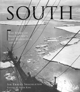
£16.99
`I will never forget the first time I read Jenny Zhang.. .I was stunned, moved &
- quite frankly
- a little jealous` Lena Dunham

...
Archived Product
£11.50
Topographic survey of France at 1:25, 000 in IGN`s excellent TOP25 / Série Bleue series. All the maps are GPS compatible, with a 1km UTM grid plus latitude & longitude lines at 5’ intervals. Contours are at 5m intervals except for mountainous areas where the maps have contours at 10m intervals, vividly enhanced by hill shading & graphics for rocky terrain. Colouring with graphics indicates different types of vegetation or land use (deciduous or coniferous forests, moors, orchards, vineyards, etc). PLEASE NOTE: coverage of France at this scale is currently being revised – the format & the presentation of each title are indicated by the letters at the end of its Sheet Reference number (e.g. 0416ET, 3531ETR, 1923SB, etc.)MAPS WITH FULL TOURIST OVERPRINT & AN ENGLISH MAP LEGEND: all TOP25 maps & the SB editions of Série Bleue have an overprint highlighting waymarked walking trails including long-distance GR routes &, where appropriate, ski routes. Symbols indicate campsites, gîtes d’etape, refuges, equestrian centres & other recreational facilities or sites, tourist information centres, cultural heritage, etc. Towns & locations of particular interest are highlighted.- ET or OT = single-sided TOP25 map covering approx. 29x 21 km / 18x 13 miles.- ETR or OTR = waterproof & tear resistant TOP25 map covering the same area as the corresponding ET or OT number, but double-sided, printed on a smaller size sheet with a good overlap between the sides.- SB = Série Bleue map with full tourist overprint; these maps, first introduced in summer 2014, each cover approx. 29x 24km / 18x 15 miles.SÉRIE BLEUE maps with numbers ending in E (Est) or O (Ouest): most editions now indicate the GR routes, but do not show any other tourist information. Map legend is in French only. Each map covers approx. 14x 20km / 9x 12 miles. ...
Archived Product
£17.99
Topographic survey of Portugal at 1:50, 000 from the Instituto Geográfico do Exército, the country’s military survey organisation. The maps have contours at 20m intervals & in addition to the standard features shown on topographic mapping at this scale also indicate various types of terrain or vegetation (s&, terraces, rocks, woodlands, vineyards, etc). Each sheet covers an area of 32 x 20km (20 x 12.5 miles approx). The maps have a 1-km UTM grid plus latitude & longitude coordinates for the map corners. Map legend & a glossary of terms used on the maps include English.EDITION DATES: most titles in this series date from 1990s or later. To see all the titles in this series please click on the series link. ...
Archived Product
£17.99
Topographic survey of Portugal at 1:50, 000 from the Instituto Geográfico Português, the country’s civilian survey organisation. The maps have contours at 25m intervals & in addition to the standard features shown on topographic mapping at this scale also indicate various types of vegetation (vineyards, olive groves, etc). Each sheet covers an area of 32 x 20km (20 x 12.5miles approx). The maps have latitude & longitude margin ticks at 1’ intervals & UTM coordinates for the map corners – each sheet also shows conversion details from BBLx (Bessel-Bonnie system, Datum Lisbon) to UTM. Map legend is in Portuguese only.EDITION DATES: most titles in this series have now been updated in the 1990s or later. To see all the titles in this series please click on the series link. ...
Archived Product
£14.99
A concise, authoritative & fully illustrated survey of Antarctic exploration in the early part of the 20th century, focusing on the race to the South Pole, including the epic expeditions of Robert Falcon Scott & Ernest Shackleton. This book retells in vivid detail the dramatic story of the struggle to reach the South Pole & is organized in 7 chapters; including chapters on the race to the Pole, food & supplies used at the time, the subsequent filming of the stories of the explorers & detailed information on each of the major expeditions.
Includes: many contemporary images from expedition photographers & color pictures of selected artifacts & memorabilia from the various expeditions
...
Archived Product
£9.99
As the First World War broke out in Europe in 1914, Sir Ernest Shackleton sailed to Antarctica, with the King & government’s blessing. Intent on making the first ever trans-Antarctic crossing, South! is Shackleton’s first-hand account of the epic expedition, which he described as ‘the last great journey on earth’. During the journey their ship, the Endurance, became trapped by ice & was crushed, forcing the men to survive in & escape from one of the world’s most hostile environments. With no hope of rescue, Shackleton & four others set sail in a small open boat on a 600-mile crossing to South Georgia – a journey now viewed as one of the masterpieces of marine navigation. Shipwrecked on the uninhabited side of the isl&, they were forced into making the first ever winter crossing of the territory, all the time threatened by brutal cold & hunger, & hoping beyond hope that they would encounter some sort of civilization on the other side. South! made Shackleton’s name as an explorer & the dramatic story, one of the most astonishing feats of Polar escapology, remains as enthralling as when it was first published in 1919. ...
Archived Product
£3.99
OS Tour Map no. 11, covering South & Mid Wales (De a Chanolbarth Cymru) at 1:175, 000, extending to Barmouth, Dolgellau & Welshpool / Y Trallwng in the north. Insets show town navigation maps of Cardiff / Caerdydd, Newport / Casnewydd, Swansea / Abertawe, Aberystwyth, Brecon / Aberhonddu, Monmouth / Trefynwy, & Tenby / Dinbych-y-Pysgod. Edition D; Publication date June 2010 About this series:A series of Ordnance Survey ...
Archived Product
£4.99
South & Mid Wales presented at 1:175, 000 on an indexed Ordnance Survey Tour Map with extensive tourist information including an index of selected places of interest. Town navigation maps highlight main traffic arteries plus principal sights & facilities in Aberystwyth, Brecon, Cardiff, Newport Monmouth, Swansea & Tenby. PLEASE NOTE: rather than indicating national & regional cycle routes & national trails on the map itself, this information is provided on a separate inset. The index lists both English & Welsh place names. Current edition of this title was published in February 2016. To see the list of titles in this series please click on the series list – Ordnance Survey’s Tour maps have extra clear, uncluttered cartography. Topography is shown by altitude colouring & relief shading, plus names of local hill or mountain ranges & heights of important peaks. Additional colouring indicates woodlands; boundaries of National Parks or designated Areas of Outstanding Natural Beauty are also marked. Road information very clearly distinguishes between different types of roads, from motorways to small local roads, with distances on main routes. Scenic routes are highlighted; motorway services, tolls, gradients on steep roads & level crossings are marked & towns used in motorway signs as Primary Route Destinations are indicated. Railway lines are shown with stations &, where appropriate, ferry routes are marked. Roads which are part of the national or regional cycle network are highlighted & shown with route numbers; the maps also show the National Trail long-distance hiking paths. An extensive range of symbols indicate various places of interest, including campsites/caravan parks & youth hostels/bunkhouses, historic buildings, sport & recreational facilities, country pubs, etc. The maps have lines of the British National Grid. The place names index is supplemented by a list of selected places of interest plus, in most titles, of market days and/or farmers markets. The maps also include city navigation maps, highlighting main traffic arteries, car parks, principal sights & facilities, etc. For more information please see descriptions & coverage images of individual maps. ...
Archived Product
£8.99
As war clouds darkened over Europe in 1914, a party led by Shackleton set out to make the first crossing of the entire Antarctic continent via the Pole. But their initial optimism was short-lived as ice floes closed around their ship, gradually crushing it & marooning 28 men on the polar ice. Alone in the world's most unforgiving environment, Shackleton & his team began a brutal quest for survival. & as the story of their journey across treacherous seas & a wilderness of glaciers & snow fields unfolds, the scale of their courage & heroism becomes movingly clear. ...
Archived Product
£3.50
South Acton & Gunnersbury in 1893 in a fascinating series of reproductions of old Ordnance Survey plans in the Alan Godfrey Editions, ideal for anyone interested in the history of their neighbourhood or family. Two versions of this map have been published to show how the area developed across the years. The western half of the map is dominated by Gunnersbury Park, including Gunnersbury House. The eastern half of the map is very built up, with South Acton, the Mill Hill Park estate &, further down, Acton Green. Acton High Street is in the north corner. Several railways cross the map, including the North & South Western Junction & the District`s Ealing Extension. Stations include South Acton, Chiswick Park & Acton Green, & Mill Hill Park (later Acton Town). Other features include Fairlawn House, All Saints church, Bollo Bridge Road, Heathfield Lodge, Berrymead Priory (here Constitutional Club), Elm Grove (until 1892 the Royal India Asylum). St Mary`s parish church is at the extreme top of the map. The 1935 version

Includes::
a selection of contemporary street directories for Avenue Road, Bollo Bridge Road, Gunnersbnury Avenue, Gunnersbury Lane, Osborne Road. About the Alan Godfrey Editions of the 25” OS Series: Selected towns in Great Britain & Ireland are covered by maps showing the extent of urban development in the last decades of the 19th & early 20th century. The plans have been taken from the Ordnance Survey mapping & reprinted at about 15 inches to one mile (1:4, 340). On the reverse most maps have historical notes & many also include extracts from contemporary directories. Most maps cover about one mile (1.6kms) north/south, one & a half miles (2.4kms) across; adjoining sheets can be combined to provide wider coverage.FOR MORE INFORMATION & A COMPLETE LIST OF ALL AVAILABLE TITLES PLEASE CLICK ON THE SERIES LINK.

...
Archived Product

South

Shackleton`s South is one of the great books of exploration. Written by a national hero, about what he called `the last great journey on earth` - his Antarctic expedition in which his ship, the Endurance, was crushed by the ice, and he and his men made a 600-mile trek across ice and ocean to solid land. They then embarked on a 700-mile journey in an open boat to South Georgia, followed by an epic crossing of the uncharted mountains of that island. His account is superbly written, and the book has never ceased to enthral readers since it was first published in 1919. Since that time, however, Shackleton`s life - and his account of the expedition - have been dramatically revalued by scholars and biographers, and it emerges that South conceals much of the truth about his great feat.
In this edition Peter King, who has examined the latest research on the entire episode, presents in his additional notes a much more detailed picture of what really occurred.The major defects in Shackleton`s organisation, the inadequate finances, the lack of training provided for his crew in the handling of skis, sledges and dogs, Shackleton`s personal problems (which were considerable), the failure to provide proper supplies of food - these and many other details are explained, and give a fascinating background to what remains a magnificent drama of leadership. In addition, the book contains over a hundred beautifully produced photographs by Frank Hurley, the official photographer of the expedition as well as other contemporary illustrations. The explanatory captions, and the
maps charting the course of the expedition, enable readers to follow Shackleton`s account almost as it they were present themselves.
RIP - This product is no longer available on our network. It was last seen on 25.09.2019

This page now acts as a permanent archive for this product. Add more information using the comments box below to ensure it can still be found by future generations.

Use our search facility to see if it is available from an alternative contributor.
  • External links may include paid for promotion
  • Availability: Out Of Stock
  • Supplier: Stanfords
  • SKU: 9780712664127
Availability: In Stock
£18.99

Product Description

Shackleton`s South is one of the great books of exploration. Written by a national hero, about what he called `the last great journey on earth`
- his Antarctic expedition in which his ship, the Endurance, was crushed by the ice, & he & his men made a 600-mile trek across ice & ocean to solid l&. They then embarked on a 700-mile journey in an open boat to South Georgia, followed by an epic crossing of the uncharted mountains of that isl&. His account is superbly written, & the book has never ceased to enthral readers since it was first published in 1919. Since that time, however, Shackleton`s life
- & his account of the expedition
- have been dramatically revalued by scholars & biographers, & it emerges that South conceals much of the truth about his great feat. In this edition Peter King, who has examined the latest research on the entire episode, presents in his additional notes a much more detailed picture of what really occurred. The major defects in Shackleton`s organisation, the inadequate finances, the lack of training provided for his crew in the handling of skis, sledges & dogs, Shackleton`s personal problems (which were considerable), the failure to provide proper supplies of food
- these & many other details are explained, & give a fascinating background to what remains a magnificent drama of leadership. In addition, the book contains over a hundred beautifully produced photographs by Frank Hurley, the official photographer of the expedition as well as other contemporary illustrations. The explanatory captions, & the maps charting the course of the expedition, enable readers to follow Shackleton`s account almost as it they were present themselves.

Reviews/Comments

Add New

Intelligent Comparison

Oooops!
We couldn't find anything!
Perhaps this product's unique.... Or perhaps we are still looking for comparisons!
Click to bump this page and we'll hurry up.

Price History

Vouchers

No voucher codes found.
Do you know a voucher code for this product or supplier? Add it to Insights for others to use.

Facebook

Jargon Buster

Contemporary - Modern era design
Contemporary - A design reference to indicate post war modern design
Ice - Frozen water, the solid state of water.
King - The figure head of a monarch
Earth - A planet third from the sun. Similar size to Venus but rich in water and complex life.
Ice - Frozen water, Ice is cold to the touch and forms when water reaches 0 degrees centigrade.
Contemporary - An object that is living in the same time.
Endurance - A measurement on how long something can last wear and tear.
Personal - Something that belongs more to an individual due to it affecting them more by relating to them.
illustrations - Pictures typically in books and newspapers.
Solid - Something that is firm and not liquid, a hard shape that cannot be changed easily.

Supplier Information

Stanfords
Stanfords was established in 1853 and opened their iconic Covent Garden flagship store in 1901. They have become the top retailer of maps, travel books and accessories in the UK and arguably offer the largest selection of maps and travel books worldwide. Famous names such as Captain Robert Falcon Scott, Ranulph Fiennes and Michael Palin have purchased from Stanfords. They now have a shop in Bristol and both stores together with other venues operate a calendar of events including talks, book signings and exhibitions. As a specialist map retailer, the map selection is comprehensive and includes road maps, street maps and walking maps from worldwide destinations, as well as a selection of world atlases and wall maps. Books include travel guides and travel literature. Stanfords also stock globes, from miniatures made of blue marble to magnificent floor-standing globes. The website features a selection of interesting articles on travel topics.
Page Updated: 2023-11-12 20:15:36

Community Generated Product Tags

Oh No! The productWIKI community hasn't generated any tags for this product yet!
Menu