More From Contributor

£15.50
Twenty-five blank greetings cards (with envelopes) illustrated with magical & powerful images from Steve Mc Curry's South Southeast. In his book South Southeast Steve Mc Curry presented a portfolio the cream of his work
- magical & powerful images from South & Southeast Asia. South Southeast Greetings Cards translates 25 of these images into greetings card format. Mirroring the classic design of the book, the cards have a small white border. They are contained in a beautiful & distinctive box which uses a magnetic strip to secure the lid. On the inside of the lid there is a short"ation from Steve Mc Curry, describing his love of colour & light. The greetings cards are blank inside so that you can choose your own message. Envelopes are included. This item will be published simultaneously with South Southeast Postcards.
...
Archived Product
£15.99
Fifty postcards illustrated with magical & powerful images from Steve Mc Curry's South Southeast. In his book South Southeast Steve Mc Curry presented a portfolio the cream of his work
- magical & powerful images from South & Southeast Asia. South Southeast Postcards translates 50 of these images into postcard format. Mirroring the classic design of the book, the cards have a small white border. They are contained in a beautiful & distinctive box which uses a magnetic strip to secure the lid. On the inside of the lid there is a short"ation from Steve Mc Curry, describing his love of colour & light. This item will be published simultaneously with South Southeast Greetings Cards.
...
Archived Product
£16.99
Topographic survey of Sweden at 1:50, 000, the Terrängkartan, from the Lantmäteriet, covering most of the country in 244 double-sided maps. Please note: the mountainous regions of central & northern Sweden are not covered by this series but presented in a separate “ Fjällkartan
- Mountain Map” series also listed on our website. Each 1:50, 000 topographic survey map covers an area of 37.5 x 40km. The maps have contours at 5 metre intervals, plus relief shading & graphics for rocky outcrops & boulders. Further graphics and/or colouring show different types of land use or vegetation (forests, arable l&, orchards, marshes, peat bogs, etc). An unusual feature of this survey is the colouring indicating buildings below or above two storeys high & “leisure/holiday homes”. The maps indicate privately maintained roads & include all other information expected of topographic survey at this scale. The maps have a 1-km UTM grid, plus latitude & longitude lines 5’ intervals. Map legend

Includes::
English. For coverage of the country’s most visited hiking areas in central & northern Sweden please see Lantmäteriet’s Mountain Map series, listed separately on our website.


...
Archived Product
£8.99
South Stuttgart on a topographic map at 1:200, 000 from the Bundesamt für Kartographie und Geodäsie, Germany’s federal mapping agency. The map covers an area of Approx. 100 x 90km. This map is belongs to a series of 58 topographic maps from Bundesamt für Kartographie und Geodäsie, the federal cartographic agency of Germany responsible for topographic mapping at 1:200, 000 & maps at smaller scales (the more detailed topographic & leisure maps are prepared & published by the survey organizations of the individual states). Cartography is from the 200K topographic survey & the maps have very elegant, modern look whilst retaining the traditional German presentation of names of smaller towns & villages in italics. Contours are at 12, 5m intervals, enhanced by relief shading, with colouring for woodlands, moors, marches, vineyards & hop plantations. Waterways & rivers are also described in detail, with currents, waterfalls, dams, & jetties clearly marked. Road network, graded into five types, highlights in colour national & regional roads; no driving distances are marked Railway network is also shown in detail, with stations, goods only lines, etc. The maps show administrative boundaries of states & counties, & have a UTM grid plus margin ticks for latitude & longitude at 2’ intervals. Map legend is in German only. PLEASE NOTE: maps in this series provide an excellent presentation of the areas covered by them, with plenty of place names & detailed representation of the road network, & will appeal to anyone who likes quality cartography, but they are not necessarily the best option for holiday & business travel. To see other titles in this series please click on the series link. ...
Archived Product
£14.99
Separated from the north in 2011, South Sudan is the world`s newest country & has emerged from decades of inaccessibility as a vibrant & diverse destination. Nature lovers are drawn to the region to experience one of the world`s largest wetlands, the many tropical forests & the second-largest wildlife migration on earth. The tribal peoples such as the Dinka, Bari & Zande preserve unique cultures thousands of years in the making. Authors Sophie Ibbotson & Max Lovell-Hoare provide practical information on getting around this new country where the travelling is rugged but the rewards are immense. This st&-alone guide outlines tour operators, hotels, restaurants, suggested itineraries, & how you can give back to the community. The chapter on Sudanese culture provides in-depth coverage of its languages, people & culture. Divided into geographical regions with photographs & maps, South Sudan enables the intrepid traveller to explore the length & breadth of the country. ...
Archived Product
£10.99
Italian region of South Tyrol, with coverage extending across the Austrian border to Innsbruck, at a detailed scale of 1:150, 000 on a map in Freytag & Berndt’s very popular “ Top 10 Tips” series. A booklet attached to the map cover provides descriptions of the region’s 10 best sights, street plans of Bolzano, Merano & in Austria Lienz, plus the map index. Many place names are in large print to make navigating easier. Coverage

Includes::
the Dolomites. Maps in this series have topography well presented by subtle hill-shading with spot heights, plus colouring for woodlands; national & regional parks are highlighted. Road network emphasizes motorways & regional roads, but also

Includes::
small local roads & selected country tracks, most annotated with driving distances. Scenic routes are highlighted & the maps show roads closed to motor vehicles and/or not recommended for caravans, winter closures, toll routes, etc. Names of larger local towns are in bold print, making navigating in unfamiliar terrain much easier. Railway lines & ferry routes are included & local airports are marked. Picturesque locations are highlighted & in each title 10 best places of interest are prominently marked & briefly described in a booklet attached to the map cover. Symbols indicate various landmarks & facilities, e.g. archaeological sites, churches & castles, campsites, hostels, etc. Latitude & longitude lines are drawn at 10` intervals. The index, listing all the localities with their postcodes, is in the booklet attached to the map cover. The booklet also provides street plan (s) of the region’s main town (s). Map legend & the descriptions include English. To see other titles in this series please click on the series link.


...
Archived Product
£16.95
Map No. 699, South Tyrol
- Dolomites (4-map set) including a panorama map, from Kompass in a series of walking maps of selected
...
Archived Product
£17.99
Map No. 699, South Tyrol
- Dolomites (4-map set) including a panorama map, from Kompass in a series of walking maps of selected
...
Archived Product
£19.99
South Tyrol
- Dolomites Motorbike Map Set from Hallwag with individual waterproof & tear-resistant maps for 15 day tours, plus
...
Archived Product
£10.99
The South Tyrol region of north-eastern Italy on a durable, waterproof & tear-resistant road map at 1:160, 000 from Tabacco with excellent presentation of the topography derived from the publishers’ highly regarded & popular hiking maps, plus on the reverse a panorama drawing of the mountains. Coverage extends from the Austrian border to just past Trento & Feltre, & west/east from Bormio to well east of Belluno. The map provides a very clear picture of the region’s landscape through graphic relief for its exposed rocky areas, plus relief shading & contours at 100m intervals, & has plenty of names of individual groups, peaks, valleys, etc. Additional colouring indicates woodlands & boundaries of national parks & other protected areas are marked. Minor roads are drawn without generalizing their course, showing the twists & turns across the mountainous terrain. Driving distances are marked on main & many connecting routes. Railway lines are shown with stations & mountain transport lines (cable car lines, chair lifts, etc) are included. The map is designed to present the topography of the region rather than its tourist sights, but it does indicate campsites. Latitude & longitude lines are drawn at 10’ & 20’ respectively. Where appropriate, both Italian & German place names are given. Map legend

Includes::
English. On the reverse is a panorama drawing of the Dolomites, looking northwards from the Po plain & the motorway linking Lake Garda & Venice, with the Austrian & German Alps in the background. Annotated with names of mountain ranges, peaks, valleys, etc, the panorama also shows local town & villages & the region’s road network.

...
Archived Product

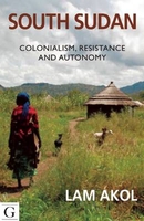
South Sudan: Colonialism, Resistance And Autonomy

Sudan has long been a country of two halves, united by colonial boundaries. Juba, the capital of South Sudan, was the center of huge celebration when the country was declared a new and independent state in 2012. This landmark book recounts how the South history unrolled over the past 100 years - essential reading for anyone needing to understand Sudan today.
RIP - This product is no longer available on our network. It was last seen on 25.09.2019

This page now acts as a permanent archive for this product. Add more information using the comments box below to ensure it can still be found by future generations.

Use our search facility to see if it is available from an alternative contributor.
  • Availability: Out Of Stock
  • Supplier: Stanfords
  • SKU: 9781908531322
Availability: In Stock
£14.95

Product Description

Sudan has long been a country of two halves, united by colonial boundaries. Juba, the capital of South Sudan, was the center of huge celebration when the country was declared a new & independent state in 2012. This landmark book recounts how the South history unrolled over the past 100 years
- essential reading for anyone needing to understand Sudan today.

Reviews/Comments

Add New

Intelligent Comparison

Oooops!
We couldn't find anything!
Perhaps this product's unique.... Or perhaps we are still looking for comparisons!
Click to bump this page and we'll hurry up.

Price History

Vouchers

No voucher codes found.
Do you know a voucher code for this product or supplier? Add it to Insights for others to use.

Facebook

Jargon Buster

History - Anything that happens in the past. An acedemic subject.

Supplier Information

Stanfords
Stanfords was established in 1853 and opened their iconic Covent Garden flagship store in 1901. They have become the top retailer of maps, travel books and accessories in the UK and arguably offer the largest selection of maps and travel books worldwide. Famous names such as Captain Robert Falcon Scott, Ranulph Fiennes and Michael Palin have purchased from Stanfords. They now have a shop in Bristol and both stores together with other venues operate a calendar of events including talks, book signings and exhibitions. As a specialist map retailer, the map selection is comprehensive and includes road maps, street maps and walking maps from worldwide destinations, as well as a selection of world atlases and wall maps. Books include travel guides and travel literature. Stanfords also stock globes, from miniatures made of blue marble to magnificent floor-standing globes. The website features a selection of interesting articles on travel topics.
Page Updated: 2023-11-12 20:15:36

Community Generated Product Tags

Oh No! The productWIKI community hasn't generated any tags for this product yet!
Menu