
 United Kingdom
 France
 Germany
 Netherlands
 Sweden
 USA
USA
 Italy
Italy
 Spain
Spain
More From Contributor


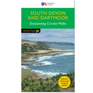
South Devon & Dartmoor
This collection of walks complements Pathfinder South Devon & Dartmoor, an area acclaimed as the last great wilderness in Britain. The haunting beauty of the central moorland studded with old tin mines and one of Britain`s highest concentrations of historic remains is explored on several routes through the national park, including those passing Vixen Tor, one of the tallest and most distinctive granite tors on Dartmoor, Princetown and Buckfastleigh Moor. However, there are also explorations of the hills, river valleys and picturesque villages of the surrounding countryside the South Hams and south-east Devon, and especially the spectacular coastline. Contents 1. Cockington Valley 2. Bench Tor 3. Gara Rock and Portlemouth Down 4. Stover Country Park and the River Teign 5. Vixen Tor
and Pew Tor 6. Exe estuary and Exminster Marshes 7. The Yealm Estuary 8. Venn Ottery Common 9. Dart Estuary and Dartmouth Castle 10. Broadhembury 11. Loddiswell and the Avon Valley Woods 12. Ashburton and Whiddon Scrubs 13. Three Reservoirs Walk 14. Brixham and Churston Point 15. Prawle Point and Woodcombe Point 16. Otter Estuary, East Budleigh and Otterton 17.Kingston and the River Erme 18.Bolt Head and Salcombe Estuary 19.Start Point and Hallsands 20. Torcross, Slapton Ley and Stokenham 21. Beer and Branscombe 22. Rippon Tor, Pil Tor and Buckland Beacon 23. Widgery Cross and Great Links Tor 24. Yes Tor and High Willhays 25. Sidmouth, Salcombe Regis and Weston Combe 26. Princetown, Dartmoor Railway and Leather Tor 27. Dittisham, Cornworthy and Tuckenhay 28. Buckfastleigh Moor
and Pew Tor 6. Exe estuary and Exminster Marshes 7. The Yealm Estuary 8. Venn Ottery Common 9. Dart Estuary and Dartmouth Castle 10. Broadhembury 11. Loddiswell and the Avon Valley Woods 12. Ashburton and Whiddon Scrubs 13. Three Reservoirs Walk 14. Brixham and Churston Point 15. Prawle Point and Woodcombe Point 16. Otter Estuary, East Budleigh and Otterton 17.Kingston and the River Erme 18.Bolt Head and Salcombe Estuary 19.Start Point and Hallsands 20. Torcross, Slapton Ley and Stokenham 21. Beer and Branscombe 22. Rippon Tor, Pil Tor and Buckland Beacon 23. Widgery Cross and Great Links Tor 24. Yes Tor and High Willhays 25. Sidmouth, Salcombe Regis and Weston Combe 26. Princetown, Dartmoor Railway and Leather Tor 27. Dittisham, Cornworthy and Tuckenhay 28. Buckfastleigh Moor

Product Description
Reviews/Comments
Add New
Vouchers
No voucher codes found.
Do you know a voucher code for this product or supplier? Add it to Insights for others to use.
Do you know a voucher code for this product or supplier? Add it to Insights for others to use.
 Denmark