
 United Kingdom
 France
 Germany
 Netherlands
 Sweden
 USA
USA
 Italy
Italy
 Spain
Spain
More From Contributor


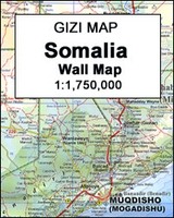
Somalia Wall Map
Somalia Wall Map at 1:1, 750, 000 from Gizi Map, size 86 x 94cm (34” x 38” approx.), covering the whole territory within the internationally recognized borders of the country and showing its current (autumn 2012) de facto division into Somaliland and Somalia, as well as the self-proclaimed autonomous states within Somalia: Puntland, Galmudug and Jubaland, plus the disputed region claimed by Somaliland but under Puntland administration. Also marked are internal administrative borders within these states/regions and names of the provinces. All place names are given in the Latin alphabet with, where appropriate, alternative names or transliterations.Topography is vividly presented in the cartographic style characteristic of Gizi Map: altitude colouring, graphics for swamps, salt
flats and deserts, plenty of names of mountain ranges and other geographical features, spot heights, water wells, etc.Road network includes country tracks and gives distances on main routes. Local airports and seaports are marked and a range of symbols indicate various places of interest, including locations with hotel accommodation, historical sites, etc. Coverage includes Djibouti and the eastern part of Ethiopia. Latitude and longitude lines are drawn at 1° intervals. The index is next to the map, with separate lists for Somaliland, Somalia and Djibouti. Multilingual map legend includes English and Arabic.Also provided are two plans of Mogadishu: a general map of the town showing names of districts and main traffic routes, plus a more detailed street plan of the central area.
Both are annotated with various facilities and places of interest.PLEASE NOTE: this title is also available in a folded format.

Product Description
Reviews/Comments
Add New
Vouchers
No voucher codes found.
Do you know a voucher code for this product or supplier? Add it to Insights for others to use.
Do you know a voucher code for this product or supplier? Add it to Insights for others to use.
 Denmark