More From Contributor

£12.95
Steve Ashton’s Cicerone guide to Scrambling in Snowdonia is an extensive companion on any keen scrambler’s trip to mid-Wales. Each of the routes described are in the northern half of Snowdonia National Park where some of the most rugged mountains are found; opportunities in the southern half being scarcer. Ashton divides the area into four main regions, from north to south these being the Carneddau, the Glyders, the Snowdon group & Eifionydd. Most detail is given to the Glyders, where some of the best scrambles are found; the large majority being focussed on Tryfan, Glyder Fach & Glyder Fawr. The choice of routes is personally selected by Ashton & features over sixty routes, the range of difficulty varying between scrambly walks to the boundaries of proper rock climbing. Therefore the guide is suitable for those with an average level of fitness & a head for heights in addition to those with advanced mountaineering skills & experience. Labelled black & white photographs helps indicate the different stage of each routes alongside the detailed route descriptions. ...
Archived Product
£12.99
The Snowdonia Slate Trail is a new waymarked trail that runs for 83 miles through North Wales. It leads from the coast at Bangor into the heart of Snowdonia to make a circuit ending at Bethesda. The trail joins up villages with a choice of welcoming accommodation. The walking is varied, ranging from easy valleys to mountain passes, from wild moorland to river gorges. Highlights include the National Slate Museum of Wales, stunning views of Snowdon & nearby mountains, & abandoned slate villages high in the hills. The trail also passes the Penrhyn quarry with its impressive galleries of slate crossed by the longest, fastest zip-wire in Europe. This guidebook is in rucksack-friendly format & printed on rainproof paper. Lavishly illustrated with 95 colour photos, it contains large-scale mapping & all you need to plan & enjoy your holiday:14 pages with clear mapping of the route at 1: 40, 000practical information about public transport & travelsection with inside knowledge on how best to climb Snowdondetailed route descriptions including where to find refreshments & accommodationbackground on the slate industry heritage, the ` Great Little Trains of Wales` & wildlife. ...
Archived Product
£15.95
Waterproof mountain map of Snowdonia South from Harvey at 1:40, 000, with a geological map of the region on the reverse, as well as an extension to the main map covering Aberdovey & advice on navigating the region safely. *MAIN MAP:* Topography is shown through clear altitude shading, spot heights, contours at 15m intervals, & index contours at 75m intervals. A variety of symbols are used to show terrain detail, such as caves/mines, major & climbing crags, shafts, sinkholes, cairns, & large boulders. The map is GPS compatible, with the National Grid overprinted on the cartography. Rights of way shown include tracks, long distance & intermittent paths. Road detail

Includes::
minor, residential & forest roads; railway lines & stops are marked, as are chairlifts & ski tows. Points of interest & facilities such as campsites, information points, & mountain rescue post are prominently highlighted.*GEOLOGICAL MAP:* The reverse shows a geological map of the region from the British Geological Survey, with detailed relief shading & colours used to denote different types of rock. There is additional written geological information, as well as a geological timeline of the region.*ADDITIONAL INFORMATION:* There is also information on mountain incident & first aid, navigating the region safely & tips for using maps & compasses. Useful contact numbers are provided. Additional information text is in English & Welsh. Printed on tough, hard-wearing polyethylene, the map is waterproof, tear-resistant, & comes in a clear plastic wallet.

...
Archived Product
£11.99
Snowdonia, Anglesey & the Llyn Peninsula in the Pathfinder Guides series, produced in association with Ordnance Survey & published by Crimson; comprising a range of walking guides to popular British destinations. Each Pathfinder guide

Includes::
28 varied walks ranging from easy strolls to exhilarating hikes & is accompanied by 1:25, 000 Ordnance Survey mapping with marked, colour-coded routes. Introductory sections profile the county or region covered, with recommendations on the best time to visit & a brief explanation of GPS. An

...
Archived Product
£10.95
Snowdonia: Snowdon / Yr Wyddfa at 1:25, 000 on a waterproof & tear-resistant, GPS compatible map from Harvey Map Services in their Superwalker series covering popular hiking areas of Great Britain & Irel&, annotated with additional information for walkers. The maps have contours at 15m intervals, with additional graphics for various types of terrain (crags, large boulders, scattered rocks) & colouring for different kinds of land use or vegetation (pastures, bogs, forests or woodl&, etc). The maps show local hiking paths, indicating, where appropriate, long-distance routes & boundaries of national parks or other protected areas. Scottish titles also indicate Munro, Corbett & Graham hills. Some maps in addition highlight local cycle routes.A range of symbols mark various facilities for walkers including youth or independent hostels, campsites & caravan sites, information points, etc. Each map has a 1-km with British or Irish national grid. ...
Archived Product
£10.95
Snowdonia: the Glyderau & the Carneddau at 1:25, 000 on a waterproof & tear-resistant, GPS compatible map from Harvey Map Services in their Superwalker series covering popular hiking areas of Great Britain & Irel&, annotated with additional information for walkers. The maps have contours at 15m intervals, with additional graphics for various types of terrain (crags, large boulders, scattered rocks) & colouring for different kinds of land use or vegetation (pastures, bogs, forests or woodl&, etc). The maps show local hiking paths, indicating, where appropriate, long-distance routes & boundaries of national parks or other protected areas. Scottish titles also indicate Munro, Corbett & Graham hills. Some maps in addition highlight local cycle routes.A range of symbols mark various facilities for walkers including youth or independent hostels, campsites & caravan sites, information points, etc. Each map has a 1-km with British or Irish national grid. ...
Archived Product
£7.99
Previously titled Pistols for Two, this collection

Includes::
three of Heyer`s earliest short stories, published

...
Archived Product
£12.99
A. D. Miller's Snowdrops is an intensely riveting psychological drama that unfolds over the course of one Moscow winter, as a young Englishman's moral compass is spun by the seductive opportunities revealed to him by a new Russia: a land of hedonism & desperation, corruption & kindness, magical dachas & debauched nightclubs; a place where secrets
- & corpses
- come to light only when the deep snows start to thaw
- Snowdrops is a chilling story of love & moral freefall: of the corruption, by a corrupt society, of a corruptible young man. It is taut, intense & has a momentum as irresistible to the reader as the moral danger that first enchants, then threatens to overwhelm, its narrator.


...
Archived Product
£8.99
Snowdrops. That`s what the Russians call them
- the bodies that float up into the light in the thaw. Drunks, most of them, &
...
Archived Product

Snowdonia: 2016

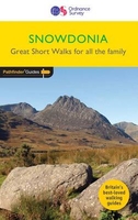
Short Walks Snowdonia covering parts of Abergynolwyn, Conwy and Snowdon. This selection offers interest and regional variety in Snowdonia, providing the best short walks in the area. Covering walks through the whole of the Snowdonia, both popular and little know scenic routes including the Eastern Moors and the River Lathkill. - See walk locations by Looking Inside Inside: -20 circular walks up to 5 miles - Clear, large scale Ordnance Survey route maps - GPS reference for all Snowdonia waypoints - Where to park, good pubs and places of interest en route - All routes have been fully researched and written by expert outdoor writers - Beautiful photography of scenes from the walks Ideal for families, or for those who prefer shorter distances, Short Walks guides contain 20 walks graded
by distance, duration and difficulty. Each route includes points of interest as well as fun observation questions for children.
RIP - This product is no longer available on our network. It was last seen on 25.09.2019

This page now acts as a permanent archive for this product. Add more information using the comments box below to ensure it can still be found by future generations.

Use our search facility to see if it is available from an alternative contributor.
  • External links may include paid for promotion
  • Availability: Out Of Stock
  • Supplier: Stanfords
  • SKU: 9780319090244
Availability: In Stock
£7.99

Product Description

Short Walks Snowdonia covering parts of Abergynolwyn, Conwy & Snowdon. This selection offers interest & regional variety in Snowdonia, providing the best short walks in the area. Covering walks through the whole of the Snowdonia, both popular & little know scenic routes including the Eastern Moors & the River Lathkill.
- See walk locations by Looking Inside Inside: -20 circular walks up to 5 miles
- Clear, large scale Ordnance Survey route maps
- GPS reference for all Snowdonia waypoints
- Where to park, good pubs & places of interest en route
- All routes have been fully researched & written by expert outdoor writers
- Beautiful photography of scenes from the walks Ideal for families, or for those who prefer shorter distances, Short Walks guides contain 20 walks graded by distance, duration & difficulty. Each route

Includes::
points of interest as well as fun observation questions for children.

Reviews/Comments

Add New

Intelligent Comparison

Oooops!
We couldn't find anything!
Perhaps this product's unique.... Or perhaps we are still looking for comparisons!
Click to bump this page and we'll hurry up.

Price History

Vouchers

No voucher codes found.
Do you know a voucher code for this product or supplier? Add it to Insights for others to use.

Facebook

Jargon Buster

GPS - Global Positioning System - Global position using satellites
Fun - Something that provides amusement or enterainment
Large - something that takes up more space than normal.
Popular - Something that is admired and liked by many people.
Regional - An adjective to describe a set geographic area.
Children - A young life form within the early stages of physical development,
Reference - To prove evidence with a back up source.
Ideal - Something that satisfies a perfect criteria.

Supplier Information

Stanfords
Stanfords was established in 1853 and opened their iconic Covent Garden flagship store in 1901. They have become the top retailer of maps, travel books and accessories in the UK and arguably offer the largest selection of maps and travel books worldwide. Famous names such as Captain Robert Falcon Scott, Ranulph Fiennes and Michael Palin have purchased from Stanfords. They now have a shop in Bristol and both stores together with other venues operate a calendar of events including talks, book signings and exhibitions. As a specialist map retailer, the map selection is comprehensive and includes road maps, street maps and walking maps from worldwide destinations, as well as a selection of world atlases and wall maps. Books include travel guides and travel literature. Stanfords also stock globes, from miniatures made of blue marble to magnificent floor-standing globes. The website features a selection of interesting articles on travel topics.
Page Updated: 2023-11-12 20:15:36

Community Generated Product Tags

Oh No! The productWIKI community hasn't generated any tags for this product yet!
Menu