More From Contributor
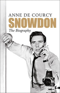
£27.99
To complement the first volume (CCE151) which covered the eastern side of the Mont Blanc massif, this second volume covers the western area, from the Envers des Aigilles to the Tre-la-Tete basin. As with volume one the guide is in full colour throughout &

Includes::
descriptions of 663 routes, shown on 232 colour photographs & also

Includes::
11 maps. It should be noted that while these guides are not definitive the vast majority of routes are covered. This title has not yet been released. You may pre-order now & we will deliver it to you when it arrives. Expected: 1st January 2017


...
Archived Product
£9.95
Snow-finder France is a pocket-sized guide proving skiers & snowboarders with an overview of where to find the best snow in a range of resorts in the French Alps. The guide is arranged by resort, with each entry featuring an introduction to the slopes, information boxes on the high & low points of the resort, information on getting there (with a basic overview map), a double-page spread on the main routes down the mountain, colour photographs, tourist information details & a description of the area by a local expert. There are also very brief indexes with basic advice for planning a skiing trip, accommodation & how to work during a ski season in the Alps. ...
Archived Product
£16.99
How many snowflakes are needed to make a snowman? Where is the snowiest place on Earth? When will the last snowflake fall? Snow has a lot in common with religion. It comes from heaven. It changes everything. It creates an alternative reality & brings on irrational behaviour in humans. But unlike most religions, snow has never had a bible, until now. Giles Whittell, a passionate snow enthusiast, takes the reader on a quest through centuries & continents to reveal the wonders of snow. Along the way he uncovers the mysteries of snow crystal morphology, why avalanches happen, how snow saved a British prime minister`s life, & the terrifying truth about the opening ceremony of the 1960 winter Olympics. ` Snow` is the next best thing to a white Christmas, an anthropology & travelogue for everyone from ski addicts to the millions of people who have never even seen it. ...
Archived Product
£8.99
I could hardly believe my eyes. A cold mantle of white was rapidly transforming our sunny paradise into a bizarre winterscape of citrus Christmas trees, cotton wool palms & snowball oranges. When the Kerr family leave Scotland to grow oranges in a secluded valley on the island of Mallorca they are surprised to be greeted by the same freezing weather they have left behind. Then they realise that their new orange farm is a bit of a lemon... Laughter, finds Peter Kerr, is the best medicine when faced with a local dish of rats & the live-chicken-down-a-chimney technique of household maintenance. But their Mallorcan neighbours help them adapt to their new life. ” Snowball Oranges” is hilarious & revealing, full of life & colour, set against the breathtaking beauty of the Mediterranean. ...
Archived Product
£9.99
I could hardly believe my eyes. A cold mantle of white was rapidly transforming our sunny paradise into a bizarre winterscape of citrus Christmas trees, cotton wool palms & snowball oranges. When the Kerr family leave Scotland to grow oranges in a secluded valley on the island of Mallorca they are surprised to be greeted by the same freezing weather they have left behind. Then they realise that their new orange farm is a bit of a lemon... Laughter, finds Peter Kerr, is the best medicine when faced with a local dish of rats & the live-chicken-down-a-chimney technique of household maintenance. But their Mallorcan neighbours help them adapt to their new life. Snowball Oranges is hilarious & revealing, full of life & colour, set against the breathtaking beauty of the Mediterranean. ...
Archived Product
£14.99
Snowdon & the Conwy Valley area of northern Wales on a detailed topographic & GPS compatible map OL17, waterproof version, from the Ordnance Survey’s 1:25, 000 Explorer series. Coverage extends from the peak of Mynydd Graig Goch & Betws-y-Coed northwards & along the coast from Caernarfon to beyond Conwy, Llandudno & Colwyn Bay. Highlights include a section of the Snowdonia National Park, the peak of Snowdon & the Snowdon Mountain Railway, the Pass of Llanberis, the Menai Bridge, etc.MOBILE DOWNLOADS: this title & all the other OS Explorer maps include a code for downloading after purchase the digital version onto your smartphone or tablet for viewing on the OS smartphone app.OS EXPLORER SERIES: to see the list of all the titles in the OS Explorer series, both paper & waterproof versions, please click on the series link. The Explorer series, Ordnance Survey’s most detailed maps recommended for anyone enjoying outdoor activities, provides topographic coverage of Great Britain at 1:25, 000 on GPS compatible maps with hiking trails, cycling routes & extensive tourist information. Each printed map is available either on paper or as a waterproof & tear-resistant OS Active Map, as indicated in its title. Britain’s National Parks & other areas of particular tourist interest are presented on often double-sided OL (Outdoor Leisure) maps, whilst most standard format Explorers cover an area of 30 x 20km (approx. 19 x 12 miles). All three versions (paper, waterproof & digital) are the same & provide plenty of recreational & tourist information, indicating the traditional public right of way paths (except in Scotland where different laws apply), including bridleways & byways. National Trails & other long-distance paths are marked, as well as permissive footpaths or bridleways & on-road or traffic-free cycle routes with, where appropriate, their National/ Regional Cycle Network numbers. Boundaries of access land are clearly marked. A wide range of symbols provides additional tourist information, highlighting camping & caravanning sites, information offices & visitors’ centres, parking & picnicking places, country pubs, sport & recreational facilities including cycle hire locations & mountain biking trails, historic buildings & museums, etc. Exceptionally clear presentation of the landscape is provided by contours at 5m or in the uplands at 10m intervals, with additional spot heights plus colouring and/or graphics for different types of woodlands, orchards, heath, marshl&, scree or boulders, & other topographic features. For GPS users the maps have British National Grid lines at 1km intervals, with latitude & longitude given by margin ticks at 1`. Clearly laid out map legend

Includes::
French & German translations for the tourist information symbols.

...
Archived Product
£8.99
Snowdon & the Conwy Valley area of northern Wales on a detailed topographic & GPS compatible map OL17, paper version, from the Ordnance Survey’s 1:25, 000 Explorer series. Coverage extends from the peak of Mynydd Graig Goch & Betws-y-Coed northwards & along the coast from Caernarfon to beyond Conwy, Llandudno & Colwyn Bay. Highlights include a section of the Snowdonia National Park, the peak of Snowdon & the Snowdon Mountain Railway, the Pass of Llanberis, the Menai Bridge, etc.MOBILE DOWNLOADS: this title & all the other OS Explorer maps include a code for downloading after purchase the digital version onto your smartphone or tablet for viewing on the OS smartphone app.OS EXPLORER SERIES: to see the list of all the titles in the OS Explorer series, both paper & waterproof versions, please click on the series link. The Explorer series, Ordnance Survey’s most detailed maps recommended for anyone enjoying outdoor activities, provides topographic coverage of Great Britain at 1:25, 000 on GPS compatible maps with hiking trails, cycling routes & extensive tourist information. Each printed map is available either on paper or as a waterproof & tear-resistant OS Active Map, as indicated in its title. Britain’s National Parks & other areas of particular tourist interest are presented on often double-sided OL (Outdoor Leisure) maps, whilst most standard format Explorers cover an area of 30 x 20km (approx. 19 x 12 miles). All three versions (paper, waterproof & digital) are the same & provide plenty of recreational & tourist information, indicating the traditional public right of way paths (except in Scotland where different laws apply), including bridleways & byways. National Trails & other long-distance paths are marked, as well as permissive footpaths or bridleways & on-road or traffic-free cycle routes with, where appropriate, their National/ Regional Cycle Network numbers. Boundaries of access land are clearly marked. A wide range of symbols provides additional tourist information, highlighting camping & caravanning sites, information offices & visitors’ centres, parking & picnicking places, country pubs, sport & recreational facilities including cycle hire locations & mountain biking trails, historic buildings & museums, etc. Exceptionally clear presentation of the landscape is provided by contours at 5m or in the uplands at 10m intervals, with additional spot heights plus colouring and/or graphics for different types of woodlands, orchards, heath, marshl&, scree or boulders, & other topographic features. For GPS users the maps have British National Grid lines at 1km intervals, with latitude & longitude given by margin ticks at 1`. Clearly laid out map legend

Includes::
French & German translations for the tourist information symbols.

...
Archived Product
£7.99
Snowdon & the Conwy Valley at 1:25, 000 in a series of Walker’s Maps published by the AA with the cartography from the Ordnance Survey’s Explorer series. The map is double-sided & coverage

Includes::
parts of the New Forest National Park, Bangor, Caernarfon, Llanberis, Llanwnda, Rhyd-Ddu, Batws-y-Coed, Capel Curig, Tal-y-Bont, Llanfairfechan, Conwy. Llandudno, Colwyn Bay, etc. Maps in the AA Walker’s series are identical to the OS Explorer maps & provide plenty of recreational & tourist information, indicating in England & Wales the traditional public rights of way paths, including bridleways & byways restricted or open to motorized traffic. Also shown are other routes with public access, including permissive footpaths & bridleways. For Scotl&, where different access rights apply, the maps provide an additional note explaining the regulations. Special marking indicates National Trails & Recreational Routes & for cyclists the maps show traffic-free routes & the National Cycle Network. A wide range of symbols highlights locations of special tourist interest: camping & caravanning sites, youth hostels, information offices & visitors’ centres, parking & picnicking places, historic buildings (indicating where appropriate National Trust, English Heritage, Historic Scotland or Cadw), sites for various recreational pursuits, country pubs, public toilets, etc. The maps provide detailed presentation of the topography with contours at 5 or 10m intervals, numerous spot heights & colouring and/or graphics for different types of vegetation. Additional colouring shows access l&, including areas managed by the National Trust, Forestry Commission & Woodland Trust. All the standard information expected of high quality survey mapping at this scale is included: finely graded road network, railway lines with stations, cuttings or embankments, individual isolated buildings, etc. For GPS users the British National Grid is drawn at 1km intervals.

...
Archived Product
£14.99
Waterproof & tear-resistant OS Active version of map No. 115 from the Ordnance Survey’s Landranger series at 1:50, 000, with contoured & GPS compatible topographic mapping plus tourist information.MOBILE DOWNLOADS: As well as the physical edition of the map, each Landranger title now

Includes::
a code for downloading after purchase its digital version onto your smartphone or tablet for viewing on the OS smartphone app.OS LANDRANGER SERIES: to see the list of all the titles in the OS Landranger series, both paper & waterproof versions, please click on the series link. Maps in the Landranger series provide plenty of recreational & tourist information, indicating the traditional public right of way paths (except in Scotland where different laws apply), including bridleways & byways restricted or open to motorized traffic. National Trails & selected other long-distance paths are marked, as well as on-road & traffic-free cycle routes with their National/ Regional Cycle Network numbers. National Trust/ National Trust for Scotland & Forestry Commission land is clearly marked, indicating open or restricted access. A range of symbols highlights camping & caravanning sites, youth hostels, tourist information offices & visitors’ centres, parking & picnicking places, World Heritage sites, sport & recreational facilities, etc. The maps provide detailed presentation of topography with contours at 10m intervals, numerous spot heights & additional colouring and/or graphics for different types of woodlands, orchards or parkl&, rock features including scree & cliffs, water features inland & along the sea shore with marshl&, dunes, s&, mud, shingle & the high water mark. All the standard information expected of survey mapping at this scale is included: finely graded road network, railway lines with stations, cuttings, embankments, etc; individual isolated buildings; archaeological & historical sites, etc. For GPS users the British National Grid is shown at 1km intervals, with latitude & longitude given by margin ticks at 1` & cross hairs on the map at 5`. Each map covers an area of 40 x 40km, (approx. 25 x 25 miles).

...
Archived Product
£8.99
Paper version of map No. 115 from the Ordnance Survey’s Landranger series at 1:50, 000, with contoured & GPS compatible topographic mapping plus tourist information.MOBILE DOWNLOADS: As well as the physical edition of the map, each Landranger title now

Includes::
a code for downloading after purchase its digital version onto your smartphone or tablet for viewing on the OS smartphone app.OS LANDRANGER SERIES: to see the list of all the titles in the OS Landranger series, both paper & waterproof versions, please click on the series link. Maps in the Landranger series provide plenty of recreational & tourist information, indicating the traditional public right of way paths (except in Scotland where different laws apply), including bridleways & byways restricted or open to motorized traffic. National Trails & selected other long-distance paths are marked, as well as on-road & traffic-free cycle routes with their National/ Regional Cycle Network numbers. National Trust/ National Trust for Scotland & Forestry Commission land is clearly marked, indicating open or restricted access. A range of symbols highlights camping & caravanning sites, youth hostels, tourist information offices & visitors’ centres, parking & picnicking places, World Heritage sites, sport & recreational facilities, etc. The maps provide detailed presentation of topography with contours at 10m intervals, numerous spot heights & additional colouring and/or graphics for different types of woodlands, orchards or parkl&, rock features including scree & cliffs, water features inland & along the sea shore with marshl&, dunes, s&, mud, shingle & the high water mark. All the standard information expected of survey mapping at this scale is included: finely graded road network, railway lines with stations, cuttings, embankments, etc; individual isolated buildings; archaeological & historical sites, etc. For GPS users the British National Grid is shown at 1km intervals, with latitude & longitude given by margin ticks at 1` & cross hairs on the map at 5`. Each map covers an area of 40 x 40km, (approx. 25 x 25 miles).

...
Archived Product

Snowdon

Anthony Armstrong-Jones was born to a Welsh father and English-Jewish mother. Creative and inventive, he attended Eton and then Cambridge. The engagement of this motorbike-riding freelance photographer in 1960 to Princess Margaret was a bombshell. Friends privately predicted disaster. And so it proved. But meanwhile in the 1960s, mixing with actors, artists and pop stars, they were the epitome of stylish and unstuffy arts-loving Royals - and one of the iconic glamorous couples of that era. Tony continued to work and both began to have affairs. They divorced in 1978. Snowdon married again but this marriage collapsed after the birth of a secret love-child and the suicide of his mistress of twenty years. His low boredom threshold and waspish cruelty are balanced by his fabled charm and
genuine concern for the disabled and underpriviledged. One of the great British photographers, at 76 he now suffers from a recurrence of childhood polio. But by any standards he has had an extraordinary life.
RIP - This product is no longer available on our network. It was last seen on 25.09.2019

This page now acts as a permanent archive for this product. Add more information using the comments box below to ensure it can still be found by future generations.

Use our search facility to see if it is available from an alternative contributor.
  • Availability: Out Of Stock
  • Supplier: Stanfords
  • SKU: 9780753825877
Availability: In Stock
£9.99

Product Description

Anthony Armstrong-Jones was born to a Welsh father & English-Jewish mother. Creative & inventive, he attended Eton & then Cambridge. The engagement of this motorbike-riding freelance photographer in 1960 to Princess Margaret was a bombshell. Friends privately predicted disaster. & so it proved. But meanwhile in the 1960s, mixing with actors, artists & pop stars, they were the epitome of stylish & unstuffy arts-loving Royals
- & one of the iconic glamorous couples of that era. Tony continued to work & both began to have affairs. They divorced in 1978. Snowdon married again but this marriage collapsed after the birth of a secret love-child & the suicide of his mistress of twenty years. His low boredom threshold & waspish cruelty are balanced by his fabled charm & genuine concern for the disabled & underpriviledged. One of the great British photographers, at 76 he now suffers from a recurrence of childhood polio. But by any standards he has had an extraordinary life.

Reviews/Comments

Add New

Intelligent Comparison

Oooops!
We couldn't find anything!
Perhaps this product's unique.... Or perhaps we are still looking for comparisons!
Click to bump this page and we'll hurry up.

Price History

Vouchers

No voucher codes found.
Do you know a voucher code for this product or supplier? Add it to Insights for others to use.

Facebook

Jargon Buster

Stylish - A desirable design or layout
Friends - A close associate or a popular US based sitcom about a group of friends
Love - Someone who shows deep affection for someone else.
Genuine - A product that is "real", from the manufactuer, not a fake.

Supplier Information

Stanfords
Stanfords was established in 1853 and opened their iconic Covent Garden flagship store in 1901. They have become the top retailer of maps, travel books and accessories in the UK and arguably offer the largest selection of maps and travel books worldwide. Famous names such as Captain Robert Falcon Scott, Ranulph Fiennes and Michael Palin have purchased from Stanfords. They now have a shop in Bristol and both stores together with other venues operate a calendar of events including talks, book signings and exhibitions. As a specialist map retailer, the map selection is comprehensive and includes road maps, street maps and walking maps from worldwide destinations, as well as a selection of world atlases and wall maps. Books include travel guides and travel literature. Stanfords also stock globes, from miniatures made of blue marble to magnificent floor-standing globes. The website features a selection of interesting articles on travel topics.
Page Updated: 2023-11-12 20:15:36

Community Generated Product Tags

Oh No! The productWIKI community hasn't generated any tags for this product yet!
Menu