More From Contributor

£14.99
With one of the most moving & tragic diaspora stories of World War II, Slovenia 1945 follows the fate of a strongly Catholic & non-Communist community in Slovenia caught up in the maelstrom of war & politics in the Balkans & the problems of post-war settlement. Thousands of soldiers returned to face death & exile at the hands of their wartime enemies. Thousands more civilians narrowly escaped the same fate. Yet the story of exile is also one of triumph as the refugees built new lives around the world. In this book, the authors call on more than 50 years of research &, for the first time, the survivors tell their story of wartime cruelty, refugee camps & emigration, building new lives through courage, self-help & strong cultural identity. ...
Archived Product
£9.99
Slovenia at 1:205, 000 on a doubled-sided, indexed map from the National Geographic Society. Cartographic information provided by Reise Know-How has been adjusted to follow the house style of the NGS Adventure series with greater emphasis on the country’s topography. Altitude colouring in broader bands has been replaced here by contours at 200m intervals enhanced by relief shading. Road network

Includes::
selected local tracks & gives driving distances on main & some connecting roads. Railway lines are included & local airports are marked. Internal administrative boundaries are shown with names of the provinces. Symbols highlight various places of interest, including selected campsites, viewpoints, caves & natural sites, etc, & boundaries of national parks & other protected areas are marked. The map has a grid with latitude & longitude at intervals of 10’ & an index of localities. Overall, the smaller scale of the NGS map & the presentation the road network make the original Reise Know-How edition clearer for touring the country.PLEASE NOTE: to ensure regular supplies & faster delivery to our customers we keep as regular stock the Reise Know-How edition whilst the NGS version can be ordered on request.

...
Archived Product
£9.95
Croatia & Slovenia at 1:800, 000 from Mair Dumont, also covering the whole of Serbia, Bosnia-Herzegovina, Montenegro, Macedonia & Albania, with special features to aid route plannding & street plans of central Zagreb, Dubrovnik, Split, Rijeka, Sarajevo & Belgrade. Maps in the Mair Dumont ...
Archived Product
£12.99
Slovenia & the Slovenes, a Small State in the New Europe, is a well documented introduction to the history & culture of modern Slovenia. One of the few books dedicated to Slovenia, this is an account of this country’s history & its people. Expect in depth information on political, economic & cultural life. This is not just an investigation of Slovenian’s struggle for independence from Yugoslavia but also a study of its development into the vibrant Slovenia of today’s & its prospects for the future.A compelling read for anyone interested in understanding the history & culture of this country before, during & after Yugoslavia. ...
Archived Product
£15.99
Slovenia Eyewitness travel guide from Dorling Kindersley is a lavishly illustrated book concerned with providing the visitor with detailed background information to sightseeing in the country & a broad cultural introduction. Popular historical buildings & museums are often described with cutaway diagrams allowing you to view ...
Archived Product
£10.99
Slovenia at 1:200, 000 from Freytag & Berndt, on a detailed, indexed road map presenting the whole country on one side of the map as an alternative to the publisher’s double-sided version at 1:150, 000. Coverage

Includes::
the south-eastern corner of Austria with the Carinthian lakes around Klagenfurt & Villach. Topography is shown by relief shading, with spot heights & plenty of names of peaks, valleys, etc. National parks & protected areas are marked. Road network

Includes::
minor roads & cart tracks, & indicates driving distances on most local routes, roads closed to motorized traffic or not recommended for caravans, seasonal closures on mountain roads, steep gradients, toll sections, motorway services, etc. Special tourist routes & scenic roads are highlighted. Railway lines are shown with stations & local airports are marked. Picturesque towns & villages are highlighted. Symbols mark other places of interest & facilities, including campsites & youth hostels, golf course, museums, etc. The map also highlights the course of long-distance hiking routes across the northern part of the country. Latitude & longitude lines are drawn at intervals of 10’. The index is in a separate booklet attached to the map cover.* Map legend include English.* The same cartography, enlarged to 1:150, 000 for clearer presentation, is also used in F&B’s “ Top 10 Tips” double-side map of Slovenia, with additional tourist information & street plans.


...
Archived Product
£10.99
Slovenia at 1:150, 000 on a double-sided, indexed road map in Freytag & Berndt’s “ Top 10 Tips” series, with brief descriptions of the country’s ten best sights, plus street plans of Ljubljana ad Maribor. Coverage

Includes::
the Italian side of the Julian Alps, extending west to Udine, & the north-western corner of Croatia with Zagreb. Topography is shown by relief shading, with spot heights & plenty of names of peaks, valleys, etc. National parks & protected areas are marked. Road network

Includes::
minor roads & cart tracks, & indicates driving distances on most local routes, roads closed to motorized traffic or not recommended for caravans, seasonal closures on mountain roads, steep gradients, toll sections, motorway services, etc. Special tourist routes & scenic roads are highlighted. Railway lines are shown with stations & local airports are marked. Picturesque towns & villages are highlighted. The country’s 10 top sights are prominently marked, with brief descriptions provided in a booklet attached to the map cover. Symbols mark other places of interest & facilities, including campsites & youth hostels, golf course, museums, etc. The map also highlights the course of long-distance hiking routes across the northern part of the country. Latitude & longitude lines are drawn at intervals of 10’. The booklet attached to the map cover also

Includes::
an index listing all localities with their postcodes, plus street central Ljubljana & Maribor.* Map legend & the descriptions of the sights include English.** The same cartography is also used in F&B’s map at 1:200, 000 showing the whole of Slovenia on one side, with slightly different coverage of the neighbouring regions & no additional tourist information on the top sights or street plans.


...
Archived Product
£14.99
This is the first edition of the Komshe travel guidebook to Slovenia, written & published by travel specialists from south eastern Europe. The guide is divided into sections covering 5 regions of Slovenia (including the capital, Ljubljana), with more than 100 tourist destinations. The book

Includes::
regional & town maps, accommodation listings as well as other practical information. With this guide you can discover Slovenia`s history, culture, landscape & cuisine while gaining an understanding of customs, manners & more! There are other basic, useful facts: visas, health & security, transport, banks & currency, active holidays, shopping advice, sports activities & other important tips for travellers. There are more than 500 colour photos illustrating what to expect before embarking on your travels. Of special note are places rarely visited by most tourists
- ancient castles, monasteries, national parks & relics of the Roman, Austro-Hungarian & Yugoslav legacy. The guide

Includes::
insider recommendations for Slovenia`s festivals, arts, concerts & nightlife.


...
Archived Product
£7.99
Slovenia in the Pocket Guide series from Insight provides detailed commentary on a collection of itinerary based trips in a handy pocket format. The guide has an historical & cultural introduction, profiling the growth of the country. There is also a large selection of localised & pedestrian friendly tour itineraries designed to take in the major sites. Further sections detail leisure activities including shopping, eating out, nightlife, festivals & local events with accompanying addresses & contact details where relevant. There is also practical guidance on transport, local services, language & accommodation, a large selection of colour photographs & a pull-out pocket map. ...
Archived Product
£24.99
Slovenia at 1:75, 000 presented in an A4, paperback road atlas from the Ljubljana-based Kartografija with very detailed GPS-compatible mapping at 1:75, 000, including vivid presentation of the topography, extensive tourist overprint, plus 11 indexed street plans, a distance table, etc. Coverage

Includes::
the border areas of Italy around Trieste & Gorizia. The atlas shows names of numerous villages not marked on road maps of the whole country at less detailed scales. Landscape is very effectively presented by relief shading with plenty of spot heights & names of topographic features such as mountain ranges, valleys, peaks, etc, plus boundaries of national parks. Road network is graded into 10 types, from motorways to forest roads, indicating unsurfaced roads, services & petrol stations, restrictions for caravans, & driving distances on main & secondary routes. A range of symbols indicate various facilities & places of interest including campsites, motels, tourist farms & other types of accommodation, inns & wine cellars or shops, spas, etc. The maps have latitude & longitude lines at 5’ intervals. Map legend

Includes::
English. The atlas also

Includes::
indexed one or two-page street plans of Ljubljana, Celje, Koper, Kranj, Maribor, Murska Sobota, Nova Gorica, Novo Mesto, Ptuj, Slovenj Gradec & Velenje. Symbols show car parks & petrol stations, hotels, shopping centres, tourist information offices & other facilities.


...
Archived Product

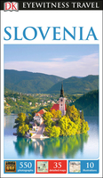
Slovenia Eyewitness Guide

Slovenia Eyewitness travel guide from Dorling Kindersley is a lavishly illustrated book concerned with providing the visitor with detailed background information to sightseeing in the country and a broad cultural introduction. Popular historical buildings and museums are often described with cutaway diagrams allowing you to view “inside” your destination, sites are shown with bird’s eye plans and small, more conventional maps contextualise regions and pinpoint places of interest.A travellers’ needs section details places to stay, eat and shop, as well as looking at entertainment, nightlife and outdoor activities. A survival guide features practical tips for preparation, logistics and health and safety, whilst a mini phrase section at the back of the book helps you with
useful communication phrases.
RIP - This product is no longer available on our network. It was last seen on 25.09.2019

This page now acts as a permanent archive for this product. Add more information using the comments box below to ensure it can still be found by future generations.

Use our search facility to see if it is available from an alternative contributor.
  • External links may include paid for promotion
  • Availability: Out Of Stock
  • Supplier: Stanfords
  • SKU: 9780241275412
Availability: In Stock
£15.99

Product Description

Slovenia Eyewitness travel guide from Dorling Kindersley is a lavishly illustrated book concerned with providing the visitor with detailed background information to sightseeing in the country & a broad cultural introduction. Popular historical buildings & museums are often described with cutaway diagrams allowing you to view “inside” your destination, sites are shown with bird’s eye plans & small, more conventional maps contextualise regions & pinpoint places of interest.A travellers’ needs section details places to stay, eat & shop, as well as looking at entertainment, nightlife & outdoor activities. A survival guide features practical tips for preparation, logistics & health & safety, whilst a mini phrase section at the back of the book helps you with useful communication phrases.

Reviews/Comments

Add New

Intelligent Comparison

Oooops!
We couldn't find anything!
Perhaps this product's unique.... Or perhaps we are still looking for comparisons!
Click to bump this page and we'll hurry up.

Price History

Vouchers

No voucher codes found.
Do you know a voucher code for this product or supplier? Add it to Insights for others to use.

Facebook

Jargon Buster

Eye - An organ which detects light
Entertainment - Something that provides amusement
Safety - prevents damage being caused.
Small - something that takes up less space than normal.
Practical - Weather a task is easy to carry out and realistically succeed.
Popular - Something that is admired and liked by many people.

Supplier Information

Stanfords
Stanfords was established in 1853 and opened their iconic Covent Garden flagship store in 1901. They have become the top retailer of maps, travel books and accessories in the UK and arguably offer the largest selection of maps and travel books worldwide. Famous names such as Captain Robert Falcon Scott, Ranulph Fiennes and Michael Palin have purchased from Stanfords. They now have a shop in Bristol and both stores together with other venues operate a calendar of events including talks, book signings and exhibitions. As a specialist map retailer, the map selection is comprehensive and includes road maps, street maps and walking maps from worldwide destinations, as well as a selection of world atlases and wall maps. Books include travel guides and travel literature. Stanfords also stock globes, from miniatures made of blue marble to magnificent floor-standing globes. The website features a selection of interesting articles on travel topics.
Page Updated: 2023-11-12 20:15:36

Community Generated Product Tags

Oh No! The productWIKI community hasn't generated any tags for this product yet!
Menu