More From Contributor

£9.99
Map No. 815, Skyline Boulevard Parks & Preserves along the ridge of the Santa Cruz Mountains in California in an extensive series of GPS compatible, contoured hiking maps of USA’s national & state parks or forests & other popular recreational areas. Cartography based on the national topographic survey, with additional tourist information. The maps, with most titles now printed on light, waterproof & tear-resistant plastic paper, highlight walking trails along with campsites & other accommodation, picnic sites, areas for various recreational pursuits such as horse riding or skiing, drinking water sources, & many other facilities of interest to the outdoor enthusiast. Cartography is based on information from the USGS (United States Geological Survey
- the country’s national survey organization), revised by the National Geographic Maps in cooperation with the National Park Service, USDA Forest Service, etc. Topography is excellently presented by contours (interval varies according to scale), enhanced by relief shading & colouring/graphics for wood cover, glaciers, etc. All heights are given in feet. The maps have a UTM grid plus latitude & longitude margin ticks & GPS waypoints for selected important locations. Each map is double-sided to give either maximum coverage of the chosen area or additional enlargements of its important sections. Accompanying notes provide useful information on relevant regulations, safety precautions, contact addresses, etc.IMPORTANT
- PLEASE NOTE: the series is very extensive, ranging in scale from 1:400, 000 for the vast national parks of Alaska to 1:25, 000 for local map in several states. We recommend, therefore, viewing the series by state rather than the whole list.

...
Archived Product
£9.99
Skyline London: A Guide to the Finest Views from the Capital`s High Points from Aurum Press lists 48 places, both buildings & hills, which offer the finest views of the city, from the latest addition to this selected group of vantage points, The Shard, to the old favourites like Parliament Hill or Richmond Park. Each location has a description of the views plus information on how to get there &, where appropriate, opening hours & contact details for more information. Some entries, including the very popular London Eye, are also accompanied by maps naming many of the buildings on view. The guide is illustrated with numerous colour photos. ...
Archived Product
£18.99
Skylines features fifty of the most iconic, vibrant & often magnificent places from across the globe. This is your key to exploring the world through the architectural triumphs that make our cities famous. Beautiful & atmospheric illustrations accompany an introduction to these famous vistas, summing up their spirit, history & location. Short histories of each place reveal threads that illuminate often well-trodden streets. This compilation is defined by the one-of-a-kind buildings including fortresses, palaces, sacred sites, monuments, skyscrapers & cultural hotspots that makes each one unique. See how well you really know these cities as they are depicted through the silhouettes of their most noteworthy buildings. ...
Archived Product
£12.99
Big city life unites the planet. Every habitable continent has metropolitan hot spots that are a hive of activity, a hub of culture
-
...
Archived Product
£199.00
The highly portable SKYMAX-102 EQ2 is ideal for the observation of double-stars, & the surface detail of the Moon & bright planets. Despite its small

Dimensions, it packs a powerful punch. Its high-resolution, long focal length optical system is multi-coated to maximise contrast & image sharpness.

...
Archived Product
£299.00
The highly portable SKYMAX-127 EQ3-2 is ideal for the observation of double-stars, & the surface detail of the Moon & bright planets. Despite its compact

Dimensions, it packs a powerful punch. Its high-resolution, long focal length optical system is multi-coated to maximise contrast & image sharpness.

...
Archived Product
£7.50
Road Edition maps are produced in co-operation with the Hellenic Army Geographical Service, the national survey organisation. The maps have contours with colour altitude tints. All the place names are shown in both Greek & Roman script. Road classification distinguishes between unsurfaced roads of good & poor quality. Tourist information

Includes::
scenic routes, petrol stations, archaeological sites, campsites, beaches, etc. Brief descriptions, in Greek & English, illustrate some of the interesting aspects of each isl&. Map legend

Includes::
English. On the reverse, there are lists of various types of accommodation from hotels to private rooms. Please note: deliveries from Road Editions are not very reliable. For titles currently not in stock it may be advisable to choose a map from another publisher.


...
Archived Product
£5.99
Skyros 1:48, 000 with recommendations for six hiking trails on a detailed, contoured & GPS compatible map from Anavasi, printed on light, waterproof & tear-resistant synthetic paper. Topography is very clearly presented by contours at 20m intervals, with relief shading & altitude colouring. Road network indicates unsurfaced roads & sections in poor condition & shows driving distances. The marking for footpaths shows well defined or faint paths. Symbols highlight various places of interest & facilities, including beaches, campsites, museums, etc. The map has a 1km UTM grid plus latitude & longitude crosshairs at 1’. Map legend

Includes::
English. On the reverse is a smaller, simplified map of the island highlighting six recommended hiking routes, accompanied by brief descriptions. Also provided are general notes about the isl&, plus a list of useful contact details. The text is bilingual Greek/ English. To see which other Greek islands are covered by maps from Anavasi, please click on the series link.

...
Archived Product
£9.99
Skyros at 1:35, 000 on a contoured, GPS compatible hiking map published by Terrain Cartography group together with Skai Maps, & printed on light, waterproof & tear-resistant Polyart plastic paper, with extensive tourist information. Topography is very well presented by contours, enhanced by spot heights, subtle relief shading & additional altitude colouring. Contour interval, unless indicated below to the contrary, is 20m. National parks & other protected areas are marked. All place names are shown in both Greek & Latin alphabet. The maps have a UTM grid, plus latitude & longitude margin ticks. Hiking trails are graded between main routes & narrow trails. A wide range of symbols indicate various places of interest & recreational facilities, with main sights clearly highlighted. Most titles distinguish between sandy & pebble beaches; some also indicate beaches with natural shade and/or the type of sea bed. Road network is very clearly graded according to width & the type of surface, distinguishing between good & rough dirt roads. Distances are marked on most small local roads, as well as locations of petrol stations and/or tyre repair workshops. Scenic routes are highlighted. Each map also shows which ports are served by ferry services. Many titles include a street plan of the island’s main town, with colouring clearly showing various tourist facilities. The reverse side of each title is covered by general information about the isl&, illustrated with colour photos. Many titles also include brief descriptions of recommended hiking trails.* Map legend & all the text include English.** In this title:* descriptions of two selected hiking trails. ...
Archived Product
£20.00
Chicago`s beautiful Reliance Building, sixteen storeys tall, was designed in 1890 by John Root & completed in 1895 by Charles B. Atwood. In its construction
- metal frame, large areas of plate glass, fire-proof brick & terracotta cladding
- it pioneers all the key elements of twentieth-century high-rise architecture, & many of the tenets of Modernism. Cruickshank reflects on the extraordinary architectural, artistic & engineering world of the 1890s & its great figures such as Daniel H. Burnham, Louis Sullivan & William Le Baron Jenney. He looks forward to the Reliance building`s immediate progeny, such as the 1902 Flatiron Building in New York & to the hubristic high-rise architecture of the twenty-first century. This is also the story of Gilded Age Chicago, which was burned to the ground in 1871. The city
- corrupt, violent & fabulously wealthy
- was ready to try anything, even revolutionary forms of architecture.


...
Archived Product

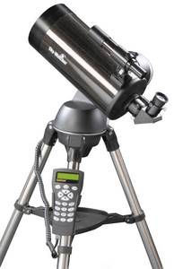
Skymax-127 SynScan AZ Goto Telescope

The exciting Sky-Watcher SynScan™ AZ Computerised GoTo telescopes will allow you to easily find and track night sky treasures, such as Planets, Nebulae, Star Clusters, Galaxies and much more. The SynScan™ AZ hand control allows you point your telescope automatically at a specific object, or even tour the night sky at the touch of a button!! The user-friendly menu system allows automatic slewing to over 42, 900+ night sky objects. Even an inexperienced astronomer can master its variety of features in a few observing sessions. The Skymax-127 is a larger version of the Skymax-102 providing a massive 55% more light-gathering power, and packing an even more powerful punch than its smaller cousin for medium-to-high-power work.
RIP - This product is no longer available on our network. It was last seen on 25.09.2019

This page now acts as a permanent archive for this product. Add more information using the comments box below to ensure it can still be found by future generations.

Use our search facility to see if it is available from an alternative contributor.
  • Availability: Out Of Stock
  • Supplier: Stanfords
  • SKU: 6930096610187
Availability: In Stock
£479.00

Product Description

The exciting Sky-Watcher Syn Scan™ AZ Computerised Go To telescopes will allow you to easily find & track night sky treasures, such as Planets, Nebulae, Star Clusters, Galaxies & much more. The Syn Scan™ AZ hand control allows you point your telescope automatically at a specific object, or even tour the night sky at the touch of a button!! The user-friendly menu system allows automatic slewing to over 42, 900+ night sky objects. Even an inexperienced astronomer can master its variety of features in a few observing sessions. The Skymax-127 is a larger version of the Skymax-102 providing a massive 55% more light-gathering power, & packing an even more powerful punch than its smaller cousin for medium-to-high-power work.

Reviews/Comments

Add New

Intelligent Comparison

Oooops!
We couldn't find anything!
Perhaps this product's unique.... Or perhaps we are still looking for comparisons!
Click to bump this page and we'll hurry up.

Price History

Vouchers

No voucher codes found.
Do you know a voucher code for this product or supplier? Add it to Insights for others to use.

Facebook

Jargon Buster

Hand - A part of the body at the end of the arm
Hand - A pointer which indicates time on a clock face
Button - A round or square object used for fastening clothing or other items
star - A giant ball of plasma held together by gravity.
button - A small fastener used on clothing to secure two pieces of fabric together.

Supplier Information

Stanfords
Stanfords was established in 1853 and opened their iconic Covent Garden flagship store in 1901. They have become the top retailer of maps, travel books and accessories in the UK and arguably offer the largest selection of maps and travel books worldwide. Famous names such as Captain Robert Falcon Scott, Ranulph Fiennes and Michael Palin have purchased from Stanfords. They now have a shop in Bristol and both stores together with other venues operate a calendar of events including talks, book signings and exhibitions. As a specialist map retailer, the map selection is comprehensive and includes road maps, street maps and walking maps from worldwide destinations, as well as a selection of world atlases and wall maps. Books include travel guides and travel literature. Stanfords also stock globes, from miniatures made of blue marble to magnificent floor-standing globes. The website features a selection of interesting articles on travel topics.
Page Updated: 2023-11-12 20:15:36

Community Generated Product Tags

Oh No! The productWIKI community hasn't generated any tags for this product yet!
Menu