More From Contributor

£19.99
The Western Hemisphere in the third quarter of the 19th century presented on a reproduction of a beautiful wall map (size 88 x 106cm / 35 x 42 approx) with cartography which will appeal instantly to all who love browsing through old atlases. The original map was drawn by Stanford ...
Archived Product
£4.50
This beautifully printed wrapping paper displays a reproduction of John Speed's New & Accurate Map of the World of 1627. In its first edition this was one of the earliest world maps to show the famous misconception of California as an isl&. It is also renowned for its lively decoration, including symbolic figures of the four elements & portraits of the explorers Drake, Cavendish, Van Noort & Magellan. ...
Archived Product
£8.50
Produced on high quality paper, these cards display a reproduction of John Speed's New & Accurate Map of the World of 1627. In its first edition this was one of the earliest world maps to show the famous misconception of California as an isl&. It is also renowned for its lively decoration, including symbolic figures of the four elements & portraits of the explorers Drake, Cavendish, Van Noort & Magellan. Each pack contains 10 cards with 10 envelopes. ...
Archived Product
£12.00
Exclusive to Stanfords. Our fabulous all-purpose cotton bag in Teal or Red is perfect for books, general shopping & everyday use. Features strong webbed handles & premium 10oz cotton making this bag tough & durable. Features internal side pocket. Dimensions: 38 (wide) x 36cm; 60cm Handle 100% Cotton. Cold hand wash separately. Do not iron / tumble dry / dry clean. ...
Archived Product
£8.99
This quality re-usable mug is just perfect for your hot drinks on the go. For every mug sold, Stanfords will donate 50p to our chosen charity partner, The Real Africa Trust (Explorers Against Extinction). Double-wall insulated. The body of this mug is dishwasher & microwave safe. BPA free. Capacity 35cl. ...
Archived Product
£12.99
This exclusive Stanfords water bottle has 500ml capacity, is hand wash only & for cold drinks only. The design is printed in white on a red matt frosted finish. The screw cap comes with a karabiner. For every bottle sold, Stanfords will donate £1 to our chosen charity partner, Explorers Against Extinction (The Real Africa Trust). ...
Archived Product
£69.99
Reproduction of a very interesting map of Africa published by our founder Edward Stanford in 1879 & showing the continent in the relatively early stages of its colonization. The information marked on the map forms a fascinating mixture of names of towns, countries or colonial possessions, geographical regions or features such as deserts, & of many African tribes. Although the map has no physical colouring, it instantly conveys much information about the continent’s geography through the distribution of the already explored regions with established administrative entities. The bulk of the coastline is already in colour & various political units are shown in the more accessible Sahel belt, from the Atlantic along the Niger & around Lake Chad to Darfur & northern Ethiopia. However, the Sahara & the great expanse of the continent around the Congo (called here Livingstone River) & further south & east are yet to be colonized. Although, in many places, particular in East Africa, various geographical features are already marked on the map. Latitude & longitude lines are drawn at 10° intervals. Of all the continents, Africa has undergone most changes from the mid 19th century to the present day & this map provides an early step towards understanding its history. This is the A1 canvas version. ...
Archived Product
£19.99
Reproduction of a very interesting map of Africa published by our founder Edward Stanford in 1879 & showing the continent in the relatively early stages of its colonization. The information marked on the map forms a fascinating mixture of names of towns, countries or colonial possessions, geographical regions or features such as deserts, & of many African tribes. Although the map has no physical colouring, it instantly conveys much information about the continent’s geography through the distribution of the already explored regions with established administrative entities. The bulk of the coastline is already in colour & various political units are shown in the more accessible Sahel belt, from the Atlantic along the Niger & around Lake Chad to Darfur & northern Ethiopia. However, the Sahara & the great expanse of the continent around the Congo (called here Livingstone River) & further south & east are yet to be colonized. Although, in many places, particular in East Africa, various geographical features are already marked on the map. Latitude & longitude lines are drawn at 10° intervals. Of all the continents, Africa has undergone most changes from the mid 19th century to the present day & this map provides an early step towards understanding its history. This is the A1 paper version. ...
Archived Product
£49.99
Reproduction of a very interesting map of Africa published by our founder Edward Stanford in 1879 & showing the continent in the relatively early stages of its colonization. The information marked on the map forms a fascinating mixture of names of towns, countries or colonial possessions, geographical regions or features such as deserts, & of many African tribes. Although the map has no physical colouring, it instantly conveys much information about the continent’s geography through the distribution of the already explored regions with established administrative entities. The bulk of the coastline is already in colour & various political units are shown in the more accessible Sahel belt, from the Atlantic along the Niger & around Lake Chad to Darfur & northern Ethiopia. However, the Sahara & the great expanse of the continent around the Congo (called here Livingstone River) & further south & east are yet to be colonized. Although, in many places, particular in East Africa, various geographical features are already marked on the map. Latitude & longitude lines are drawn at 10° intervals. Of all the continents, Africa has undergone most changes from the mid 19th century to the present day & this map provides an early step towards understanding its history. This is the A2 canvas version. ...
Archived Product

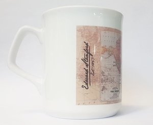
Stanfords World Map Mug

A wonderful addition to the Stanfords products line, this mug features Stanford’s Map of the World 1920.Own a piece of Stanford’s history, ponder about the world back in 1920s and the political changes that it has undergone since, follow the shipping routes testament of a bygone era, or just enjoy your morning coffee or your afternoon tea in such a stylish and unique mug.
RIP - This product is no longer available on our network. It was last seen on 25.09.2019

This page now acts as a permanent archive for this product. Add more information using the comments box below to ensure it can still be found by future generations.

Use our search facility to see if it is available from an alternative contributor.
  • External links may include paid for promotion
  • Availability: Out Of Stock
  • Supplier: Stanfords
  • SKU: 9786000506469
Availability: In Stock
£2.99

Product Description

A wonderful addition to the Stanfords products line, this mug features Stanford’s Map of the World 1920. Own a piece of Stanford’s history, ponder about the world back in 1920s & the political changes that it has undergone since, follow the shipping routes testament of a bygone era, or just enjoy your morning coffee or your afternoon tea in such a stylish & unique mug.

Reviews/Comments

Add New

Intelligent Comparison

Oooops!
We couldn't find anything!
Perhaps this product's unique.... Or perhaps we are still looking for comparisons!
Click to bump this page and we'll hurry up.

Price History

Vouchers

No voucher codes found.
Do you know a voucher code for this product or supplier? Add it to Insights for others to use.

Facebook

Jargon Buster

mug - A sturdy type of cup typically used for hot beverages.
Coffee - A popular brewed drink using roasted coffee beans
Stylish - A desirable design or layout
History - Anything that happens in the past. An acedemic subject.
World - A physical grouping, commonly used to describe earth and everything associated with ti
Tea - A hot beverage made from the leaves of a tea plant
Wonderful - Another word for describing something that is extremely good, marvellous.

Supplier Information

Stanfords
Stanfords was established in 1853 and opened their iconic Covent Garden flagship store in 1901. They have become the top retailer of maps, travel books and accessories in the UK and arguably offer the largest selection of maps and travel books worldwide. Famous names such as Captain Robert Falcon Scott, Ranulph Fiennes and Michael Palin have purchased from Stanfords. They now have a shop in Bristol and both stores together with other venues operate a calendar of events including talks, book signings and exhibitions. As a specialist map retailer, the map selection is comprehensive and includes road maps, street maps and walking maps from worldwide destinations, as well as a selection of world atlases and wall maps. Books include travel guides and travel literature. Stanfords also stock globes, from miniatures made of blue marble to magnificent floor-standing globes. The website features a selection of interesting articles on travel topics.
Page Updated: 2023-11-12 20:15:36

Community Generated Product Tags

Oh No! The productWIKI community hasn't generated any tags for this product yet!
Menu