
 United Kingdom
 France
 Germany
 Netherlands
 Sweden
 USA
USA
 Italy
Italy
 Spain
Spain
More From Contributor


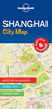
Shanghai Flexi Map
Shanghai on a laminated, tear-resistant Insight Flexi Map with an indexed street plan of the city’s central districts, a plan of a wider area of the Shanghai conurbation including the Pudong New Area, a diagram of the metro network, a regional road map including Nanjing and Hangzhou, plus extensive tourist information.On one side is a street plan of Shanghai’s central districts, highlighting numerous facilities and places of interest, including selected hotels. Metro and railway stations and lines are clearly marked. For drivers, the plan indicates main traffic arteries. All place names are in both Chinese and Latin alphabets. On the reverse is a plan of a wider part of the city including the Pudong New Area, plus a regional road map highlighting main places of interest; both
maps have place names in Latin alphabet only. Both the main plan and the two additional maps are indexed, including lists of places of interest. A special feature of the Insight Flexi series are panels with additional tourist information:- 37 main sights, neatly grouped into sections covering Major Attractions, Other Attractions, Shopping, and Further Afield, are given brief descriptions and are prominently highlighted on the relevant maps.- Further panels provide information on Getting Around and Facts for Visitors, including tourist information offices, opening times, money, tipping, telecommunications and monthly climate charts.To see other titles in this series please click on the series link.
maps have place names in Latin alphabet only. Both the main plan and the two additional maps are indexed, including lists of places of interest. A special feature of the Insight Flexi series are panels with additional tourist information:- 37 main sights, neatly grouped into sections covering Major Attractions, Other Attractions, Shopping, and Further Afield, are given brief descriptions and are prominently highlighted on the relevant maps.- Further panels provide information on Getting Around and Facts for Visitors, including tourist information offices, opening times, money, tipping, telecommunications and monthly climate charts.To see other titles in this series please click on the series link.
Product Description
Reviews/Comments
Add New
Vouchers
No voucher codes found.
Do you know a voucher code for this product or supplier? Add it to Insights for others to use.
Do you know a voucher code for this product or supplier? Add it to Insights for others to use.
 Denmark