More From Contributor
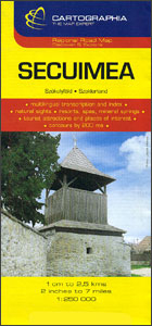
£24.50
Sector 7, the Boroughs of Hounslow, Richmond & Kingston in the division of Greater London into nine Knowledge Yellow Badge sectors, presented on a paper wall map at 1:21, 477 (3” to 1 mile) from Geographers’ A-Z Map Company. Current 1st edition of this title was prepared in 2011 & is also available in an encapsulated version. Maps in the A-Z’s Knowledge Yellow Badge series for London have the publishers’ well known & trusted cartography used in their coverage of London by other maps & atlases, highlighting A & B roads & indicating dual carriageways, junction names, & one way or restricted entry streets. Boundaries of the congestion & low emission zones are clearly marked, as well as locations of safety cameras with speed limits. Selected A & B roads are annotated with house numbers for easier identification of addresses. Railway, Underground & Dockland Light Railway stations are named & the Croydon Tramlink is shown with stops. Colouring and/or symbols indicate public building, services & facilities, including shopping centres or market streets, selected car parks, etc. Each map also shows local authority & postcode boundaries. The index is in a separate A4-size folder &

Includes::
names of road junctions, housing estates, hospitals & hospices, selected places of interest, etc, where appropriate colour-coded for easier reference. For the encapsulated version of this title & other maps in this series please click on the series link.

...
Archived Product
£44.99
Sector 8, the Boroughs of Hillingdon & Ealing in the division of Greater London into nine Knowledge Yellow Badge sectors, presented on an encapsulated wall map at 1:21, 477 (3” to 1 mile) from Geographers’ A-Z Map Company. Current 1st edition of this title was prepared in 2011 & is also available in a paper version. Maps in the A-Z’s Knowledge Yellow Badge series for London have the publishers’ well known & trusted cartography used in their coverage of London by other maps & atlases, highlighting A & B roads & indicating dual carriageways, junction names, & one way or restricted entry streets. Boundaries of the congestion & low emission zones are clearly marked, as well as locations of safety cameras with speed limits. Selected A & B roads are annotated with house numbers for easier identification of addresses. Railway, Underground & Dockland Light Railway stations are named & the Croydon Tramlink is shown with stops. Colouring and/or symbols indicate public building, services & facilities, including shopping centres or market streets, selected car parks, etc. Each map also shows local authority & postcode boundaries. The index is in a separate A4-size folder &

Includes::
names of road junctions, housing estates, hospitals & hospices, selected places of interest, etc, where appropriate colour-coded for easier reference. For the paper version of this title & other maps in this series please click on the series link.LAMINATED & ENCAPSULATED WALL MAPS:- LAMINATED wall maps have a thin layer of plastic usually applied to the printed side only. They can be written on with suitable marker pens without any damage to the map but, unless laminated on both sides, they are not damp-proof.- ENCAPSULATED wall maps are sealed between two sheets of plastic. They are more rigid & heavier than laminated maps of the same size. They are damp-proof & do not crinkle in humid conditions. Encapsulation gives the map a shiny surface, similar to being displayed behind glass.- PLEASE NOTE: many publishers & retailers often use these two terms interchangeably. Our map titles & descriptions follow the definitions provided above.

...
Archived Product
£24.50
Sector 8, the Boroughs of Hillingdon & Ealing in the division of Greater London into nine Knowledge Yellow Badge sectors, presented on a paper wall map at 1:21, 477 (3” to 1 mile) from Geographers’ A-Z Map Company. Current 1st edition of this title was prepared in 2011 & is also available in an encapsulated version. Maps in the A-Z’s Knowledge Yellow Badge series for London have the publishers’ well known & trusted cartography used in their coverage of London by other maps & atlases, highlighting A & B roads & indicating dual carriageways, junction names, & one way or restricted entry streets. Boundaries of the congestion & low emission zones are clearly marked, as well as locations of safety cameras with speed limits. Selected A & B roads are annotated with house numbers for easier identification of addresses. Railway, Underground & Dockland Light Railway stations are named & the Croydon Tramlink is shown with stops. Colouring and/or symbols indicate public building, services & facilities, including shopping centres or market streets, selected car parks, etc. Each map also shows local authority & postcode boundaries. The index is in a separate A4-size folder &

Includes::
names of road junctions, housing estates, hospitals & hospices, selected places of interest, etc, where appropriate colour-coded for easier reference. For the encapsulated version of this title & other maps in this series please click on the series link.

...
Archived Product
£24.50
Sector 9, the Boroughs of Harrow, Barnet & Brent in the division of Greater London into nine Knowledge Yellow Badge sectors, presented on a paper wall map at 1:19, 000 (3.3” to 1 mile) from Geographers’ A-Z Map Company. Current 1st edition of this title was prepared in 2011 & is also available in an encapsulated version. Maps in the A-Z’s Knowledge Yellow Badge series for London have the publishers’ well known & trusted cartography used in their coverage of London by other maps & atlases, highlighting A & B roads & indicating dual carriageways, junction names, & one way or restricted entry streets. Boundaries of the congestion & low emission zones are clearly marked, as well as locations of safety cameras with speed limits. Selected A & B roads are annotated with house numbers for easier identification of addresses. Railway, Underground & Dockland Light Railway stations are named & the Croydon Tramlink is shown with stops. Colouring and/or symbols indicate public building, services & facilities, including shopping centres or market streets, selected car parks, etc. Each map also shows local authority & postcode boundaries. The index is in a separate A4-size folder &

Includes::
names of road junctions, housing estates, hospitals & hospices, selected places of interest, etc, where appropriate colour-coded for easier reference. For the encapsulated version of this title & other maps in this series please click on the series link.

...
Archived Product
£44.99
Sector 9, the Boroughs of Harrow, Barnet & Brent in the division of Greater London into nine Knowledge Yellow Badge sectors, presented on an encapsulated wall map at 1:19, 000 (3.3” to 1 mile) from Geographers’ A-Z Map Company. Current 1st edition of this title was prepared in 2011 & is also available in a paper version. Maps in the A-Z’s Knowledge Yellow Badge series for London have the publishers’ well known & trusted cartography used in their coverage of London by other maps & atlases, highlighting A & B roads & indicating dual carriageways, junction names, & one way or restricted entry streets. Boundaries of the congestion & low emission zones are clearly marked, as well as locations of safety cameras with speed limits. Selected A & B roads are annotated with house numbers for easier identification of addresses. Railway, Underground & Dockland Light Railway stations are named & the Croydon Tramlink is shown with stops. Colouring and/or symbols indicate public building, services & facilities, including shopping centres or market streets, selected car parks, etc. Each map also shows local authority & postcode boundaries. The index is in a separate A4-size folder &

Includes::
names of road junctions, housing estates, hospitals & hospices, selected places of interest, etc, where appropriate colour-coded for easier reference. For the paper version of this title & other maps in this series please click on the series link.LAMINATED & ENCAPSULATED WALL MAPS:- LAMINATED wall maps have a thin layer of plastic usually applied to the printed side only. They can be written on with suitable marker pens without any damage to the map but, unless laminated on both sides, they are not damp-proof.- ENCAPSULATED wall maps are sealed between two sheets of plastic. They are more rigid & heavier than laminated maps of the same size. They are damp-proof & do not crinkle in humid conditions. Encapsulation gives the map a shiny surface, similar to being displayed behind glass.- PLEASE NOTE: many publishers & retailers often use these two terms interchangeably. Our map titles & descriptions follow the definitions provided above.

...
Archived Product
£29.00
Rigid PVC sign with printed insert that can be oriented to show three security levels through a window in the front face. 150mm x 300mm. Stanfords is an official distributor of Maritime Progress safety signs. We are able to source a full range of their products manufactured in Engl&. Signs are available in many sizes & materials. For example, photoluminescent & regular vinyl or PVC, available as self-adhesive stickers or rigid signs. Maritime Progress has a great selection of IMO safety signs, direction & hazard signs, fire equipment signs, posters & hazard tapes. If you would like more information, a paper catalogue or cannot find a desired product, please email us at maritime@stanfords.co.uk. We will be glad to help! ...
Archived Product
£5.00
Security seal manufactured from a special plastic which tears when attempts to peel it off are made. Ideal for securing bonds etc. Stanfords is an official distributor of Maritime Progress safety signs. We are able to source a full range of their products manufactured in Engl&. Signs are available in many sizes & materials. For example, photoluminescent & regular vinyl or PVC, available as self-adhesive stickers or rigid signs. Maritime Progress has a great selection of IMO safety signs, direction & hazard signs, fire equipment signs, posters & hazard tapes. If you would like more information, a paper catalogue or cannot find a desired product, please email us at maritime@stanfords.co.uk. We will be glad to help! ...
Archived Product
£6.95
Topographic coverage of mainland Spain at 1:50, 000 in the MTN50 (Mapa Topográfico Nacional) series from the Centro Nacional de Información Geografica, the country’s civilian survey organization. The maps have contours at 20m intervals, enhanced by relief shading, plus colouring and/or graphics to show different types of terrain, vegetation or land use. Boundaries of national parks & other protected areas are marked. In addition to all the usual information featured on topographic mapping at this scale, detailed presentation of the road & rail networks, rural tracks & paths, etc, the maps also show campsites & mountain refuges. On more recent editions some GRs, the official long-distance hiking routes, are also marked (although not as clearly as on hiking maps from other publishers). Each map covers 29.5x 18.5 km (with adjustments in the border or coastal areas). The maps have a 1-km UTM grid, plus margin ticks for latitude & longitude at 1` intervals. Map legend is in Spanish only.HOW TO CHOOSE THE RIGHT 50K MAP: all the titles in CNIG’s 200K Provincial Road Maps series at 1:200, 000 are overprinted with the grid for the 1:50, 000 maps & can be used to see the area covered by each 50K title. TO SEE THE LIST OF TITLES IN THIS SERIES PLEASE CLICK ON THE SERIES LINK.PLEASE NOTE
- MAP TITLES: the grids shown on our website serve both the civilian & the military 1:50, 000 topographic series. Although the areas covered by maps in both series are identical (apart from some border or coastal sheets), occasionally map titles differ – only one title is shown on the grid, usually the military one. In Galicia, the Basque country & in the Catalan speaking areas the tendency now is to use local place names rather than the often better known Castilian ones. Where possible, both versions are included in our titles. Map titles listed on our website are based on information received by us at the time of publication, but sometimes maps arrive showing a completely different title! As long as the map number is as ordered, the correct map has been supplied.
...
Archived Product
£17.99
One of the titles in a series of maps from the Israeli Survey, in Hebrew
- with some Roman alphabet equivalents, providing coverage
...
Archived Product
£3.50
Sedgley North East & Deepfields in 1901 in a fascinating series of reproductions of old Ordnance Survey plans in the Alan Godfrey Editions, ideal for anyone interested in the history of their neighbourhood or family. The map covers the north-east of Sedgley, extending eastward to Hurst Hill, Upper Ettingshall, & northward to Cinder Hill, Woodcross & Deepfields. Features include Mount Pleasant, tramways, Beacon Court, St Mary`s church, Priorfield Colliery, Breen Rhydding Colliery (disused), Ettingshall Colliery, Ward`s Meadow Colliery, short stretch of LNWR Stour Valley Line, Birmingham Canal, Beaconhill Quarry, Spring Vale Colliery, old coal shafts, etc. A 1912 directory of Coseley is on the reverse. About the Alan Godfrey Editions of the 25” OS Series: Selected towns in Great Britain & Ireland are covered by maps showing the extent of urban development in the last decades of the 19th & early 20th century. The plans have been taken from the Ordnance Survey mapping & reprinted at about 15 inches to one mile (1:4, 340). On the reverse most maps have historical notes & many also include extracts from contemporary directories. Most maps cover about one mile (1.6kms) north/south, one & a half miles (2.4kms) across; adjoining sheets can be combined to provide wider coverage.FOR MORE INFORMATION & A COMPLETE LIST OF ALL AVAILABLE TITLES PLEASE CLICK ON THE SERIES LINK. ...
Archived Product

Secuimea

Secuimea on an indexed road map at 1:250, 000 from Cartographia, providing coverage of central and eastern parts of Transylvania, from Cluj Napoca and Alba Iulia eastward, with coverage extending south to Sibiu and Brasov. The map has contours at 100m intervals, plus spot heights, names of mountain ranges and colouring for forested areas. Road network includes small local roads and tracks and gives distances on main routes. Railways lines are shown with stations. Symbols show a variety of features e.g. motels, campsites, antiquities, thermal baths, churches and sites of interest. Latitude and longitude lines are at 20` intervals. Map legend includes English. Towns and villages are shown with their old Hungarian, and for larger towns also German names. The index, on the reverse
of the map, is in three parts, listing current Romanian names, plus their old Hungarian and German equivalents.
RIP - This product is no longer available on our network. It was last seen on 25.09.2019

This page now acts as a permanent archive for this product. Add more information using the comments box below to ensure it can still be found by future generations.

Use our search facility to see if it is available from an alternative contributor.
  • External links may include paid for promotion
  • Availability: Out Of Stock
  • Supplier: Stanfords
  • SKU: 9789633524787
Availability: In Stock
£7.50

Product Description

Secuimea on an indexed road map at 1:250, 000 from Cartographia, providing coverage of central & eastern parts of Transylvania, from Cluj Napoca & Alba Iulia eastward, with coverage extending south to Sibiu & Brasov. The map has contours at 100m intervals, plus spot heights, names of mountain ranges & colouring for forested areas. Road network

Includes::
small local roads & tracks & gives distances on main routes. Railways lines are shown with stations. Symbols show a variety of features e.g. motels, campsites, antiquities, thermal baths, churches & sites of interest. Latitude & longitude lines are at 20` intervals. Map legend

Includes::
English. Towns & villages are shown with their old Hungarian, & for larger towns also German names. The index, on the reverse of the map, is in three parts, listing current Romanian names, plus their old Hungarian & German equivalents.

Reviews/Comments

Add New

Intelligent Comparison

Oooops!
We couldn't find anything!
Perhaps this product's unique.... Or perhaps we are still looking for comparisons!
Click to bump this page and we'll hurry up.

Price History

Vouchers

No voucher codes found.
Do you know a voucher code for this product or supplier? Add it to Insights for others to use.

Facebook

Jargon Buster

Railways - A set of tracks that have been laid for the purpose of trains to travel up and down them
Network - A link and communication between things. Often computers or people.
Small - something that takes up less space than normal.
Road - a manmade lane or a path that is used to speed up travel.

Supplier Information

Stanfords
Stanfords was established in 1853 and opened their iconic Covent Garden flagship store in 1901. They have become the top retailer of maps, travel books and accessories in the UK and arguably offer the largest selection of maps and travel books worldwide. Famous names such as Captain Robert Falcon Scott, Ranulph Fiennes and Michael Palin have purchased from Stanfords. They now have a shop in Bristol and both stores together with other venues operate a calendar of events including talks, book signings and exhibitions. As a specialist map retailer, the map selection is comprehensive and includes road maps, street maps and walking maps from worldwide destinations, as well as a selection of world atlases and wall maps. Books include travel guides and travel literature. Stanfords also stock globes, from miniatures made of blue marble to magnificent floor-standing globes. The website features a selection of interesting articles on travel topics.
Page Updated: 2023-11-12 20:15:36

Community Generated Product Tags

Oh No! The productWIKI community hasn't generated any tags for this product yet!
Menu