More From Contributor

£4.99
Scotland in the AA 100 Walks Series, exploring the 100 best walks of between 2 & 10 miles in mainland Scotl&, Skye & Orkney. Information panels introduce each walk in summary detail prior to the more in depth route descriptions, & also include suggestions for nearby car parks & details of relevant Ordnance Survey maps & grid references. Walks are organised by county within the guide & are portrayed on basic route maps which cover rural & urban areas, as well as park & woodl&. Walks are graded according to difficulty & steepness, with easy to follow guidelines. ...
Archived Product
£9.95
Here is the new revised edition of Maclean`s classic work with a new added chapter by Magnus Linklater, who also revised the last edition, that brings the story of Scotland right up to date. Linklater examines how the new Scottish Parliament has fared & discusses significant events such as the controversies over the Holyrood parliament building, devolution & the transfer of taxation rights from Westminster, & the release of the Lockerbie bomber, as well as the fallout from the 2008 global financial crash & the debate about independence & the future of the United Kingdom now that the Scottish National Party is in power. ...
Archived Product
£14.99
From the Ice Age to the recent Scottish Referendum, historian & author Alistair Moffat explores the history of the Scottish nation. As well as focusing on key moments in the nation`s history such as the Battle of Bannockburn & the Jacobite Risings, Moffat also features other episodes in history that are perhaps less well documented. From prehistoric timber halls to inventions & literature, Moffat`s tale explores the drama of battle, change, loss & invention interspersed with the lives of ordinary Scottish folk, the men & women who defined a nation. ...
Archived Product
£17.99
Renowned photographer Douglas Corrance has been taking photographs of Scotland for more than a quarter of a century. This magnificently produced book presents a visual journey around his native l&, covering everything from the rugged peaks of the Highlands to the diverse nature of our cities & towns. As Corrance spent over a decade as photographer to the Scottish Tourist Board it is not surprising to find in these pages a multitude of shots of the archetypal Scotl&, but he skilfully manages to bring something new & fresh to every image, stamping each with his own unique perspective. The result is a collection of remarkable, striking photographs which will give the reader
- whether visitor or native Scot
- a better understanding & clearer view of the myriad facets of Scotland`s beauty.

...
Archived Product
£5.99
Scotland Castles Map is a single-sided sheet showing over 800 castles & fortified houses in the country, accompanied by background & historical information, & an extensive list of sites of interest with contact details. On a base map of Scotland showing motorways, A roads, the rail network, airports & tourist information centres, major castles & fortified houses are displayed using a colour coding system to distinguish between those open to the public, those best viewed from outside & those privately owned. These are all indexed in a table listing names, classification by age & type, accessibility & contact details, & those castles which have notable gardens & grounds. Also
Includes:: Historical, architectural & background information, with map references. Enlarged insets for Aberdeenshire & for east & south-eastern Scotland at 1:600, 000, for greater detail of these important areas. A list of ten of Scotland's finest castles & five castles suitable for children. Black-&-white illustrations of selected castles & houses, with historical & architectural information.
...
Archived Product
£5.99
Scotland Clans & Tartans Map is a single-sided, illustrated sheet showing the historical clans, clan territories & tartans of the country, accompanied by background & historical information, & an extensive list of family names & their associated clans. On a base map of Scotland showing motorways, A roads, the rail network, airports & tourist information centres, key places of interest & family names are overlaid to cover particular areas of influence held by clans in the early 17th century. Also
Includes:: Historical & background information focusing on the clan system & tartans. A list of clan- & tartan-related places of interest, with contact details & map references. Images of tartans & clan badges (with family names) surrounding the map. An extensive list of current Scottish family names & their associated clans. Images of plant badges & a list of their associated clans or families.
...
Archived Product
£30.00
Scotland has had a uniquely important military history over the last five centuries. Conflict with England in the 16th century, Jacobite rebellions in the 18th century, 20th-century defences & the two world wars, as well as the Cold War, all resulted in significant cartographic activity. In this book two map experts explore the extraordinarily rich legacy of Scottish military mapping, including fortification plans, reconnaissance mapping, battle plans, plans of military roads & routeways, tactical maps, plans of mines, enemy maps showing targets, as well as plans showing the construction of defences. In addition to plans, elevations & views, they also discuss unrealised proposals & projected schemes. Most of the maps
- some of them reproduced in book form for the first time
- are visually striking & attractive, & all have been selected for the particular stories they tell about both attacking & defending the country.

...
Archived Product
£20.00
Scotland`s history has been told many times, but never exclusively by its women. This book takes a unique perspective on dramatic national events as well as ordinary life, as experienced by women down the centuries. From the saintly but severe medieval Queen Margaret to today`s first minister Nicola Sturgeon, it encompasses women from all stations of class & fame & notoriety, offering a tantalising view of what happened to them, & how they felt. Drawing on court & kirk records, exchequer rolls & treasurer`s accounts, diaries & memoirs, chap books & newspapers, government reports & eye-witness statements, Scotland: Her Story brings to life the half of history that has for too long been hidden or ignored. Features material by from a hugely diverse range of authors, including: The Maid of Norway * Princess Matilda * St Margaret * Margaret Tudor * Mary, Queen of Scots * Lady Grizel Baillie * Elsie Inglis * Mary Slessor * Catherine Dickens * Jane Carlyle * Madeline Smith * Catherine Carswell * Willa Muir * Nan Shepherd * Muriel Gray * Sue Black * Sally Magnusson * The Queen Mother * Rona Cameron * Elaine C. Smith * Evelyn Glennie * Jessie Kesson * Winnie Ewing * Muriel Spark * Tilda Swinton * Liz Lochhead * Lulu * Janice Galloway * Jackie Kay * Ali Smith * Liz Mc Colgan * Mhairi Black * Judy Murray * Nicola Benedetti * Nicola Sturgeon ...
Archived Product
£8.95
Inland Waterways of Scotland map published by Imray, Laurie, Norie & Wilson & presenting an overview of the whole country locating the navigable waterways, plus more detailed charts & descriptions of individual routes. The map is double-sided:
- on one side is an overview map of Scotland showing all the navigable waterways, descriptions of individual routes, & a more detailed panel showing the Crinan Canal- on the reverse are more detailed maps of the Caledonian Canal, the Union Canal & the Forth & Clyde Canal The panels include, where appropriate, enlargements of various segments of each route & show individual locks, moorings, yacht berths/marinas, canal-side facilities, etc, as well as the surrounding road network. Each panel also

Includes::
notes providing information on maximum channel

Dimensions, lock operating times, bridges, tidal operation, relevant contact addresses, etc.


...
Archived Product
£20.00
Whilst documents & other written material are obvious resources that help shape our view of the past, maps too can say much about a nation`s history. This is the first book to take maps seriously as a form of history, from the earliest representations of Scotland by Ptolemy in the second century AD to the most recent form of Scotland`s mapping & geographical representation in GIS, satellite imagery & SATNAV. Compiled by three experts who have spent their lives working with maps, Scotland: Mapping the Nation offers a fascinating & thought-provoking perspective on Scottish history which is beautifully illustrated with complete facsimiles & details of hundreds of the most significant manuscript & printed maps from the National Library of Scotland & other institutions, including those by Timothy Pont, Joan Blaeu & William Roy, amongst many others. ...
Archived Product

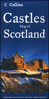
Scotland: Castles Map

Castles Map of Scotland from Collins showing over 700 castles and fortified houses, with an index indicating those open to the public and/or with interesting gardens or grounds, plus enlargements for popular areas, background and historical information, etc.The whole of Scotland is shown at approx. 1:1, 000, 000, with enlargements presenting in Glasgow – Edinburgh – Dundee region and northern Aberdeenshire. All the maps have a base with altitude colouring to indicate the topography, and show the network of main roads and railway lines. Symbols, with numbers cross-referenced to an index of all the sites, indicate which castles are generally opened to the public, normally best viewed from the outside, or are private residences. Also marked are VisitScotland information centres
and points. The index of all the sites marked on the map shows the type and age of each castle, access, notable grounds, plus where available phone numbers and web addresses.The map also includes recommendations for 10 finest castles, five locations particularly great for children, a historical introduction, plus colour photos of selected sites.
RIP - This product is no longer available on our network. It was last seen on 25.09.2019

This page now acts as a permanent archive for this product. Add more information using the comments box below to ensure it can still be found by future generations.

Use our search facility to see if it is available from an alternative contributor.
  • External links may include paid for promotion
  • Availability: Out Of Stock
  • Supplier: Stanfords
  • SKU: 9780007508532
Availability: In Stock
£4.99

Product Description

Castles Map of Scotland from Collins showing over 700 castles & fortified houses, with an index indicating those open to the public and/or with interesting gardens or grounds, plus enlargements for popular areas, background & historical information, etc. The whole of Scotland is shown at approx. 1:1, 000, 000, with enlargements presenting in Glasgow – Edinburgh – Dundee region & northern Aberdeenshire. All the maps have a base with altitude colouring to indicate the topography, & show the network of main roads & railway lines. Symbols, with numbers cross-referenced to an index of all the sites, indicate which castles are generally opened to the public, normally best viewed from the outside, or are private residences. Also marked are Visit Scotland information centres & points. The index of all the sites marked on the map shows the type & age of each castle, access, notable grounds, plus where available phone numbers & web addresses. The map also

Includes::
recommendations for 10 finest castles, five locations particularly great for children, a historical introduction, plus colour photos of selected sites.

Reviews/Comments

Add New

Intelligent Comparison

Oooops!
We couldn't find anything!
Perhaps this product's unique.... Or perhaps we are still looking for comparisons!
Click to bump this page and we'll hurry up.

Price History

Vouchers

No voucher codes found.
Do you know a voucher code for this product or supplier? Add it to Insights for others to use.

Facebook

Jargon Buster

Edinburgh - The capital city of Scotland
phone - Short for telephone. A device that transmits sound allowing point to point communication over long distances
Colour - The categorised spectrum of light visable to humans
Network - A link and communication between things. Often computers or people.
Altitude - Something that can be quite high in relation to sea or ground level.
Popular - Something that is admired and liked by many people.
Children - A young life form within the early stages of physical development,

Supplier Information

Stanfords
Stanfords was established in 1853 and opened their iconic Covent Garden flagship store in 1901. They have become the top retailer of maps, travel books and accessories in the UK and arguably offer the largest selection of maps and travel books worldwide. Famous names such as Captain Robert Falcon Scott, Ranulph Fiennes and Michael Palin have purchased from Stanfords. They now have a shop in Bristol and both stores together with other venues operate a calendar of events including talks, book signings and exhibitions. As a specialist map retailer, the map selection is comprehensive and includes road maps, street maps and walking maps from worldwide destinations, as well as a selection of world atlases and wall maps. Books include travel guides and travel literature. Stanfords also stock globes, from miniatures made of blue marble to magnificent floor-standing globes. The website features a selection of interesting articles on travel topics.
Page Updated: 2023-11-12 20:15:36

Community Generated Product Tags

Oh No! The productWIKI community hasn't generated any tags for this product yet!
Menu