
 United Kingdom
 France
 Germany
 Netherlands
 Sweden
 USA
USA
 Italy
Italy
 Spain
Spain
More From Contributor


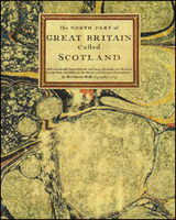
Scotland C.1714 MEDIUM
A cloth-back reproduction (mediuml size) of a map of Scotland drawn in 1714 by Herman Moll and illustrated with 11 panels of lovely, coloured-in views of its main towns including Edinburgh, Glasgow, Sterling, Aberdeen, etc. The map, with an impressive full title of “The Northern Part of Great Britain called Scotland with Considerable Improvements and remarks not Extant in any Map. According to the newest and Exact Observations”, has boundaries of the historical counties outlined in colour. Several places, including the Orkney and Shetland islands presented on an inset, are annotated with interesting notes, e.g. on Lewis “Stornvay Castle was Destroy’d by the English Garrison, kept there by Oliver Cromwell”, next to South Uist “Here is good Fishing for Cod and Ling of
a great size”, etc. On either side of the map are beautiful drawings with views of main towns and/or their principal buildings, including the castles in Edinburgh and Sterling. Each individual cloth-backed map is sold folded in a colourful case covered with a unique design marbled paper – no two cases are identical.PLEASE NOTE: this title is also available in a smaller size, although with place names and annotations difficult to read without a magnifying glass. To see the list of all the titles in this series from the Old Folding Maps please click on the series link.
a great size”, etc. On either side of the map are beautiful drawings with views of main towns and/or their principal buildings, including the castles in Edinburgh and Sterling. Each individual cloth-backed map is sold folded in a colourful case covered with a unique design marbled paper – no two cases are identical.PLEASE NOTE: this title is also available in a smaller size, although with place names and annotations difficult to read without a magnifying glass. To see the list of all the titles in this series from the Old Folding Maps please click on the series link.

Product Description
Reviews/Comments
Add New
Vouchers
No voucher codes found.
Do you know a voucher code for this product or supplier? Add it to Insights for others to use.
Do you know a voucher code for this product or supplier? Add it to Insights for others to use.
 Denmark