More From Contributor
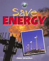
£5.99
Moon Spotlight Savannah & the Georgia Coast is a 145-page compact guide covering historic Savannah & the Golden Isles, including Brunswick & Glynn County, Jekyll Isl&, St. Simon's Isl&, Darien & Mc Intosh County, Cumberland Island & St. Mary's, & the Okefenokee Swamp. Author Jim Morekis offers seasoned advice on what sights are must-sees &

Includes::
maps with sightseeing highlights so that planning your time is easy. This lightweight guide is packed with recommendations on sights, entertainment, shopping, recreation, accommodations, food, & transportation. Helpful maps make navigating these historic areas uncomplicated.
Moon Spotlight guides are affordably-priced, lightweight guides covering a smaller geographic region than Moon Handbooks or Outdoors guidebook series. The travel content in a Spotlight guide is pulled directly from individual chapters of larger Handbooks or Outdoors titles, with no introductory information (such as When to Go or Planning Your Trip), & no indexes. The results are compact guides to popular destinations that provide travelers with what they need to explore a specific locale in depth with fewer pages of very focused information.


...
Archived Product
£9.99
Let Savannah Diaries take you on a safari of discovery through Africa`s most beautiful national parks & big game sanctuaries, in the company of its spectacular wildlife & the remarkable characters
- scientists, conservationists, wardens & safari guides
- who have devoted their lives to protecting its unique heritage for future generations. Written by the preeminent expert on African wildlife, Brian Jackman, Savannah Diaries reveals the staggering size & scale of sub-Saharan Africa in a celebration of the continent`s wild places & their abundance of living creatures.

...
Archived Product
£5.99
Savannah in Georgia with Hilton Head Island in South Carolina on an indexed street plan from ADC, part of the Kappa Map Group. On one side is coverage of the Georgian side, including Garden City, Hutchinson Isl&, Skidaway Island & Thunderbolt; the Hilton Head Island is shown on the reverse at the same scale as the main map. Colouring indicates different types of roads, from controlled access highways & toll roads to local streets. The map shows county & zip code boundaries. Symbols indicate various facilities & places of interest. Extensive index lists places & streets/roads. ...
Archived Product
£9.99
The Savannah Way linking Cairns in Queensland & Broome in Western Australia highlighted on a road map from Hema showing the northern part of Australia with local roads & outback tracks, various facilities including fuel supplies, etc, plus enlargements of popular areas, tables of facilities in national parks, etc. The map is double-sided, showing on one side northern Queensland with the north-western part of Northern Territory; on the reverse coverage starts with a very generous overlap, showing the northern parts of Northern Territory & Western Australia. The course of the Savannah Way, including its suggested variants, is prominently highlighted. Road network indicates sealed & unsealed roads, tracks & rough tracks. Symbols indicate different types of fuel supplies & rest areas, camping & caravanning facilities, local airports, information centres, etc. Also marked are various points of interest. National parks / other protected areas & Aboriginal Lands are prominently highlight 6ed. Topography is shown by names of mountain ranges, deserts, etc, plus graphics for salt pans, swamps, areas subject to inundations, etc. Latitude & longitude lines are drawn at 1º intervals. Enlargements present in greater detail four national parks: Boodjamulla (Lawn Hills) in QLD, Kakadu & Judbarra/ Gregory in NT, plus Purnululu in WA, annotated where useful with GPS coordinates. Also provided are tables of facilities in the national parks across the area covered by the main map, a list of important contact numbers, plus descriptions of various sights. To see other titles in Hema’s series of City to City maps please click on the series link. ...
Archived Product
£7.99
Savannas form one of the largest & most important of the world`s ecological zones. Covering one fifth of the Earth`s land surface, they are home to some of the world`s most iconic animals & form an extremely important global resource for plants & wildlife. However, increasing recognition of their land potential means that they are extremely vulnerable to accelerating pressures on usable l&. This Very Short Introduction considers savannas as landscapes. Discussing their origin, topography, & global distribution, Peter A. Furley explores the dynamic nature of savannas & illustrates how they have shaped human evolution & movements. He goes on to discuss the unrelenting pressures that confront conservation & management & considers the future for savannas. ABOUT THE SERIES: The Very Short Introductions series from Oxford University Press contains hundreds of titles in almost every subject area. These pocket-sized books are the perfect way to get ahead in a new subject quickly. Our expert authors combine facts, analysis, perspective, new ideas, & enthusiasm to make interesting & challenging topics highly readable. ...
Archived Product
£7.50
There are many ways to save the planet, & many a re pretty easy too. Some of these Knowledge Cards describe small but valuable actions that diminish pollution, energy consumption, & landfill mass. Others address topics such as the status of alternative energy sources, tree-free paper, & the beauty of bats. In this deck, 47 such tips & topics are discussed in Q & A format. ...
Archived Product
£26.00
Jamie gets the nation cooking clever, shopping smart & wasting less with his new cookbook, Save with Jamie. This year, I`ve got the message loud & clear that as everyone comes under bigger & bigger financial pressure, they want help to cook tasty, nutritious food on a budget
- so this book was born completely out of public dem&. Save with Jamie draws on knowledge & cooking skills to help you make better choices, showing you how to buy economically & efficiently, get the most out of your ingredients, save time & prevent food waste. & there`s no compromise
- I`m talking big flavours, comfort food that makes you happy, & colourful, optimistic dishes. Our biggest luxury is knowledge, whether times are hard or not, so get kitchen smart & smash the recession. Jamie Oliver started cooking at his parents` pub, The Cricketers, in Clavering, Essex, at the age of eight. His television & publishing career began in 1999 with The Naked Chef series. Since then he has set up Fifteen restaurant in London, changed school dinners in the UK & revolutionized home cooking. His charity, The Jamie Oliver Foundation, seeks to improve people`s lives through food. He writes for publications in the UK & around the world, including his own Jamie Magazine. Jamie lives in London & Essex with his wife Jools & their children.

...
Archived Product
£12.99
Topographic survey of France at 1:25, 000 in IGN`s excellent TOP25 / Série Bleue series. All the maps are GPS compatible, with a 1km UTM grid plus latitude & longitude lines at 5’ intervals. Contours are at 5m intervals except for mountainous areas where the maps have contours at 10m intervals, vividly enhanced by hill shading & graphics for rocky terrain. Colouring with graphics indicates different types of vegetation or land use (deciduous or coniferous forests, moors, orchards, vineyards, etc). PLEASE NOTE: coverage of France at this scale is currently being revised – the format & the presentation of each title are indicated by the letters at the end of its Sheet Reference number (e.g. 0416ET, 3531ETR, 1923SB, etc.)MAPS WITH FULL TOURIST OVERPRINT & AN ENGLISH MAP LEGEND: all TOP25 maps & the SB editions of Série Bleue have an overprint highlighting waymarked walking trails including long-distance GR routes &, where appropriate, ski routes. Symbols indicate campsites, gîtes d’etape, refuges, equestrian centres & other recreational facilities or sites, tourist information centres, cultural heritage, etc. Towns & locations of particular interest are highlighted.- ET or OT = single-sided TOP25 map covering approx. 29x 21 km / 18x 13 miles.- ETR or OTR = waterproof & tear resistant TOP25 map covering the same area as the corresponding ET or OT number, but double-sided, printed on a smaller size sheet with a good overlap between the sides.- SB = Série Bleue map with full tourist overprint; these maps, first introduced in summer 2014, each cover approx. 29x 24km / 18x 15 miles.SÉRIE BLEUE maps with numbers ending in E (Est) or O (Ouest): most editions now indicate the GR routes, but do not show any other tourist information. Map legend is in French only. Each map covers approx. 14x 20km / 9x 12 miles. ...
Archived Product
£18.99
Topographic survey of France at 1:25, 000 in IGN`s excellent TOP25 / Série Bleue series. All the maps are GPS compatible, with a 1km UTM grid plus latitude & longitude lines at 5’ intervals. Contours are at 5m intervals except for mountainous areas where the maps have contours at 10m intervals, vividly enhanced by hill shading & graphics for rocky terrain. Colouring with graphics indicates different types of vegetation or land use (deciduous or coniferous forests, moors, orchards, vineyards, etc). PLEASE NOTE: coverage of France at this scale is currently being revised – the format & the presentation of each title are indicated by the letters at the end of its Sheet Reference number (e.g. 0416ET, 3531ETR, 1923SB, etc.)MAPS WITH FULL TOURIST OVERPRINT & AN ENGLISH MAP LEGEND: all TOP25 maps & the SB editions of Série Bleue have an overprint highlighting waymarked walking trails including long-distance GR routes &, where appropriate, ski routes. Symbols indicate campsites, gîtes d’etape, refuges, equestrian centres & other recreational facilities or sites, tourist information centres, cultural heritage, etc. Towns & locations of particular interest are highlighted.- ET or OT = single-sided TOP25 map covering approx. 29x 21 km / 18x 13 miles.- ETR or OTR = waterproof & tear resistant TOP25 map covering the same area as the corresponding ET or OT number, but double-sided, printed on a smaller size sheet with a good overlap between the sides.- SB = Série Bleue map with full tourist overprint; these maps, first introduced in summer 2014, each cover approx. 29x 24km / 18x 15 miles.SÉRIE BLEUE maps with numbers ending in E (Est) or O (Ouest): most editions now indicate the GR routes, but do not show any other tourist information. Map legend is in French only. Each map covers approx. 14x 20km / 9x 12 miles. ...
Archived Product
£12.99
Topographic survey of France at 1:25, 000 in IGN`s excellent TOP25 / Série Bleue series. All the maps are GPS compatible, with a 1km UTM grid plus latitude & longitude lines at 5’ intervals. Contours are at 5m intervals except for mountainous areas where the maps have contours at 10m intervals, vividly enhanced by hill shading & graphics for rocky terrain. Colouring with graphics indicates different types of vegetation or land use (deciduous or coniferous forests, moors, orchards, vineyards, etc). PLEASE NOTE: coverage of France at this scale is currently being revised – the format & the presentation of each title are indicated by the letters at the end of its Sheet Reference number (e.g. 0416ET, 3531ETR, 1923SB, etc.)MAPS WITH FULL TOURIST OVERPRINT & AN ENGLISH MAP LEGEND: all TOP25 maps & the SB editions of Série Bleue have an overprint highlighting waymarked walking trails including long-distance GR routes &, where appropriate, ski routes. Symbols indicate campsites, gîtes d’etape, refuges, equestrian centres & other recreational facilities or sites, tourist information centres, cultural heritage, etc. Towns & locations of particular interest are highlighted.- ET or OT = single-sided TOP25 map covering approx. 29x 21 km / 18x 13 miles.- ETR or OTR = waterproof & tear resistant TOP25 map covering the same area as the corresponding ET or OT number, but double-sided, printed on a smaller size sheet with a good overlap between the sides.- SB = Série Bleue map with full tourist overprint; these maps, first introduced in summer 2014, each cover approx. 29x 24km / 18x 15 miles.SÉRIE BLEUE maps with numbers ending in E (Est) or O (Ouest): most editions now indicate the GR routes, but do not show any other tourist information. Map legend is in French only. Each map covers approx. 14x 20km / 9x 12 miles. ...
Archived Product

Save Energy

This series of books introduce children to environmental issues in a simple and fun way. Each book looks at a particular issue such as saving energy, and fighting pollution with the aim of relating to a young child`s world, starting in the home, progressing to school and working outward to the local community. Each title includes `before and after` illustrated spreads depicting both the current and ideal environmental situation, as well as photographic spreads that explain the issues.
RIP - This product is no longer available on our network. It was last seen on 25.09.2019

This page now acts as a permanent archive for this product. Add more information using the comments box below to ensure it can still be found by future generations.

Use our search facility to see if it is available from an alternative contributor.
  • External links may include paid for promotion
  • Availability: Out Of Stock
  • Supplier: Stanfords
  • SKU: 9781844583027
Availability: In Stock
£5.99

Product Description

This series of books introduce children to environmental issues in a simple & fun way. Each book looks at a particular issue such as saving energy, & fighting pollution with the aim of relating to a young child`s world, starting in the home, progressing to school & working outward to the local community. Each title

Includes::
`before & after` illustrated spreads depicting both the current & ideal environmental situation, as well as photographic spreads that explain the issues.

Reviews/Comments

Add New

Intelligent Comparison

Oooops!
We couldn't find anything!
Perhaps this product's unique.... Or perhaps we are still looking for comparisons!
Click to bump this page and we'll hurry up.

Price History

Vouchers

No voucher codes found.
Do you know a voucher code for this product or supplier? Add it to Insights for others to use.

Facebook

Jargon Buster

World - A physical grouping, commonly used to describe earth and everything associated with ti
Fun - Something that provides amusement or enterainment
Simple - Basic, easy no difficulty in understanding.
Home - A place of permanent residence for families.
Children - A young life form within the early stages of physical development,
Ideal - Something that satisfies a perfect criteria.

Supplier Information

Stanfords
Stanfords was established in 1853 and opened their iconic Covent Garden flagship store in 1901. They have become the top retailer of maps, travel books and accessories in the UK and arguably offer the largest selection of maps and travel books worldwide. Famous names such as Captain Robert Falcon Scott, Ranulph Fiennes and Michael Palin have purchased from Stanfords. They now have a shop in Bristol and both stores together with other venues operate a calendar of events including talks, book signings and exhibitions. As a specialist map retailer, the map selection is comprehensive and includes road maps, street maps and walking maps from worldwide destinations, as well as a selection of world atlases and wall maps. Books include travel guides and travel literature. Stanfords also stock globes, from miniatures made of blue marble to magnificent floor-standing globes. The website features a selection of interesting articles on travel topics.
Page Updated: 2023-11-12 20:15:36

Community Generated Product Tags

Oh No! The productWIKI community hasn't generated any tags for this product yet!
Menu