
 United Kingdom
 France
 Germany
 Netherlands
 Sweden
 USA
USA
 Italy
Italy
 Spain
Spain
More From Contributor

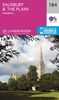
Salisbury And The Plain
Map No. 184, Salisbury and the Salisbury Plain, in the Ordnance Survey Landranger series at 1:50, 000, including Wilton, Amesbury, Collingbourne Ducis, Ludgershall, Netheravon, Tidworth, Tilshead, Market Lavington, Edington, Chitterne, Shrewton, Durrington, Bulford, Grateley, Over Wallop, Porton, Great Wishford, Stapleford, Wylye, Heytesbury, Hindon, Dinton, Tisbury, Swallowcliffe, Broad Chalke, Alderbury, West Dean, Coombe Bissett, Downton, Whiteparish, Redlynch, Normansland, Woodgreen, Martin, Damerham, Sixpenny Handley, Tollard Royal and Ludwell, with Wylye Valley, Cranborne Chase, and the north-western part of the New Forest National Park. Edition C2; Revised for selected changes 2005; Reprinted with minor change 2007; Copyright date 2007 This
title is also available on our website in a waterproof and tear-resistant version.Maps in this series are only published folded. Stanfords can also print flat versions of Ordnance Survey maps through the OS Select system, centring the map on a location of your choice and with a picture provided by you on the cover. For more information please click on the link at the bottom of this description.About Ordnance Survey
title is also available on our website in a waterproof and tear-resistant version.Maps in this series are only published folded. Stanfords can also print flat versions of Ordnance Survey maps through the OS Select system, centring the map on a location of your choice and with a picture provided by you on the cover. For more information please click on the link at the bottom of this description.About Ordnance Survey
Product Description
Reviews/Comments
Add New
Intelligent Comparison
Archived Product
Salisbury And The Plain 1919 Stanfords
£7.99
Archived Product
Salisbury And The Plain 1811-1817 Stanfords
£7.99
Archived Product
Salisbury And The Plain 1897-1899 Stanfords
£7.99
Archived Product
Salisbury And The Plain WATERPROOF Stanfords
£10.39
Archived Product
Salisbury And The Plain 1811-1817 Stanfords
£9.99
Archived Product
Salisbury And The Plain OS ACTIVE Map Stanfords
£9.09
Vouchers
No voucher codes found.
Do you know a voucher code for this product or supplier? Add it to Insights for others to use.
Do you know a voucher code for this product or supplier? Add it to Insights for others to use.
 Denmark