
 United Kingdom
 France
 Germany
 Netherlands
 Sweden
 USA
USA
 Italy
Italy
 Spain
Spain
More From Contributor

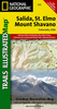

Salinas Grandes Circuit
Salinas Grandes Circuit at 1:575, 000 approx. in a series of maps of popular sightseeing routes in the northern provinces of Argentina from Asiru Editorial, presenting the region on one side with altitude coluring and on the reverse as a satellite image to provide a very clear impression of the topography. The map covers a region west of San Salvador de Jujuy and Salta, highlighting a circular tour part of which follows the famous Train to/of the Clouds route.Maps in Asiru series have on one side of a map with altitude colouring and plenty of spot heights and names of various mountain ranges, valleys, rivers and lakes, salt flats, nature reserves, etc. Locations along the highlighted route and selected other places are annotated with their altitude above the sea level. The map shows
local road and rail networks, distinguishing between paved and unpaved roads, showing driving distances, and marking locations of fuel supplies. A separate diagram of the road network shows main towns and villages annotated with facilities and services provided in them. The maps have latitude and longitude margin ticks.On the reverse the same area is shown as a satellite image to provide an alternative view of the region
local road and rail networks, distinguishing between paved and unpaved roads, showing driving distances, and marking locations of fuel supplies. A separate diagram of the road network shows main towns and villages annotated with facilities and services provided in them. The maps have latitude and longitude margin ticks.On the reverse the same area is shown as a satellite image to provide an alternative view of the region
Product Description
Reviews/Comments
Add New
Vouchers
No voucher codes found.
Do you know a voucher code for this product or supplier? Add it to Insights for others to use.
Do you know a voucher code for this product or supplier? Add it to Insights for others to use.
 Denmark