
 United Kingdom
 France
 Germany
 Netherlands
 Sweden
 USA
USA
 Italy
Italy
 Spain
Spain
More From Contributor


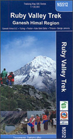
Ruby Valley Trek
Treks in the Ruby Valley area in the Ganesh Himal region of Nepal on a map at 1:100, 000 from Nepa Maps. Coverage extends from south of Trisuli Bazar and Nuwakot northwards beyond the peak of Ganesh Himal (Yangra) to the Siyar Khola Valley, and east to the Rasuwagadhi crossing to Tibet. The map prominently highlights numerous treks in the central part of this region, south of the Ganesh and the Paldor (Bhrange) massifs, including the Ganesh Himal Cultural Trek, Ganesh Himal Hot Springs Trek, Kunda Trek, etc. The trekking route along the Budhi Gandaki river and eastwards to Domje and the Ganesh Himal Base Camp is also clearly marked. Contour lines are at 40m intervals. Latitude and longitude are shown by margin ticks at 2’30” intervals. The index list places, peaks, passes and
lakes. On the inside cover are stage-by-stage distances and timings for several highlighted routes.PLEASE NOTE: the same area is also covered by the Ganesh Himal map which highlights fewer trekking routes in the central area prominently annotated in this title.Titles in this Nepa Maps series have cartography is based on the country’s topographic survey, with contours usually at 40m or 50m intervals, enhanced by relief shading, colouring and graphics to show various features of the terrain, including glaciers, forested or cultivated areas, etc. Numerous peaks, with additional spot heights, plus names of glaciers and mountain ranges are prominently shown. The network of rivers, streams and lakes is shown in great detail, with many smaller rivers and lakes named. Overprint
highlights main trekking routes and numerous local trails, with symbols indicating various places of interest and tourist facilities. Most maps are indexed and include additional information such as route profiles, glossaries, etc. All the information is in English and heights are given in metres.To see other titles in this series please click in the series link.

Product Description
Reviews/Comments
Add New
Vouchers
No voucher codes found.
Do you know a voucher code for this product or supplier? Add it to Insights for others to use.
Do you know a voucher code for this product or supplier? Add it to Insights for others to use.
 Denmark