
 United Kingdom
 France
 Germany
 Netherlands
 Sweden
 USA
USA
 Italy
Italy
 Spain
Spain
More From Contributor


Rome
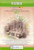
Rome on an indexed street plan at 1:17, 000 from Litografia Artistica Cartografica in their Globalmap imprint, with a large, detailed enlargement at 1:8, 500 of the city’s historic heart. 139 monuments including historic buildings and churches, archaeological remains, cultural or educational institutions, and important municipal buildings or facilities are listed in the index of places of interest, with many of them prominently marked on the plans. Metro lines and stations are clearly marked. Also provided is a large, clear diagram of the city’s metro and regional railway lines, plus a road map at 1:120, 000 showing the area roughly within the motorway ring surrounding the capital. Extensive street index is in a separate 71-page booklet attached to the map cover.Litografia
Artistica Cartografica (LAC) are Italy’s leading publishers of street plans with an extensive range of titles. Where appropriate, the plans include an enlargement showing the historic centre in greater detail. On each plan monuments including historic buildings and churches, archaeological sites, cultural or educational institutions, and important municipal buildings or facilities are numbered and listed next to the plan. Unless indicated to the contrary in the individual description, one way streets are not marked. Street index is on the reverse.
Artistica Cartografica (LAC) are Italy’s leading publishers of street plans with an extensive range of titles. Where appropriate, the plans include an enlargement showing the historic centre in greater detail. On each plan monuments including historic buildings and churches, archaeological sites, cultural or educational institutions, and important municipal buildings or facilities are numbered and listed next to the plan. Unless indicated to the contrary in the individual description, one way streets are not marked. Street index is on the reverse.

Product Description
Reviews/Comments
Add New
Vouchers
No voucher codes found.
Do you know a voucher code for this product or supplier? Add it to Insights for others to use.
Do you know a voucher code for this product or supplier? Add it to Insights for others to use.
 Denmark