
 United Kingdom
 France
 Germany
 Netherlands
 Sweden
 USA
USA
 Italy
Italy
 Spain
Spain
More From Contributor

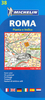


Rome Michelin Citymap
Rome at 1:12, 500 on a “write & wipe” waterproof and tear-resistant, indexed street plan from Michelin with an enlargement of the Piazza Navona area, a road map of the city’s environs, a metro diagram, plus sightseeing recommendations based on the publisher’s Green Guide.On one side is a street plan extending from the Vatican and the Trastevere district to beyond the Termini railway station, and from the Villa Borghese Park south to Terme di Caracalla and Testaccio. Accompanying inset presents in greater detail the central area from the Pantheon to the Tiber. Important buildings and places of interest are clearly marked and named, with 29 specially selected locations cross-referenced to their descriptions on the reverse. Metro stations are clearly marked. Street index, on
the reverse, includes a list of points of interest.The reverse side also includes three sections with 29 star-rated recommendations: The Essentials, Also Worth Seeing, and Our Favourites. Also provided is a road map of the Rome’s area (including access to Leonardo da Vinci and Ciampino airports), a diagram of the metro network, plus practical information (getting around, opening hours and public holidays, etc). All the text is in English.To see other titles in this series please click on the series link.
the reverse, includes a list of points of interest.The reverse side also includes three sections with 29 star-rated recommendations: The Essentials, Also Worth Seeing, and Our Favourites. Also provided is a road map of the Rome’s area (including access to Leonardo da Vinci and Ciampino airports), a diagram of the metro network, plus practical information (getting around, opening hours and public holidays, etc). All the text is in English.To see other titles in this series please click on the series link.

Product Description
Reviews/Comments
Add New
Vouchers
No voucher codes found.
Do you know a voucher code for this product or supplier? Add it to Insights for others to use.
Do you know a voucher code for this product or supplier? Add it to Insights for others to use.
 Denmark