More From Contributor
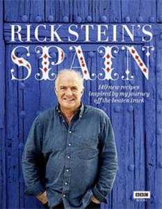
£2.50
Spanish in the Fast Talk Series from Lonely Planet, comprising a selection of handy, pocket-sized language guides designed to be practical & easy to use. Each guide provides essential language for short trips & covers a range of different situations with appropriate vocabulary. There are individual sections entitled Chat, Explore, (sights) Shop, Enjoy, (what’s on & small talk) Eat & Drink, Services, (including bank & post office vocabulary) Go, (transport) Sleep, Work (business) & Help (emergencies & police), all with easy pronunciation guides. A ‘ Look Up’ section provides useful information on numbers, colours & time & dates. There are also comprehensive English-French & French-English dictionaries, allowing users to look up vocabulary easily. ...
Archived Product
£10.99
One of the titles in a series of detailed, indexed touring maps with plenty of tourist information. Southern Norway is shown at 1:250, 000, with the two northern sheets at 1:400, 000. Relief shading with spot heights indicates the terrain, with forested areas & natural features such as glaciers clearly marked. Road network

Includes::
private roads, toll routes, restrictions & winter closures, steep gradients, motorway service areas & accommodation, scenic routes, & intermediate driving distances on most roads. Railway network with stations & ferry connections are also marked. The maps also show large amount of tourist information: recreational facilities, places of interest, various types of accommodation, etc. Latitude & longitude grid is at intervals of 10’ on the two southern maps & 30` in northern Norway. A separate booklet attached to the map cover has an index of localities. Map legend

Includes::
English.


...
Archived Product
£10.99
Schlei Fjord – Schleswig area along the Baltic coast of Germany on a detailed, GPS compatible map at 1:35, 000 from Kompass with local & long-distance footpaths, cycling routes, accommodation, etc, printed on durable, waterproof & tear-resistant synthetic paper.KOMPASS HIKING & RECREATIONAL MAPS: this title is part of an extensive series covering Austria, much of Germany & the Slovenian Alps. Kompass are Europe’s largest publishers of hiking maps; their mapping of other countries, including expanding coverage of Italy, is listed on our website separately.CARTOGRAPHY: the maps are contoured with additional shading, graphic relief & colouring to provide a more detailed picture of the terrain, vegetation and/or land use. Contour interval varies from 10m in the coastal areas of Northern Germany to 40 or 50 metres in the mountainous regions. All the maps highlight local & long-distance waymarked footpaths, including climbing trails. Most titles also show cycling routes, mountain bike trails, &, the in mountainous areas, ski routes. The maps indicate various types of accommodation (selected inns & hotels, youth hostels, campsites, mountain refuges), as well as recreational facilities, places of interest, etc. Latest editions also show access by public transport with bus stops and/or Park+ Ride facilities.GEOGRAPHICAL COORDINATES: unless indicated to the contrary in the individual description, the maps have a UTM grid for GPS users. MAP LEGEND: most maps now include full English legend, particularly titles covering the Alpine areas. Some maps covering mainly eastern Austria or the less popular parts of Germany may still have a legend in German only.OTHER

Features:
selected titles include on the reverse panorama drawings of their area with names of villages, peaks, valleys, etc. and/or have a booklet with pictures of local wild flowers with their Latin names. Many titles are now published as competitively priced sets of two or more maps, offering a wider coverage.BOOKLETS: PLEASE NOTE BEFORE ORDERING
- many titles come with a booklet describing the area and/or various hiking routes. Unless indicated in the individual description that the booklet

Includes::
English, these booklets are IN GERMAN only. The booklets are not necessary to use the maps since, as stated above, full English language map legend is provided.


...
Archived Product
£3.95
Waterproof folded cycling map of Strathearn at 1:80, 000 from Harvey Maps. The cycleway is prominently highlighted with main road sections clearly marked, & distances marked in kilometres. The road network is shown, including minor roads & forest tracks; railway lines & stations are displayed. Topography is shown through use of spot heights, & altitude colouring at 75m intervals. Terrain variations such as woodland & crags are indicated. The map is GPS compatible. Points of interest & local facilities are clearly displayed, including campsites, cycle shops, accommodation, & car parks. To see other maps in this series please click on the series link. ...
Archived Product
£10.95
The Rhinogs & the nearby peaks of Snowdonia at 1:25, 000 on a waterproof & tear-resistant map from Harvey Map Services in their Superwalker series. Coverage extends from Harlech & Llanrair in the west to Trawsfynydd in the east, with Barmouth & Dolgellau on the southern edge of the map. Map legend & additional notes are also in Welsh. Current edition of this title was published in 2005. Maps in Harvey’s Superwalker series have contours at 15m intervals, with additional graphics for various types of terrain (crags, large boulders, scattered rocks) & colouring for different kinds of land use or vegetation (pastures, bogs, forests or woodl&, etc). The maps show local hiking paths, indicating where appropriate long-distance routes, & boundaries of national parks or other protected areas. Scottish titles also indicate Munro, Corbett & Graham hills. Some maps in addition highlight local cycle routes. A range of symbols mark various facilities for walkers including youth or independent hostels, campsites & caravan sites, information points, etc. Each map has a 1-km British or Irish national grid. ...
Archived Product
£5.99
The Rough Guide Spanish Phrasebook is the definitive phrasebook to help you make the most of your time in Spain. Whether you want to book a hotel room, ask what time the train leaves or buy a drink from the bar, this new phrasebook has a dictionary of over 5, 000 words & will help you communicate with the locals in no time. The free audio downloads, recorded by native Spanish speakers, can be downloaded to your computer or MP3, allowing you to listen to the correct pronunciation of essential dialogues, ideal for practicing before you go or while you`re there. There is even a regional pronunciation guide & Rough Guide travel tips, so wherever you are you can get around & speak the lingo. ” The Rough Guide Spanish Phrasebook” has an extensive two-way dictionary packed with vocabulary & a helpful menu & drinks list reader, perfect for choosing the right dish in any restaurant ...
Archived Product
£5.99
The Rough Guide Swahili Phrasebook is the definitive phrasebook to help you make the most of your time in Eastern Africa. Whether you want to book a hotel room, ask what time the train leaves or buy a drink from the bar, this new phrasebook has a dictionary of over 5, 000 words & will help you communicate with the locals in no time. The free audio downloads, recorded by native Swahili speakers, can be downloaded to your computer or MP3, allowing you to listen to the correct pronunciation of essential dialogues, ideal for practicing before you go or while you`re there. There`s even a regional pronunciation guide & Rough Guide travel tips, so wherever you are you can get around & speak the lingo. The Rough Guide Swahili Phrasebook has an extensive two-way dictionary packed with vocabulary & a helpful menu & drinks list reader, perfect for choosing the right dish in any restaurant ...
Archived Product
£6.99
Moleskine`s Cahier Journal features a heavy-duty cardboard cover, in light warm grey, with visible stitching on the spine. The pocket size ruled journal features 64 lined pages, the last 16 of which are detachable. Also included is a wide pocket for loose notes. Comes in a set of three. ...
Archived Product
£19.95
One of the titles in the 1:50, 000 topographic survey of Icel&. The series is not complete. So far 102 maps have been published, out of the total of 199, with the north-west & the east of the country not yet covered. The series has been compiled from aerial photography & has contours at 20m intervals. The maps do not give as much information on the type of the terrain & land use as the 1:100, 000 series, but the cartography

Includes::
many other

Features:
hot & cold springs & wells, streams graded by width, etc. Each map covers an area of Approx. 23 x 28 km / 14 x 17 miles. The maps have a UTM grid, with margin ticks showing latitude & longitude in steps of 5'. Map legend

Includes::
English.


...
Archived Product
£14.99
Britain’s funny, rude & delightfully odd place names, from the Twatts of northern Scotland to the Bottoms of Engl&, via the fabled Pants of Wales, are not only bewildering, but also truly world-class. Featuring over 2, 000 genuine locations, this map is a comprehensive record of Britain’s funny, rude & delightfully odd place names, to be discovered, celebrated & chortled over. Geography at its finest. Folds out to 100 cm x 89 cm. Made in Britain using FSC-certified paper. Perfect for map lovers, adventurers &, well, anyone! ...
Archived Product

Rick Stein`s Spain

Rick Stein`s Spain is the culmination of a life long passion with Spanish culinary delights, and reflects what he feels is the `duende` of Spanish cooking- it`s sense of soul and authenticity.In this beautifully designed and illustrated cookbook to accompany the television series, Rick has selected over 140 recipes that capture the authentic taste of Spain today. Rick samples his way through the specialties and hidden treats of each region, taking in the changing landscape from the mountainous northern regions through the Spanish plains to Mediterranean beaches. With over 100 location and recipe photographs, this is an ideal buy for food-lovers as well as a superb food guide to this wonderful country.
RIP - This product is no longer available on our network. It was last seen on 25.09.2019

This page now acts as a permanent archive for this product. Add more information using the comments box below to ensure it can still be found by future generations.

Use our search facility to see if it is available from an alternative contributor.
  • External links may include paid for promotion
  • Availability: Out Of Stock
  • Supplier: Stanfords
  • SKU: 9781849901352
Availability: In Stock
£26.00

Product Description

Rick Stein`s Spain is the culmination of a life long passion with Spanish culinary delights, & reflects what he feels is the `duende` of Spanish cooking- it`s sense of soul & authenticity. In this beautifully designed & illustrated cookbook to accompany the television series, Rick has selected over 140 recipes that capture the authentic taste of Spain today. Rick samples his way through the specialties & hidden treats of each region, taking in the changing landscape from the mountainous northern regions through the Spanish plains to Mediterranean beaches. With over 100 location & recipe photographs, this is an ideal buy for food-lovers as well as a superb food guide to this wonderful country.

Reviews/Comments

Add New

Price History

Vouchers

No voucher codes found.
Do you know a voucher code for this product or supplier? Add it to Insights for others to use.

Facebook

Jargon Buster

Television - A device used for receiving moving images and sound
Spain - A country within the EU.
Spanish - The main language spoken in Spain and Latin America.
Ideal - Something that satisfies a perfect criteria.
Wonderful - Another word for describing something that is extremely good, marvellous.

Supplier Information

Stanfords
Stanfords was established in 1853 and opened their iconic Covent Garden flagship store in 1901. They have become the top retailer of maps, travel books and accessories in the UK and arguably offer the largest selection of maps and travel books worldwide. Famous names such as Captain Robert Falcon Scott, Ranulph Fiennes and Michael Palin have purchased from Stanfords. They now have a shop in Bristol and both stores together with other venues operate a calendar of events including talks, book signings and exhibitions. As a specialist map retailer, the map selection is comprehensive and includes road maps, street maps and walking maps from worldwide destinations, as well as a selection of world atlases and wall maps. Books include travel guides and travel literature. Stanfords also stock globes, from miniatures made of blue marble to magnificent floor-standing globes. The website features a selection of interesting articles on travel topics.
Page Updated: 2023-11-12 20:15:36

Community Generated Product Tags

Oh No! The productWIKI community hasn't generated any tags for this product yet!
Menu