
 United Kingdom
 France
 Germany
 Netherlands
 Sweden
 USA
USA
 Italy
Italy
 Spain
Spain
More From Contributor


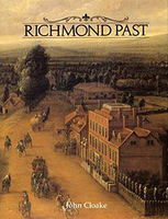
Richmond Past
Originally, the area was known as Sheen; Richmond is a comparatively new name. In 1501 when Henry VII rebuilt a royal palace here, he called it Richmond Palace, after his earldom in Yorkshire. Despite the abandonment of the palace by the 18th century, the village flourished, Many of the handsome houses of that time survive, including those in Petersham and Ham. Its Quinlan Terry riverfront development continues to provoke debate. John Cloake, Richmond`s pre-eminent historian, has included many illustrations in this comprehensive account.

Product Description
Reviews/Comments
Add New
Intelligent Comparison
Archived Product

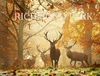
Richmond Park Stanfords
£25.00
Vouchers
No voucher codes found.
Do you know a voucher code for this product or supplier? Add it to Insights for others to use.
Do you know a voucher code for this product or supplier? Add it to Insights for others to use.
 Denmark