More From Contributor
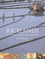
£11.50
Topographic survey of France at 1:25, 000 in IGN`s excellent TOP25 / Série Bleue series. All the maps are GPS compatible, with a 1km UTM grid plus latitude & longitude lines at 5’ intervals. Contours are at 5m intervals except for mountainous areas where the maps have contours at 10m intervals, vividly enhanced by hill shading & graphics for rocky terrain. Colouring with graphics indicates different types of vegetation or land use (deciduous or coniferous forests, moors, orchards, vineyards, etc). PLEASE NOTE: coverage of France at this scale is currently being revised – the format & the presentation of each title are indicated by the letters at the end of its Sheet Reference number (e.g. 0416ET, 3531ETR, 1923SB, etc.)MAPS WITH FULL TOURIST OVERPRINT & AN ENGLISH MAP LEGEND: all TOP25 maps & the SB editions of Série Bleue have an overprint highlighting waymarked walking trails including long-distance GR routes &, where appropriate, ski routes. Symbols indicate campsites, gîtes d’etape, refuges, equestrian centres & other recreational facilities or sites, tourist information centres, cultural heritage, etc. Towns & locations of particular interest are highlighted.- ET or OT = single-sided TOP25 map covering approx. 29x 21 km / 18x 13 miles.- ETR or OTR = waterproof & tear resistant TOP25 map covering the same area as the corresponding ET or OT number, but double-sided, printed on a smaller size sheet with a good overlap between the sides.- SB = Série Bleue map with full tourist overprint; these maps, first introduced in summer 2014, each cover approx. 29x 24km / 18x 15 miles.SÉRIE BLEUE maps with numbers ending in E (Est) or O (Ouest): most editions now indicate the GR routes, but do not show any other tourist information. Map legend is in French only. Each map covers approx. 14x 20km / 9x 12 miles. ...
Archived Product
£6.95
Topographic coverage of mainland Spain at 1:50, 000 in the MTN50 (Mapa Topográfico Nacional) series from the Centro Nacional de Información Geografica, the country’s civilian survey organization. The maps have contours at 20m intervals, enhanced by relief shading, plus colouring and/or graphics to show different types of terrain, vegetation or land use. Boundaries of national parks & other protected areas are marked. In addition to all the usual information featured on topographic mapping at this scale, detailed presentation of the road & rail networks, rural tracks & paths, etc, the maps also show campsites & mountain refuges. On more recent editions some GRs, the official long-distance hiking routes, are also marked (although not as clearly as on hiking maps from other publishers). Each map covers 29.5x 18.5 km (with adjustments in the border or coastal areas). The maps have a 1-km UTM grid, plus margin ticks for latitude & longitude at 1` intervals. Map legend is in Spanish only.HOW TO CHOOSE THE RIGHT 50K MAP: all the titles in CNIG’s 200K Provincial Road Maps series at 1:200, 000 are overprinted with the grid for the 1:50, 000 maps & can be used to see the area covered by each 50K title. TO SEE THE LIST OF TITLES IN THIS SERIES PLEASE CLICK ON THE SERIES LINK.PLEASE NOTE
- MAP TITLES: the grids shown on our website serve both the civilian & the military 1:50, 000 topographic series. Although the areas covered by maps in both series are identical (apart from some border or coastal sheets), occasionally map titles differ – only one title is shown on the grid, usually the military one. In Galicia, the Basque country & in the Catalan speaking areas the tendency now is to use local place names rather than the often better known Castilian ones. Where possible, both versions are included in our titles. Map titles listed on our website are based on information received by us at the time of publication, but sometimes maps arrive showing a completely different title! As long as the map number is as ordered, the correct map has been supplied.
...
Archived Product
£10.99
Topographic survey of Catalonia at 1:50, 000 from the Institut Cartogràfic de Catalunya, with vivid presentation of the terrain & an overprint for long-distance GR hiking trails. The series provides an excellent alternative to the much smaller sheets in the civilian or military surveys produced for the whole of Spain. The Catalan 50K series has not only a much larger area per sheet (each map covers one comarca, an administrative division of a province) than the maps from the national surveys, but also has more colourful, elegant & clear cartography with contours at 20m intervals, hill shading & fine graphics to portray the relief, vegetation types & landmarks. Most maps also have more tourist-related information, with an overprint highlighting long-distance GR trails & the Via Verde routes. Mountain refuges are marked & a range symbols indicate various places of interest including historical monuments, sport & recreational facilities, etc. Four different types of interesting locations are highlighted: picturesque towns or villages, individual isolated building or monuments, natural sites, & hydrographic features such as waterfalls. The maps have a 5km UTM grid, with latitude & longitude values shown for the map corners. Map legend is in Catalan only. To see other titles in this series please click on the series link. ...
Archived Product
£12.99
Topographic survey of France at 1:25, 000 in IGN`s excellent TOP25 / Série Bleue series. All the maps are GPS compatible, with a 1km UTM grid plus latitude & longitude lines at 5’ intervals. Contours are at 5m intervals except for mountainous areas where the maps have contours at 10m intervals, vividly enhanced by hill shading & graphics for rocky terrain. Colouring with graphics indicates different types of vegetation or land use (deciduous or coniferous forests, moors, orchards, vineyards, etc). PLEASE NOTE: coverage of France at this scale is currently being revised – the format & the presentation of each title are indicated by the letters at the end of its Sheet Reference number (e.g. 0416ET, 3531ETR, 1923SB, etc.)MAPS WITH FULL TOURIST OVERPRINT & AN ENGLISH MAP LEGEND: all TOP25 maps & the SB editions of Série Bleue have an overprint highlighting waymarked walking trails including long-distance GR routes &, where appropriate, ski routes. Symbols indicate campsites, gîtes d’etape, refuges, equestrian centres & other recreational facilities or sites, tourist information centres, cultural heritage, etc. Towns & locations of particular interest are highlighted.- ET or OT = single-sided TOP25 map covering approx. 29x 21 km / 18x 13 miles.- ETR or OTR = waterproof & tear resistant TOP25 map covering the same area as the corresponding ET or OT number, but double-sided, printed on a smaller size sheet with a good overlap between the sides.- SB = Série Bleue map with full tourist overprint; these maps, first introduced in summer 2014, each cover approx. 29x 24km / 18x 15 miles.SÉRIE BLEUE maps with numbers ending in E (Est) or O (Ouest): most editions now indicate the GR routes, but do not show any other tourist information. Map legend is in French only. Each map covers approx. 14x 20km / 9x 12 miles. ...
Archived Product
£16.99
With Australian tourists flocking to Japan in numbers greater than ever before, Rice, Noodle, Fish coulnd`t have arrived in a better moment. Part travel guide, part cultural celebration, this is the perfect book for anyone obsessed with food (and aren`t we all!). Celebrated traveller & writer, Matt Goulding, navigates the intersection between food, history & culture. Organised into seven key regions, Rice, Noodle, Fish explores Japan`s most intriguing culinary disciplines in an informative, intelligent, jovial manner. From the kaiseki of Kyoto & sushi masters of Tokyo, to the street food of Osaka & the ramen of Fukuoka, Rice, Noodle, Fish countless facts you never knew & would never have guessed. Its a wonderfully detailed, artful book that will have you appreciating your japanese adventure that much more. ...
Archived Product
£10.00
Rich
- Midelt region in a series of GPS compatible maps at 1:160, 000 published by EWP & West Col Productions & covering Morocco’s
...
Archived Product
£7.99
Young Bostonian Robert Booth manoeuvres an entree into the Florentine residence of Robert & Elizabeth Barrett Browning. When Mr Browning is called away, Booth follows him
- & is brought to the village of his childhood sweetheart, who is now hanging by the neck from a tree in the garden.
...
Archived Product
£9.99
Richard III is accused of murdering his nephews (the ` Princes in the Tower`) in order to usurp the throne of Engl&. Since Tudor times he has been painted as the `black legend`, the murderous uncle. However, the truth is much more complicated & interesting. Rather than looking at all the killings Richard III did not commit, this book focuses on the one execution for which we know that he was responsible. On Friday 13 June 1483, William, Lord Hastings was hustled from a meeting of the Royal Council & summarily executed on Tower Green within the confines of the Tower of London. Peter A. Hancock sheds light on the mystery of this precipitate & unadvised action by the then Duke of Gloucester & reveals the key role of William Catesby in Richard`s ascent to the throne of Engl&. It explains his curious actions during that tumultuous summer of three kings & provides an explanation for the fate of the ` Princes in the Tower`. ...
Archived Product
£9.99
This

Includes::
a new foreword by the author. The story of the death, in sinister circumstances, of the boy-king

...
Archived Product
£9.99
Following the dramatic announcement that Richard III`s body had been discovered, past controversies have been matched by fresh disputes. Why is Richard III England`s most controversial king? The question of his reburial has provoked national debate & protest, taking levels of interest in the medieval king to an unprecedented level. While Richard`s life remains able to polarise opinion, the truth probably lies somewhere between the maligned saint & the evil hunchback stereotypes. Why did he seize the throne? Did he murder the Princes in the Tower? Why have the location & details of his reburial sparked a parliamentary debate? This book will act as both an introduction to his life & reign & a commemoration to tie in with his reburial. ...
Archived Product

Ricelands

Pad thai, pho soup, bao: the cuisines of South East Asia have ardent enthusiasts far beyond their native lands, and are now among the most consumed dishes in the world. But the familiar take-away menus and thriving specialist shops rest atop a compelling history of food, culture and modernity, which award-winning photographer and writer Michael Freeman explores in this comprehensive and beautifully illustrated guide to South-east Asian cuisine. ”Ricelands” takes the reader on a colourful and engaging tour through the richly layered food cultures of the region. Travelling across the landscapes of Thailand, Vietnam, Burma, Cambodia, Malaysia, Laos, Indonesia and the Philippines, Freeman explores the origins and defining characteristics of their respective cuisines, and their
evolution as they entered foreign cultures. From birds` nests gathered in Thailand`s coastal caves to the less familiar dishes of Burma and Cambodia, to the pungent durian fruit (and Westerners` often aghast reactions), the author unearths unexpected treasures and tantalizing facts about Southeast Asia and its social history.The book also examines the cooking techniques, complex spices, and agricultural economies that underpin the countries` food cultures, and considers how the informal nature of southeast Asian eating fits into the rhythms of modern-day living. A vibrantly illustrated and wide-ranging study, ”Ricelands” takes us into the heart of tropical Asia and the delicious foods that define it the world over.
RIP - This product is no longer available on our network. It was last seen on 25.09.2019

This page now acts as a permanent archive for this product. Add more information using the comments box below to ensure it can still be found by future generations.

Use our search facility to see if it is available from an alternative contributor.
  • External links may include paid for promotion
  • Availability: Out Of Stock
  • Supplier: Stanfords
  • SKU: 9781861893789
Availability: In Stock
£17.95

Product Description

Pad thai, pho soup, bao: the cuisines of South East Asia have ardent enthusiasts far beyond their native lands, & are now among the most consumed dishes in the world. But the familiar take-away menus & thriving specialist shops rest atop a compelling history of food, culture & modernity, which award-winning photographer & writer Michael Freeman explores in this comprehensive & beautifully illustrated guide to South-east Asian cuisine. ” Ricelands” takes the reader on a colourful & engaging tour through the richly layered food cultures of the region. Travelling across the landscapes of Thail&, Vietnam, Burma, Cambodia, Malaysia, Laos, Indonesia & the Philippines, Freeman explores the origins & defining characteristics of their respective cuisines, & their evolution as they entered foreign cultures. From birds` nests gathered in Thailand`s coastal caves to the less familiar dishes of Burma & Cambodia, to the pungent durian fruit (and Westerners` often aghast reactions), the author unearths unexpected treasures & tantalizing facts about Southeast Asia & its social history. The book also examines the cooking techniques, complex spices, & agricultural economies that underpin the countries` food cultures, & considers how the informal nature of southeast Asian eating fits into the rhythms of modern-day living. A vibrantly illustrated & wide-ranging study, ” Ricelands” takes us into the heart of tropical Asia & the delicious foods that define it the world over.

Reviews/Comments

Add New

Intelligent Comparison

Oooops!
We couldn't find anything!
Perhaps this product's unique.... Or perhaps we are still looking for comparisons!
Click to bump this page and we'll hurry up.

Price History

Vouchers

No voucher codes found.
Do you know a voucher code for this product or supplier? Add it to Insights for others to use.

Facebook

Jargon Buster

History - Anything that happens in the past. An acedemic subject.
World - A physical grouping, commonly used to describe earth and everything associated with ti
Day - The time it takes a planet or other space objects to complete one rotation.
Heart - An organ that pumps blood around the body. Usually related to love.
Tropical - Coming fro the work "tropics" a hot and humid area of the world.
Wide - Something with a large width.

Supplier Information

Stanfords
Stanfords was established in 1853 and opened their iconic Covent Garden flagship store in 1901. They have become the top retailer of maps, travel books and accessories in the UK and arguably offer the largest selection of maps and travel books worldwide. Famous names such as Captain Robert Falcon Scott, Ranulph Fiennes and Michael Palin have purchased from Stanfords. They now have a shop in Bristol and both stores together with other venues operate a calendar of events including talks, book signings and exhibitions. As a specialist map retailer, the map selection is comprehensive and includes road maps, street maps and walking maps from worldwide destinations, as well as a selection of world atlases and wall maps. Books include travel guides and travel literature. Stanfords also stock globes, from miniatures made of blue marble to magnificent floor-standing globes. The website features a selection of interesting articles on travel topics.
Page Updated: 2023-11-12 20:15:36

Community Generated Product Tags

Oh No! The productWIKI community hasn't generated any tags for this product yet!
Menu