More From Contributor

£14.99
Rhondda & Merthyr Tydfil area on a detailed topographic & GPS compatible map No. 166, waterproof version, from the Ordnance Survey’s 1:25, 000 Explorer series.MOBILE DOWNLOADS: this title & all the other OS Explorer maps include a code for downloading after purchase the digital version onto your smartphone or tablet for viewing on the OS smartphone app.OS EXPLORER SERIES: to see the list of all the titles in the OS Explorer series, both paper & waterproof versions, please click on the series link. The Explorer series, Ordnance Survey’s most detailed maps recommended for anyone enjoying outdoor activities, provides topographic coverage of Great Britain at 1:25, 000 on GPS compatible maps with hiking trails, cycling routes & extensive tourist information. Each printed map is available either on paper or as a waterproof & tear-resistant OS Active Map, as indicated in its title. Britain’s National Parks & other areas of particular tourist interest are presented on often double-sided OL (Outdoor Leisure) maps, whilst most standard format Explorers cover an area of 30 x 20km (approx. 19 x 12 miles). All three versions (paper, waterproof & digital) are the same & provide plenty of recreational & tourist information, indicating the traditional public right of way paths (except in Scotland where different laws apply), including bridleways & byways. National Trails & other long-distance paths are marked, as well as permissive footpaths or bridleways & on-road or traffic-free cycle routes with, where appropriate, their National/ Regional Cycle Network numbers. Boundaries of access land are clearly marked. A wide range of symbols provides additional tourist information, highlighting camping & caravanning sites, information offices & visitors’ centres, parking & picnicking places, country pubs, sport & recreational facilities including cycle hire locations & mountain biking trails, historic buildings & museums, etc. Exceptionally clear presentation of the landscape is provided by contours at 5m or in the uplands at 10m intervals, with additional spot heights plus colouring and/or graphics for different types of woodlands, orchards, heath, marshl&, scree or boulders, & other topographic features. For GPS users the maps have British National Grid lines at 1km intervals, with latitude & longitude given by margin ticks at 1`. Clearly laid out map legend

Includes::
French & German translations for the tourist information symbols.

...
Archived Product
£8.99
Rhondda & Merthyr Tydfil area on a detailed topographic & GPS compatible map No. 166, paper version, from the Ordnance Survey’s 1:25, 000 Explorer series. MOBILE DOWNLOADS: this title & all the other OS Explorer maps include a code for downloading after purchase the digital version onto your smartphone or tablet for viewing on the OS smartphone app.OS EXPLORER SERIES: to see the list of all the titles in the OS Explorer series, both paper & waterproof versions, please click on the series link. The Explorer series, Ordnance Survey’s most detailed maps recommended for anyone enjoying outdoor activities, provides topographic coverage of Great Britain at 1:25, 000 on GPS compatible maps with hiking trails, cycling routes & extensive tourist information. Each printed map is available either on paper or as a waterproof & tear-resistant OS Active Map, as indicated in its title. Britain’s National Parks & other areas of particular tourist interest are presented on often double-sided OL (Outdoor Leisure) maps, whilst most standard format Explorers cover an area of 30 x 20km (approx. 19 x 12 miles). All three versions (paper, waterproof & digital) are the same & provide plenty of recreational & tourist information, indicating the traditional public right of way paths (except in Scotland where different laws apply), including bridleways & byways. National Trails & other long-distance paths are marked, as well as permissive footpaths or bridleways & on-road or traffic-free cycle routes with, where appropriate, their National/ Regional Cycle Network numbers. Boundaries of access land are clearly marked. A wide range of symbols provides additional tourist information, highlighting camping & caravanning sites, information offices & visitors’ centres, parking & picnicking places, country pubs, sport & recreational facilities including cycle hire locations & mountain biking trails, historic buildings & museums, etc. Exceptionally clear presentation of the landscape is provided by contours at 5m or in the uplands at 10m intervals, with additional spot heights plus colouring and/or graphics for different types of woodlands, orchards, heath, marshl&, scree or boulders, & other topographic features. For GPS users the maps have British National Grid lines at 1km intervals, with latitude & longitude given by margin ticks at 1`. Clearly laid out map legend

Includes::
French & German translations for the tourist information symbols.

...
Archived Product
£14.95
A 319km route from Andermatt along the Rhone to Geneva. Detailed maps show the route & its variants & extensive information is conveyed by symbols, indicating road surface, campsites & other accommodation, repair workshops, recreational facilities, places of interest, etc. A list of various types of accommodation facilities is included.IMPORTANT
- PLEASE NOTE: ALL THE TEXT IN THIS TITLE IS GERMAN ONLY. MAP LEGEND

Includes::
ENGLISH, please see our sample image, & the information provided on the maps is sufficient to use this title without any knowledge of German, particularly in the absence of a similar product in English from other publishers. There is currently no English edition this title available in this series. About the series: All the titles have been meticulously researched & are highly regarded in their native Germany. Most titles, as indicated in their individual descriptions, also include a separate section listing selected accommodation, from hotels to campsites, youth hostels & rooms in private houses, all with addresses, telephone numbers & price range. Information on towns along each route

Includes::
a list of places of interest, with opening hours, etc. Several of the guides also have street plans.


...
Archived Product
£5.99
The Rhone Valley presented by Michelin at 1:200, 000, with additional enlargements at 1:100, 000 fom the environs of Lyon & Marseille. On one side, a map at 200K extends from Lyon to Montélimar & is accompanied by large panel showing in greater detail the environs of Lyon, including its airports & the TGV railway station. On the reverse coverage at 200K continues southwards to the Mediterranean, extending from Nîmes to Marseille & Aix-en-Provence; the environs of Marseille, including Aix, Aubagne & the Calanques are also presented in more detail at 100K. Locations worth visiting have star rating. The panels have latitude & longitude lines at 10’ intervals & each side has a separate index. Michelin Zoom series of France covers popular holiday areas with Michelin’s road mapping either adapted to provide more convenient coverage or enlarged for greater clarity. Presentation of the road network

Includes::
scenic routes & viewpoints, classification according to the number of lanes, motorway junctions indicating full or partial interchanges, motorway services & rest areas, gradients, limited height & load, entry restrictions, etc. Railway lines are included. Small symbols mark various places of interest & in the more recently published titles towns, villages & areas of particular interest are allocated star rating. Unless specified to the contrary in the individual description, the maps are indexed. All the titles have an English language map legend. To see the list of titles in this series please click on the series link.

...
Archived Product
£3.50
Rhosllanerchrugog in 1909 in a fascinating series of reproductions of old Ordnance Survey plans in the Alan Godfrey Editions, ideal for anyone interested in the history of their neighbourhood or family. The map covers the Rhosllanerchrugog area, just south of Wrexham. Coverage stretches from Johnstown High Street eastward to Llanerchrugog Hall, & from Big Wood southward to the cemetery. Features include the GWR Rhos Branch with Rhos station & Brook Street Halt, the Legacy Branch with Fennant Road Halt, Aberderfyn Halt & Ponkey Crossing Halt, the hamlets of Ponkey & Johnstown, tramways & various mineral railways, the disused Bryn-yr-Owen Colliery, Rhosllanerchrugog Brick Works, Llwyn-Einion Brick Works, Plas-yn-Rhos, St David`s church, Tan-y-clawdd, etc. A directory of Rhosllanerchrugog is on the reverse. About the Alan Godfrey Editions of the 25” OS Series: Selected towns in Great Britain & Ireland are covered by maps showing the extent of urban development in the last decades of the 19th & early 20th century. The plans have been taken from the Ordnance Survey mapping & reprinted at about 15 inches to one mile (1:4, 340). On the reverse most maps have historical notes & many also include extracts from contemporary directories. Most maps cover about one mile (1.6kms) north/south, one & a half miles (2.4kms) across; adjoining sheets can be combined to provide wider coverage.FOR MORE INFORMATION & A COMPLETE LIST OF ALL AVAILABLE TITLES PLEASE CLICK ON THE SERIES LINK. ...
Archived Product
£10.00
RHS Allotment Journal shows you how to get the most from your plot & then how to cook up the produce. With timely recipes for abundance & gluts, storage advice, crops of the month & special projects, this book will keep you on top of an active plot & refresh your mind about what`s possible. ...
Archived Product
£20.00
Want to start gardening but short on space? This is the key to a beautiful garden. Whether you`re looking to grow aubergines or alliums, fushias or ferns, these handy books with step-by-step instructions & inspiring photography will guide any budding gardener to RHS-certified success.

Includes::
Planting a Small Garden, Containers for Patios, Vegetables in a Small Garden & Easy Pruning. Each title focuses on skills used at every stage of the garden`s development, starting with designing a garden through to pruning & keeping older plants healthy. Plus plant guides containing detailed information on over 700 plants. Packed full of small garden ideas & know-how, this is the perfect new home gift for first-time home-owners, retirement downsizers, or city-dwellers looking to grow vegetables.

...
Archived Product
£20.00
2013 saw the publication of the best-selling RHS Chelsea Flower Show: a Centenary Celebration. This new paperback edition for 2014 captures the magic of the 2013 show by revealing the best gardens, people, plants & events that made the show so memorable. From the first admission of gnomes to the Royal Hospital showground to controversial judging & Prince Harry`s commemorative garden, this book documents the best of the 2013 show to provide an up to date analysis of what makes Chelsea special. For 101 years, RHS Chelsea Flower Show has been the annual event in the world of horticulture. Royal Horticultural Society insider Brent Elliott explains how the show has grown & changed, how it is has formed part of the social calendar & how the nation`s taste in garden design & planting has been reflected & shaped by Chelsea over the years. Short pieces from some of our greatest nurserymen, nurserywomen & garden designers describe what Chelsea means to them, along with pieces from those who present the show to the public & those behind the scenes who pull it all together.A wealth of illustration draws from the extensive RHS archive &

Includes::
photographs in colour & black & white, plans & posters, many published here for the first time. Whether you come for the nurseries or the show gardens, to buy gardening gloves or foxgloves, or whether you simply prefer to beat the crowds & read all about it, this magnificent book conjures up the full Chelsea experience.

...
Archived Product
£20.00
A one-stop guide to creating & caring for your garden ”RHS Complete Gardener`s Manual” covers every aspect of gardening from choosing the right tools for the job & improving soil to planning a productive kitchen garden. It combines practical advice with design inspiration & step-by-step techniques with beautiful photography to help you get the best out of your garden. You can take a step towards self-sufficiency with a major section on growing your own fruit & vegetables or browse through the eye-catching catalogue of plants to see what you should be planting for every season & site. Plus, dedicated chapters focus on key gardening topics such as pruning, propagation & problem-solving. ”RHS Complete Gardener`s Manual” is a great reference guide & a one-stop manual for both new & experienced gardeners alike. ...
Archived Product
£12.98
This RHS colouring book contains forty five beautiful floral images from the world-famous RHS Lindley Library. Each image is interpreted as a pattern to colour, taking inspiration from the forms & shapes of each flower. Use the colour images to inspire you, or give your creations colours of your own choosing. ...
Archived Product

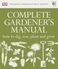
RHS A-Z Encyclopedia Of Garden Plants

This is the ultimate gardening reference: two volumes covering everything you need to know to keep your garden flourishing, from the experts at the RHS. Choose the plants you want for your garden and learn to position and care for them properly with the new edition of this perennial favourite. It offers detailed profiles of 15, 500 garden plants: from new and exotic varieties to garden favourites, that provide all the guidance you need. In this title, draw on authoritative, expert advice from Britain`s leading horticulturists on cultivation, beating pests and diseases and creating outstanding displays. It includes a special section on how to use colour and in-depth features on the most popular plants such as lilies and hostas.
RIP - This product is no longer available on our network. It was last seen on 25.09.2019

This page now acts as a permanent archive for this product. Add more information using the comments box below to ensure it can still be found by future generations.

Use our search facility to see if it is available from an alternative contributor.
  • Availability: Out Of Stock
  • Supplier: Stanfords
  • SKU: 9781405332965
Availability: In Stock
£65.00

Product Description

This is the ultimate gardening reference: two volumes covering everything you need to know to keep your garden flourishing, from the experts at the RHS. Choose the plants you want for your garden & learn to position & care for them properly with the new edition of this perennial favourite. It offers detailed profiles of 15, 500 garden plants: from new & exotic varieties to garden favourites, that provide all the guidance you need. In this title, draw on authoritative, expert advice from Britain`s leading horticulturists on cultivation, beating pests & diseases & creating outstanding displays. It

Includes::
a special section on how to use colour & in-depth features on the most popular plants such as lilies & hostas.

Reviews/Comments

Add New

Intelligent Comparison

Oooops!
We couldn't find anything!
Perhaps this product's unique.... Or perhaps we are still looking for comparisons!
Click to bump this page and we'll hurry up.

Price History

Vouchers

No voucher codes found.
Do you know a voucher code for this product or supplier? Add it to Insights for others to use.

Facebook

Jargon Buster

Garden - An outside area with grass and foliage
garden - A planned space used for the display, cultivation and enjoyment of plants and other forms of nature.
Colour - The categorised spectrum of light visable to humans
Popular - Something that is admired and liked by many people.
Reference - To prove evidence with a back up source.
perennial - A plant that lives for more than two years. Tending to bloom during spring and summer to die back to root over winter.

Supplier Information

Stanfords
Stanfords was established in 1853 and opened their iconic Covent Garden flagship store in 1901. They have become the top retailer of maps, travel books and accessories in the UK and arguably offer the largest selection of maps and travel books worldwide. Famous names such as Captain Robert Falcon Scott, Ranulph Fiennes and Michael Palin have purchased from Stanfords. They now have a shop in Bristol and both stores together with other venues operate a calendar of events including talks, book signings and exhibitions. As a specialist map retailer, the map selection is comprehensive and includes road maps, street maps and walking maps from worldwide destinations, as well as a selection of world atlases and wall maps. Books include travel guides and travel literature. Stanfords also stock globes, from miniatures made of blue marble to magnificent floor-standing globes. The website features a selection of interesting articles on travel topics.
Page Updated: 2023-11-12 20:15:36

Community Generated Product Tags

Oh No! The productWIKI community hasn't generated any tags for this product yet!
Menu