
 United Kingdom
 France
 Germany
 Netherlands
 Sweden
 USA
USA
 Italy
Italy
 Spain
Spain
More From Contributor


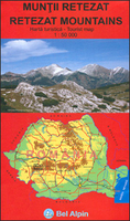
Retezat Mountains
Retezat Mountains in Romania on a detailed, contoured and GPS compatible, waterproof and tear-resistant map at 1:50, 000 from Bel Alpin, highlighting local hiking trails, plus brief descriptions of 29 selected routes provided on the reverse, and a road map of the surrounding area.The map has contours at 20m intervals with additional relief shading and colouring for woodlands. An overprint highlight hiking routes, indicating their waymarking signs, and shows chalets, refuges, campsites, hunting lodges, mountain rescue posts, etc. Latitude and longitude lines are drawn at 2’ intervals.A large inset shows the road network in the surrounding area at 1:350, 000 with vivid altitude colouring. On the reverse are notes about the regions, details of accommodation possibilities, plus
brief descriptions of 29 selected hiking routes. Map legend and all the text include English.
brief descriptions of 29 selected hiking routes. Map legend and all the text include English.

Product Description
Reviews/Comments
Add New
Vouchers
No voucher codes found.
Do you know a voucher code for this product or supplier? Add it to Insights for others to use.
Do you know a voucher code for this product or supplier? Add it to Insights for others to use.
 Denmark