
 United Kingdom
 France
 Germany
 Netherlands
 Sweden
 USA
USA
 Italy
Italy
 Spain
Spain
More From Contributor

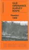


Rawtenstall 1908
Rawtenstall in 1908 in a fascinating series of reproductions of old Ordnance Survey plans in the Alan Godfrey Editions, ideal for anyone interested in the history of their neighbourhood or family. Selected towns in Great Britain and Ireland are covered by maps showing the extent of urban development in the last decades of the 19th and early 20th century.In this title: the map covers the Lancashire town of Rawtenstall, stretching from Laund and Higher Constable Lee southward to Longholme Mill, and from Oak Mount and Osborne Terrace eastward to Lower Clough Fold. Features include cemetery, Constable Lee, Collinge Fold, Chapel Hill, Leebrook Mill, bleach works, Doldrum Farm, tramways, Oakenhead Wood, Hazel Head Farm, Lower Mill, cattle market, railway with Rawtenstall station
(foot of map) and Clough End station (east margin), Hex Mill, Albion Mill, Hall Carr Mill, Victoria Works (soutyh-eastern corner), St Mary's church, Spring Side, Whitaker Park etc. A directory of Rawtenstall is included on the reverse. About the Alan Godfrey Editions of the 25
(foot of map) and Clough End station (east margin), Hex Mill, Albion Mill, Hall Carr Mill, Victoria Works (soutyh-eastern corner), St Mary's church, Spring Side, Whitaker Park etc. A directory of Rawtenstall is included on the reverse. About the Alan Godfrey Editions of the 25
Product Description
Reviews/Comments
Add New
Intelligent Comparison
Archived Product

Rawtenstall 1908 Stanfords
£3.50
Vouchers
No voucher codes found.
Do you know a voucher code for this product or supplier? Add it to Insights for others to use.
Do you know a voucher code for this product or supplier? Add it to Insights for others to use.
 Denmark