
 United Kingdom
 France
 Germany
 Netherlands
 Sweden
 USA
USA
 Italy
Italy
 Spain
Spain
More From Contributor


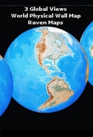
Raven Maps 3 Global Views Physical World Wall Map
Striking physical image of the world as three circular views of the continents and the surrounding oceans presented against a black background on a large, 158 x 87cm (5’2” x 2’10” approx) wall map from Raven Maps & Images.Three overlapping circular maps present most of Eurasia with Africa and the Polar Regions, the Americas, and Pacific Ocean with the Far East and Australia. The maps have bright altitude colouring and provide names of main geographical features such as mountain chains, rivers, deserts, etc.Most capitals and other large cities are indicated, but no country names or boundaries are marked. All place names are in English. Latitude and longitude lines are drawn at intervals of 15’. Projection is orthographic.

Product Description
Reviews/Comments
Add New
Vouchers
No voucher codes found.
Do you know a voucher code for this product or supplier? Add it to Insights for others to use.
Do you know a voucher code for this product or supplier? Add it to Insights for others to use.
 Denmark