More From Contributor
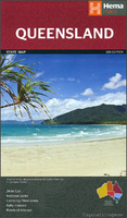
£10.99
Full of passion & betrayal, murder & war, the first volume of an epic new series from bestselling historian Alison Weir, bringing five of England`s medieval queens to life.A Daily Telegraph Book of the Year Love, murder, war, betrayal This is the story of the five extraordinary queens who helped the Norman kings of England rule their dominions. Recognised as equal sharers in the royal authority, their story is packed with tragedy, high drama, even comedy. Heroines, villains, stateswomen, lovers Beginning with Matilda of Flanders, who supported William the Conqueror in his invasion of England in 1066, & culminating in the turbulent life of the Empress Maud, whoc claimed to be queen of England in her own right & fought a bitter war to the end, the five Norman queens are revealed as hugely influential figures & fascinating characters. In Alison Weir`s hands, these pioneering women reclaim their rightful roles at the centre of English history. ...
Archived Product
£20.00
The story of England`s medieval queens is vivid & stirring, packed with tragedy, high drama & even comedy. It is a chronicle of love, murder, war & betrayal, filled with passion, intrigue & sorrow, peopled by a cast of heroines, villains, stateswomen & lovers. In the first volume of this epic new series, Alison Weir strips away centuries of romantic mythology & prejudice to reveal the lives of England`s queens in the century after the Norman Conquest. Beginning with Matilda of Flanders, who supported William the Conqueror in his invasion of England in 1066, & culminating in the turbulent life of the Empress Maud, who claimed to be queen of England in her own right & fought a bitter war to that end, the five Norman queens emerge as hugely influential figures & fascinating characters. Much more than a series of individual biographies, Queens of the Conquest is a seamless tale of interconnected lives & a rich portrait of English history in a time of flux. In Alison Weir`s hands these five extraordinary women reclaim their rightful roles at the centre of English history. ...
Archived Product
£2.95
Queensbury in 1932 in a fascinating series of reproductions of old Ordnance Survey plans in the Alan Godfrey Editions, ideal for anyone interested in the history of their neighbourhood or family. Selected towns in Great Britain & Ireland are covered by maps showing the extent of urban development in the last decades of the 19th & early 20th century. In this title: the map covers the village of Queensbury & the area to the north & west. Queensbury itself, with Black Dyke Mills, is in the south-eastern corner of the map. Features here include tramway, Holy Trinity church, the mills, etc. Other hamlets & settlements include Mountain, Yews Green, Hill Top, Clayton Edge, West Scholes Gate, Raggalds, White Castle Brewery & the Bradshaw Lane area. On the reverse is a 1936 directory of Queensbury & Mountain. About the Alan Godfrey Editions of the 25 ...
Archived Product
£3.50
Queensbury in 1932 in a fascinating series of reproductions of old Ordnance Survey plans in the Alan Godfrey Editions, ideal for anyone interested in the history of their neighbourhood or family. The map covers the village of Queensbury & the area to the north & west. Queensbury itself, with Black Dyke Mills, is in the south-eastern corner of the map. Features here include tramway, Holy Trinity church, the mills, etc. Other hamlets & settlements include Mountain, Yews Green, Hill Top, Clayton Edge, West Scholes Gate, Raggalds, White Castle Brewery & the Bradshaw Lane area. On the reverse is a 1936 directory of Queensbury & Mountain. About the Alan Godfrey Editions of the 25” OS Series: Selected towns in Great Britain & Ireland are covered by maps showing the extent of urban development in the last decades of the 19th & early 20th century. The plans have been taken from the Ordnance Survey mapping & reprinted at about 15 inches to one mile (1:4, 340). On the reverse most maps have historical notes & many also include extracts from contemporary directories. Most maps cover about one mile (1.6kms) north/south, one & a half miles (2.4kms) across; adjoining sheets can be combined to provide wider coverage.FOR MORE INFORMATION & A COMPLETE LIST OF ALL AVAILABLE TITLES PLEASE CLICK ON THE SERIES LINK. ...
Archived Product
£3.50
Queensferry & Dalmeny area of Edinburgh in 1895 in a fascinating series of reproductions of old Ordnance Survey plans in the Alan Godfrey Editions, ideal for anyone interested in the history of their neighbourhood or family. The map is double-sided. The main map covers the village of Queensferry (or South Queensferry), with coverage westward to Inchgarvie. Features include Echline, NBR South Queensferry Branch, part of Port Edgar, goods station, harbour, High Street, etc. On the reverse is about half of the adjacent sheet 3.13 covering the eastern part of Queensferry, approaches & southern part of Forth Bridge, Dalmeny station & Dalmeny village. About the Alan Godfrey Editions of the 25” OS Series: Selected towns in Great Britain & Ireland are covered by maps showing the extent of urban development in the last decades of the 19th & early 20th century. The plans have been taken from the Ordnance Survey mapping & reprinted at about 15 inches to one mile (1:4, 340). On the reverse most maps have historical notes & many also include extracts from contemporary directories. Most maps cover about one mile (1.6kms) north/south, one & a half miles (2.4kms) across; adjoining sheets can be combined to provide wider coverage.FOR MORE INFORMATION & A COMPLETE LIST OF ALL AVAILABLE TITLES PLEASE CLICK ON THE SERIES LINK. ...
Archived Product
£9.95
Queensland in a series of waterproof & tear-resistant state maps of Australia, with enlargements for popular areas & diagrams of main highways. Each title presents the whole of the state on one side, with its rail & road networks. Intermediate driving distances are given on most minor unsealed roads & vehicle tracks are also marked. National parks & other protected areas are highlighted, with the topography indicated by names of mountain ranges, spot heights for main peaks, rivers & lakes. Selected places of interest are marked. On the reverse each title has enlargements of popular areas highlighting tourist routes. Neither the main map nor the enlargements have any geographical coordinates, but all are indexed. Also included are street plans showing accommodation & places of interest, & diagrams of the highways connecting the region ...
Archived Product
£11.99
Queensland & The Great Barrier Reef in the Countries & Regions series from Lonely Planet, market-leading comprehensive guides aimed at independent travellers & serving a large range of international destinations. Frank & informal in style, the guides explore an extensive range of sights, activities, accommodation, restaurants & nightlife & are designed for practical use while travelling on the road. Written & researched by a team of experts, each book is independent in its recommendations & suggestions, often offering individual takes on individual destinations. Widely recognised for their reliability, each Lonely Planet country & region guide has the same layout. Introductory sections profile the destination with individual chapters on particular highlights, getting started, (including when to go) itineraries, history, culture, arts, food & drink & the environment. Each guide is organised geographically by region, with individual sections detailing an extensive range of sights, places of interest, attractions, restaurants, nightlife, accommodation & any local activities. The guides have detailed explanations of historical context where relevant. There is also practical guidance on ...
Archived Product
£14.99
Queensland & the Great Barrier Reef Insight Guide is dedicated to exploring the destination in detail with a selection of glossy illustrations. Extensive introductory sections explore the region’s history & culture & there are also short articles written by locals about distinctive local issues, whilst selective photo-features illustrate the variety of the place. The ‘ Places’ section is grouped geographically & provides details of the area including places to visit, suggestions for tours & other activities. Each section has its own listings of the best restaurants, bars & cafes. Essential practical information is provided in the Travel Tips chapter on accommodation, shopping & local activities. A useful location finder & travel tip index with relevant page numbers are given on the inside covers. Overview street plans are also provided for the main cities in the region or country, plus a free touring map. ...
Archived Product
£13.99
Discover Queensland & the Great Barrier Reef
Pack up your 4WD & head for the end of the road at Cooktown, where happiness is
...
Archived Product
£7.99
From the glittering Gold Coast & bustling capital of Brisbane to the tropical north, where prehistoric rainforest meets the world`s greatest coral reef, Queenland`s coastline offers an unrivalled adventure playground. Explore Queensland is part of a br&-new series & is the ideal pocket companion when discovering Queensland: a full-colour guide containing 15 easy-to-follow routes with a wealth of activities on offer, including sailing from the Whitsunday Islands with their tropical beaches, sand driving on Fraser Island & spotting crocodiles in the far north`s Wet Tropics. Insight`s trademark cultural coverage perfectly sets the routes in context, with introductions to Queensland`s cuisine, theme parks, & of course, diving & snorkelling at the Great Barrier Reef. Each route guides you through an interesting area with clear directions, a detailed map & authentic places to eat & drink along the way. The directory section contains a wealth of practical information & a range of carefully selected hotels to suit all budgets. All routes are also plotted on the pull-out map. Whether you are new to the island or a repeat visitor, & however long your stay, Explore Queensland will help you discover Queensland`s sunny beauty. Ed. September 2014. ...
Archived Product

Queensland

Queensland on a double-sided map from Periplus, including area maps of Brisbane, Cairns, the Gold Coast, the Marlin Coast, Townsville and Magnetic Island. Additional street plans of Cairns, Central Brisbane and Proserpine.Queensland State is shown at 1:7, 000, 000, with the network of main roads and railways displayed and local airports highlighted. Relief shading shows the relief and spot heights are provided for the main peaks. Places of interest, dive sites and national parks are shown clearly, including the Great Barrier Reef Marine Park. Latitude and longitude lines are drawn at intervals of 5
RIP - This product is no longer available on our network. It was last seen on 25.09.2019

This page now acts as a permanent archive for this product. Add more information using the comments box below to ensure it can still be found by future generations.

Use our search facility to see if it is available from an alternative contributor.
  • External links may include paid for promotion
  • Availability: Out Of Stock
  • Supplier: Stanfords
  • SKU: 9780794600624
Availability: In Stock
£7.99

Product Description

Queensland on a double-sided map from Periplus, including area maps of Brisbane, Cairns, the Gold Coast, the Marlin Coast, Townsville & Magnetic Isl&. Additional street plans of Cairns, Central Brisbane & Proserpine. Queensland State is shown at 1:7, 000, 000, with the network of main roads & railways displayed & local airports highlighted. Relief shading shows the relief & spot heights are provided for the main peaks. Places of interest, dive sites & national parks are shown clearly, including the Great Barrier Reef Marine Park. Latitude & longitude lines are drawn at intervals of 5

Reviews/Comments

Add New

Price History

Vouchers

No voucher codes found.
Do you know a voucher code for this product or supplier? Add it to Insights for others to use.

Facebook

Jargon Buster

Gold - A precious highly conductive metal
magnetic - A susbstance affected at a microscopic level by an applied magnetic field.
Railways - A set of tracks that have been laid for the purpose of trains to travel up and down them
Network - A link and communication between things. Often computers or people.
Gold - A colour, a type of rich metal. Chemical symbol AU.

Supplier Information

Stanfords
Stanfords was established in 1853 and opened their iconic Covent Garden flagship store in 1901. They have become the top retailer of maps, travel books and accessories in the UK and arguably offer the largest selection of maps and travel books worldwide. Famous names such as Captain Robert Falcon Scott, Ranulph Fiennes and Michael Palin have purchased from Stanfords. They now have a shop in Bristol and both stores together with other venues operate a calendar of events including talks, book signings and exhibitions. As a specialist map retailer, the map selection is comprehensive and includes road maps, street maps and walking maps from worldwide destinations, as well as a selection of world atlases and wall maps. Books include travel guides and travel literature. Stanfords also stock globes, from miniatures made of blue marble to magnificent floor-standing globes. The website features a selection of interesting articles on travel topics.
Page Updated: 2023-11-12 20:15:36

Community Generated Product Tags

Oh No! The productWIKI community hasn't generated any tags for this product yet!
Menu