More From Contributor
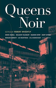
£20.00
The Kennet & Avon Canal was the wonder of its age, a broad waterway built across southern England as a trade route between the country`s two greatest ports
- London & Bristol. It changed the countryside through which it passed forever. Yet only 30 years after it was completed, Brunel`s Great Western Railway opened, robbing it of much of its traffic. After decades of neglect came ultimate dereliction. It lay like a sleeping princess, weed-choked & silent, its locks & bridges crumbling
- but some people refused to let it die. Thanks to their efforts, it was eventually restored, to become once more the Queen of Waters. Two hundred years after the first cargoes sailed along it, & twenty years on from its grand reopening, this book pays tribute to the canal that refused to die.

...
Archived Product
£9.99
Queen Victoria fell in love with the Riviera when she discovered it on her first visit to Menton in 1882 & her enchantment with this `paradise of nature` endured for almost twenty years. Victoria`s visits helped to transform the French Riviera by paving the way for other European royalty, the aristocracy & the very rich, who were to turn it into their pleasure garden. Michael Nelson paints a fascinating portrait of Victoria & her dealings with local people of all classes, statesmen & the constant stream of visiting crown heads. In the process, we see an unexpected side to Victoria: not the imperious, petulant, mourning widow but rather an exuberant girlish old lady thrilled by her surroundings. ” Queen Victoria & the Discovery of the Riviera” is an absorbing & revealing account that makes an important contribution to both our understanding of Victoria`s character & personality & our view of the late Victorian period. ...
Archived Product
£25.00
` Such a brilliant idea! Drilling down into Victoria`s diaries Worsley gives us Victoria in all her infinite variety
- queen &
...
Archived Product
£180.00
Queen-Hith Ward & Vintry Ward With Their Divisions.. ., an original antique map by B. Cole, published in London 1756. A copperplate engraving, coloured. Map size 36.5 x 24.5 cm, overall mounted size 51.5 x 38.5 cm. An attractive engraving of this small area of the City of London immediately next to the river, containing Fish Street & Lower Thames Street. An engraving of St. Michael's church accompanies coats of arms & an elaborate title cartouche. This map first appeared in Maitland's History Of London, which was sponsored by the aldermen of the city whose coats of arms appear on the maps. With a small boat in dock at Queen-Hith, & important buildings shown pictorially. Adams, London Illustrated, 38. Antique maps from various original publishers are presented on the Stanford ...
Archived Product
£10.00
Biographer & novelist A. N. Wilson, whose most recent work on the life of Queen Victoria was an enormous critical & commercial success, turns his clear eye to our own Queen, Elizabeth II, as she turns 90. In this unusual & vibrant examination of the life & times of Britain`s most iconic living figure, Wilson considers the history of the monarchy, drawing a line that stretches from Queen Victoria to the bloody history of Europe in the twentieth century, examining how & why the Royal Family has survived. He paints a vivid portrait of ` Lilibet` the woman, & of her reign, throughout which she has remained stalwart, unmoving, a trait some regard as dullness, but which Wilson argues is the key to her survival. He outlines the case for a Republic, arguing that this will almost certainly happen at some point after her reign is at an end, at least in Australia. In part historical overview, but with a keen eye to the future, A. N. Wilson writes with his signature warmth, intelligence & humour, celebrating the life of the Queen & her role as figurehead of Britain & the Commonwealth, while asking candidly whether we can remain a constitutional monarchy. ...
Archived Product
£10.99
Full of passion & betrayal, murder & war, the first volume of an epic new series from bestselling historian Alison Weir, bringing five of England`s medieval queens to life.A Daily Telegraph Book of the Year Love, murder, war, betrayal This is the story of the five extraordinary queens who helped the Norman kings of England rule their dominions. Recognised as equal sharers in the royal authority, their story is packed with tragedy, high drama, even comedy. Heroines, villains, stateswomen, lovers Beginning with Matilda of Flanders, who supported William the Conqueror in his invasion of England in 1066, & culminating in the turbulent life of the Empress Maud, whoc claimed to be queen of England in her own right & fought a bitter war to the end, the five Norman queens are revealed as hugely influential figures & fascinating characters. In Alison Weir`s hands, these pioneering women reclaim their rightful roles at the centre of English history. ...
Archived Product
£20.00
The story of England`s medieval queens is vivid & stirring, packed with tragedy, high drama & even comedy. It is a chronicle of love, murder, war & betrayal, filled with passion, intrigue & sorrow, peopled by a cast of heroines, villains, stateswomen & lovers. In the first volume of this epic new series, Alison Weir strips away centuries of romantic mythology & prejudice to reveal the lives of England`s queens in the century after the Norman Conquest. Beginning with Matilda of Flanders, who supported William the Conqueror in his invasion of England in 1066, & culminating in the turbulent life of the Empress Maud, who claimed to be queen of England in her own right & fought a bitter war to that end, the five Norman queens emerge as hugely influential figures & fascinating characters. Much more than a series of individual biographies, Queens of the Conquest is a seamless tale of interconnected lives & a rich portrait of English history in a time of flux. In Alison Weir`s hands these five extraordinary women reclaim their rightful roles at the centre of English history. ...
Archived Product
£2.95
Queensbury in 1932 in a fascinating series of reproductions of old Ordnance Survey plans in the Alan Godfrey Editions, ideal for anyone interested in the history of their neighbourhood or family. Selected towns in Great Britain & Ireland are covered by maps showing the extent of urban development in the last decades of the 19th & early 20th century. In this title: the map covers the village of Queensbury & the area to the north & west. Queensbury itself, with Black Dyke Mills, is in the south-eastern corner of the map. Features here include tramway, Holy Trinity church, the mills, etc. Other hamlets & settlements include Mountain, Yews Green, Hill Top, Clayton Edge, West Scholes Gate, Raggalds, White Castle Brewery & the Bradshaw Lane area. On the reverse is a 1936 directory of Queensbury & Mountain. About the Alan Godfrey Editions of the 25 ...
Archived Product
£3.50
Queensbury in 1932 in a fascinating series of reproductions of old Ordnance Survey plans in the Alan Godfrey Editions, ideal for anyone interested in the history of their neighbourhood or family. The map covers the village of Queensbury & the area to the north & west. Queensbury itself, with Black Dyke Mills, is in the south-eastern corner of the map. Features here include tramway, Holy Trinity church, the mills, etc. Other hamlets & settlements include Mountain, Yews Green, Hill Top, Clayton Edge, West Scholes Gate, Raggalds, White Castle Brewery & the Bradshaw Lane area. On the reverse is a 1936 directory of Queensbury & Mountain. About the Alan Godfrey Editions of the 25” OS Series: Selected towns in Great Britain & Ireland are covered by maps showing the extent of urban development in the last decades of the 19th & early 20th century. The plans have been taken from the Ordnance Survey mapping & reprinted at about 15 inches to one mile (1:4, 340). On the reverse most maps have historical notes & many also include extracts from contemporary directories. Most maps cover about one mile (1.6kms) north/south, one & a half miles (2.4kms) across; adjoining sheets can be combined to provide wider coverage.FOR MORE INFORMATION & A COMPLETE LIST OF ALL AVAILABLE TITLES PLEASE CLICK ON THE SERIES LINK. ...
Archived Product
£3.50
Queensferry & Dalmeny area of Edinburgh in 1895 in a fascinating series of reproductions of old Ordnance Survey plans in the Alan Godfrey Editions, ideal for anyone interested in the history of their neighbourhood or family. The map is double-sided. The main map covers the village of Queensferry (or South Queensferry), with coverage westward to Inchgarvie. Features include Echline, NBR South Queensferry Branch, part of Port Edgar, goods station, harbour, High Street, etc. On the reverse is about half of the adjacent sheet 3.13 covering the eastern part of Queensferry, approaches & southern part of Forth Bridge, Dalmeny station & Dalmeny village. About the Alan Godfrey Editions of the 25” OS Series: Selected towns in Great Britain & Ireland are covered by maps showing the extent of urban development in the last decades of the 19th & early 20th century. The plans have been taken from the Ordnance Survey mapping & reprinted at about 15 inches to one mile (1:4, 340). On the reverse most maps have historical notes & many also include extracts from contemporary directories. Most maps cover about one mile (1.6kms) north/south, one & a half miles (2.4kms) across; adjoining sheets can be combined to provide wider coverage.FOR MORE INFORMATION & A COMPLETE LIST OF ALL AVAILABLE TITLES PLEASE CLICK ON THE SERIES LINK. ...
Archived Product

Queens Noir

On the heels of Brookly, Manhattan and the Bronx, the borough of Queens enters the chamber of Noir. Queens county is lthe largest borough, accomodating two beaches, two airports, Aqueduct Racetrack, three elevated train structures and Shea Stadium. Queens
RIP - This product is no longer available on our network. It was last seen on 25.09.2019

This page now acts as a permanent archive for this product. Add more information using the comments box below to ensure it can still be found by future generations.

Use our search facility to see if it is available from an alternative contributor.
  • External links may include paid for promotion
  • Availability: Out Of Stock
  • Supplier: Stanfords
  • SKU: 9781933354408
Availability: In Stock
£9.99

Product Description

On the heels of Brookly, Manhattan & the Bronx, the borough of Queens enters the chamber of Noir. Queens county is lthe largest borough, accomodating two beaches, two airports, Aqueduct Racetrack, three elevated train structures & Shea Stadium. Queens

Reviews/Comments

Add New

Intelligent Comparison

Oooops!
We couldn't find anything!
Perhaps this product's unique.... Or perhaps we are still looking for comparisons!
Click to bump this page and we'll hurry up.

Price History

Vouchers

No voucher codes found.
Do you know a voucher code for this product or supplier? Add it to Insights for others to use.

Facebook

Jargon Buster

Supplier Information

Stanfords
Stanfords was established in 1853 and opened their iconic Covent Garden flagship store in 1901. They have become the top retailer of maps, travel books and accessories in the UK and arguably offer the largest selection of maps and travel books worldwide. Famous names such as Captain Robert Falcon Scott, Ranulph Fiennes and Michael Palin have purchased from Stanfords. They now have a shop in Bristol and both stores together with other venues operate a calendar of events including talks, book signings and exhibitions. As a specialist map retailer, the map selection is comprehensive and includes road maps, street maps and walking maps from worldwide destinations, as well as a selection of world atlases and wall maps. Books include travel guides and travel literature. Stanfords also stock globes, from miniatures made of blue marble to magnificent floor-standing globes. The website features a selection of interesting articles on travel topics.
Page Updated: 2023-11-12 20:15:36

Community Generated Product Tags

Oh No! The productWIKI community hasn't generated any tags for this product yet!
Menu