More From Contributor
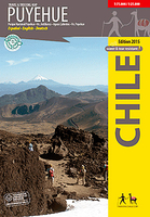
£3.50
Putney Vale in 1913 in a fascinating series of reproductions of old Ordnance Survey plans in the Alan Godfrey Editions, ideal for anyone interested in the history of their neighbourhood or family. The map covers the largely undeveloped area south of Putney & Roehampton, stretching from Richmond Park & White Lodge eastward to Putney Heath, from Manresa House & Holy Trinity church southward to Putney Vale & Robin Hood Gate. Most of the map is parkland or common, including a fragment of Wimbledon Common with a windmill, & the eastern area of Richmond Park. The area of villas called Roehampton Park is included & other features include Putney Vale cemetery, Kingston Road & Bessborough Road. About the Alan Godfrey Editions of the 25” OS Series: Selected towns in Great Britain & Ireland are covered by maps showing the extent of urban development in the last decades of the 19th & early 20th century. The plans have been taken from the Ordnance Survey mapping & reprinted at about 15 inches to one mile (1:4, 340). On the reverse most maps have historical notes & many also include extracts from contemporary directories. Most maps cover about one mile (1.6kms) north/south, one & a half miles (2.4kms) across; adjoining sheets can be combined to provide wider coverage.FOR MORE INFORMATION & A COMPLETE LIST OF ALL AVAILABLE TITLES PLEASE CLICK ON THE SERIES LINK. ...
Archived Product
£9.50
Putre
- Lauca National Park at 1:100, 000 in a series of contoured, GPS compatible trekking & exploration maps at various scales
...
Archived Product
£9.50
Topographical survey of Belgium at 1:20, 000 from Nationaal Geografisch Instituut / Institut Géographique National, the country’s national survey organization. Each 20K map covers one quarter of the corresponding 1:50, 000 map (with adjustments in the border & coastal areas). The maps provide all the information expected of topographic mapping at this scale & in addition have an unusually large amount of vegetation and/or land use information (different types of woodlands, gardens, orchards, heath, etc). The maps have a 1-km UTM grid, with margin ticks for latitude & longitude at intervals of 1`. Map legend & a glossary of terms used on the maps include English. Stanfords keeps as regular stock 20K maps for the World War I battlefields around the Ypres, Messines & Passchendaele, & for the area of the Battle of Waterloo. The 1:20, 000 survey covers the whole of Belgium & maps for other regions can be supplied as special orders. To see the list of titles in this series please click on the series link.PLEASE NOTE: the Long-Distance Footpaths Map of Belgium at 1:300, 000 which shows the division of Belgium into the 50K survey sheets can also be used to see in more detail coverage by the 20K maps. ...
Archived Product
£17.99
The 1:50, 000 topographic map gives a more general picture of the ground features than a basic map. It shows settlements, houses, roads, cultivated areas, waterways, cutting areas, mires, rock exposures, & relief. One map sheet covers an area of 30 x 40 km & one centimetre corresponds to 500 metres on the ground. The 1:50, 000 topographic map is also an ideal complement to nautical charts as it provides useful information about the land areas adjacent to waterways. For example, all Finnish sea areas are covered by 1:50, 000 topographic map sheets. ...
Archived Product
£23.99
Karttakeskus’ Water touring maps are a completely new type of map series. The pre-folded maps made from waterproof & rip-proof material can fit into a small space on the boat, but when opened, they cover a wide area. In this way, the water touring map is e.g. an excellent planning tool alongside electronic navigation solutions, offering a wide overview for e.g. route planning. On the other h&, the waterproof material makes the map easy to handle in e.g. an open boat or sailing boat. Water touring maps: In land areas, the maps have been supplemented with the National Land Survey of Finland’s Topographic Database material. New map sheet division. Size 70 × 100 cm, folded 23.3 × 11.3 cm. Additional themes incl. slipways & camp fire sites & landfalls. Scale in maritime areas 1:60 000, inland waterways 1:50 000 Base map source: Finnish Transport Agency. Not for navigation use. Does not meet the requirements of an official nautical chart. ...
Archived Product
£11.50
Topographic survey of France at 1:25, 000 in IGN`s excellent TOP25 / Série Bleue series. All the maps are GPS compatible, with a 1km UTM grid plus latitude & longitude lines at 5’ intervals. Contours are at 5m intervals except for mountainous areas where the maps have contours at 10m intervals, vividly enhanced by hill shading & graphics for rocky terrain. Colouring with graphics indicates different types of vegetation or land use (deciduous or coniferous forests, moors, orchards, vineyards, etc). PLEASE NOTE: coverage of France at this scale is currently being revised – the format & the presentation of each title are indicated by the letters at the end of its Sheet Reference number (e.g. 0416ET, 3531ETR, 1923SB, etc.)MAPS WITH FULL TOURIST OVERPRINT & AN ENGLISH MAP LEGEND: all TOP25 maps & the SB editions of Série Bleue have an overprint highlighting waymarked walking trails including long-distance GR routes &, where appropriate, ski routes. Symbols indicate campsites, gîtes d’etape, refuges, equestrian centres & other recreational facilities or sites, tourist information centres, cultural heritage, etc. Towns & locations of particular interest are highlighted.- ET or OT = single-sided TOP25 map covering approx. 29x 21 km / 18x 13 miles.- ETR or OTR = waterproof & tear resistant TOP25 map covering the same area as the corresponding ET or OT number, but double-sided, printed on a smaller size sheet with a good overlap between the sides.- SB = Série Bleue map with full tourist overprint; these maps, first introduced in summer 2014, each cover approx. 29x 24km / 18x 15 miles.SÉRIE BLEUE maps with numbers ending in E (Est) or O (Ouest): most editions now indicate the GR routes, but do not show any other tourist information. Map legend is in French only. Each map covers approx. 14x 20km / 9x 12 miles. ...
Archived Product
£5.99
A fact-packed fun book of world travel themed puzzles. Test your knowledge & get thinking with this fact-packed National Geographic Kids fun book of world travel themed puzzles. Inside are brain-tickling quizzes as well as number games, crosswords & word searches, with fascinating facts along the way. ...
Archived Product
£9.99
This fun puzzle pack contains 60 fascinating science puzzles. Challenge your friends or solve them yourself with this beautifully illustrated set of cards. The answer to each problem
- on the reverse of each card
- explains a scientific principle in easy-to-understand terms, so not only are you solving puzzles, you are having fun while you learn!

...
Archived Product
£9.99
This set of cards offers a novel approach to puzzle-solving! The problems on each card describe situations which are unusual or even bizarre, & which defy any attempt to find a ready explanation. However, the puzzles are constructed in a manner that will make the circumstances fit one
- & only one
- reasonable & logical answer.

...
Archived Product
£9.99
Join the world`s greatest fictional detective & use your own powers of deduction to solve the 60 ingenious enigmas on these cards. This collection features many types of puzzle to suit all tastes & levels of logical skill
- from `elementary` to `impenetrable`.
...
Archived Product

Puyehue

Puyehue at 1:75, 000 on a contoured, GPS compatible map form Trekkingchile, printed on light, waterproof and tear-resistant synthetic paper. The main map is at 1:75, 000, with insets for Anticura (enlarged at 1:25, 000) and Antillanca (at 1:40, 000). Contours are at 50m intervals with colouring and graphics showing different types of vegetation. The map shows local roads, paths and trekking trails, as well as shipping routes on the lakes. Symbols highlight various accommodation facilities (hotels, campsites, refuges), eateries and grocery stores, sport and recreational sites, etc. The map has a 2-km UTM grid, plus margin ticks for latitude and longitude at 1’.Maps in the Trekkingchile series use satellite imagery as a base, with contour lines and colouring to indicate
different types of terrain and habitats. Unless indicated to the contrary in the individual descriptions, the maps have a UTM grid, plus margin ticks for latitude and longitude. The maps are annotated with tourist information and most titles include a street plan of the region’s main town. Many are illustrated with drawings of local fauna or flora. Map legends and other text include English.To see the other titles in this series please click on the series link.
RIP - This product is no longer available on our network. It was last seen on 25.09.2019

This page now acts as a permanent archive for this product. Add more information using the comments box below to ensure it can still be found by future generations.

Use our search facility to see if it is available from an alternative contributor.
  • External links may include paid for promotion
  • Availability: Out Of Stock
  • Supplier: Stanfords
  • SKU: 9789568925291
Availability: In Stock
£11.99

Product Description

Puyehue at 1:75, 000 on a contoured, GPS compatible map form Trekkingchile, printed on light, waterproof & tear-resistant synthetic paper. The main map is at 1:75, 000, with insets for Anticura (enlarged at 1:25, 000) & Antillanca (at 1:40, 000). Contours are at 50m intervals with colouring & graphics showing different types of vegetation. The map shows local roads, paths & trekking trails, as well as shipping routes on the lakes. Symbols highlight various accommodation facilities (hotels, campsites, refuges), eateries & grocery stores, sport & recreational sites, etc. The map has a 2-km UTM grid, plus margin ticks for latitude & longitude at 1’. Maps in the Trekkingchile series use satellite imagery as a base, with contour lines & colouring to indicate different types of terrain & habitats. Unless indicated to the contrary in the individual descriptions, the maps have a UTM grid, plus margin ticks for latitude & longitude. The maps are annotated with tourist information & most titles include a street plan of the region’s main town. Many are illustrated with drawings of local fauna or flora. Map legends & other text include English. To see the other titles in this series please click on the series link.

Reviews/Comments

Add New

Intelligent Comparison

Oooops!
We couldn't find anything!
Perhaps this product's unique.... Or perhaps we are still looking for comparisons!
Click to bump this page and we'll hurry up.

Price History

Vouchers

No voucher codes found.
Do you know a voucher code for this product or supplier? Add it to Insights for others to use.

Facebook

Jargon Buster

GPS - Global Positioning System - Global position using satellites
Paper - A thin sheet mainly used for writing. Available in a variety of colours. Made mainly from wood pulp.
Graphics - A general term for visual aspects of an item/display
Waterproof - Resistant to water, usualy specified by depth in metres
Km - Kilometre. A unit of measurement equal to 1000 metres.
Resistant - Something that can repel against something.
Accommodation - A room in which someone can live in, for example in a hotel
Individual - A single separate item or person.

Supplier Information

Stanfords
Stanfords was established in 1853 and opened their iconic Covent Garden flagship store in 1901. They have become the top retailer of maps, travel books and accessories in the UK and arguably offer the largest selection of maps and travel books worldwide. Famous names such as Captain Robert Falcon Scott, Ranulph Fiennes and Michael Palin have purchased from Stanfords. They now have a shop in Bristol and both stores together with other venues operate a calendar of events including talks, book signings and exhibitions. As a specialist map retailer, the map selection is comprehensive and includes road maps, street maps and walking maps from worldwide destinations, as well as a selection of world atlases and wall maps. Books include travel guides and travel literature. Stanfords also stock globes, from miniatures made of blue marble to magnificent floor-standing globes. The website features a selection of interesting articles on travel topics.
Page Updated: 2023-11-12 20:15:36

Community Generated Product Tags

Oh No! The productWIKI community hasn't generated any tags for this product yet!
Menu