More From Contributor

£8.99
”A deliberate historical parable. Prater violet resembles episodes in Goodbye to Berlin & keeps up the same high level of excellence”. (Edmund Wilson). An impatient phone call from the temperamental Austrian director, Friedrich Bergmann, introduces a young Christopher Isherwood to the film industry. Isherwood`s job is to rescue the script of an idiotic love story set in nineteenth-century Vienna, a film called Prater violet. In the real Vienna of 1934 the Austrian Right crushes a socialist uprising. Bergmann is distraught & his prophecy of the coming war goes unheeded. As tensions on set grow, studio intrigues & competing egos threaten to derail the whole project. ...
Archived Product
£10.99
Prato with Montemurlo at 1:12, 000 on an indexed street plan from Litografia Artistica Cartografica, Italy’s leading publishers of city maps with an extensive range of titles. Where appropriate, the plans include an enlargement showing the historic centre in greater detail. On each plan monuments including historic buildings & churches, archaeological sites, cultural or educational institutions, & important municipal buildings or facilities are numbered & listed next to the plan. One way streets are not marked. Street index is on the reverse. ...
Archived Product
£13.99
The province of Prato, just north-west of Florence, on a double-sided, contoured & GPS compatible map at 1:25, 000 from Edizioni Multigraphic highlighting waymarked routes & other hiking paths, with access by public transports, etc. The map has contours at 20m intervals with relief shading & plenty of spot heights. Hiking paths are prominently highlighted, with routes waymarked by the Club Alpino Italiano (CAI) annotated with their numbers. The map also shows which of the routes form part of Sentiero Italia & GEA – Grande Escursione Appenninica. Icons indicate local villages with bus connections, mountain refuges, horse-ringing facilities, individual interesting trees, etc. Picturesque villages are highlighted. The map has a 1km UTM grid. Map legend

Includes::
English.

...
Archived Product
£10.00
Pratt's Map of European Aerodromes, reproduced by the Old House Books, was published in 1930 to reflect the increasing numbers of private pilots as well as airline passengers flying on business & holiday across the English Channel. The poster showing European cities with aerodromes was drawn by Leslie Mac Donald ( ...
Archived Product
£10.00
Pratt's Map of European Aerodromes Wall Map, size 87 x 63cm (34 x 25 approx), reproduced by the Old House Books, was published in 1930 to reflect the increasing numbers of private pilots as well as airline passengers flying on business & holiday across the English Channel. The poster showing European cities with aerodromes was drawn by Leslie Mac Donald ( ...
Archived Product
£7.99
` Now we make you ugly, ` my mother said. ` The best thing you can be in Mexico is an ugly girl.` On the mountainside in rural Mexico where Ladydi lives, being a girl is dangerous. Especially a pretty one. If the Narcos hear there is a pretty girl on the mountain, they steal her. So when the black SUVs roll into town, Ladydi & her friends hide in the warren of holes scattered across the mountain, safely out of sight. Because the stolen girls don`t come back. Ladydi is determined to get out, to find a life that offers more than just the struggle to survive. But she soon finds that the drug cartels have eyes everywhere, & the cities are no safer than the mountains. ...
Archived Product
£7.99
In his early years, growing up on a Dutch farm in the deep interior of the southern African Cape, Cupido Cockroach became the greatest drinker, liar, fornicator & fighter of his region. Coming under the spell of a woman, the soap-boiler Anna, & the great Dr Johannes Theodorus van der Kemp of the London Missionary Society, Cupido is then made the first Khoi or ` Hottentot` missionary ordained at the Cape of Good Hope. Received into the fold of the Church, Cupido passionately turns against all his early beliefs & is appointed as missionary in a remote & arid region in the North-western Cape. But this also marks the beginning of his decline, as the Society abandons him to his fate. One by one, the members of his congregation disappear into the desert, so that in the end, abandoned even by his wife & children, he is left to preach to the stones & thorn trees & tortoises, returning to the dream-world of his people. ...
Archived Product
£12.99
Prättigau, map No. 248, in the standard topographic survey of Switzerland at 1:50, 000 from Swisstopo, i.e. without the special overprint highlighting walking trails, local bus stops, etc, presented in Swisstopo’s hiking editions of the 50K survey. Coverage

Includes::
Davos, Klosters & Arosa. Highly regarded for their superb use of graphic relief & hill shading, the maps give an almost 3-D picture of Switzerland`s mountainous terrain. Contours are at 20m intervals. All the maps have a 1-km grid with the Swiss national coordinates. This standard version of the 50K survey covers the whole country on 78 small format sheets, with special larger format maps published for several popular tourist destinations. Small format sheets cover an area of 35 x 24 km (21 x 15 miles approx) & have map legend in the language of the area covered by the map. The special larger sheets cover 50 x 35 km (31 x 22 miles approx) & have no map legend, but a separate leaflet can be provided instead.PLEASE NOTE: the hiking editions of the 1:50, 000 Swisstopo survey are listed on our website in a separate series.

...
Archived Product
£18.99
Prättigau area, map No. 248T, at 1:50, 000 in a special hiking edition of the country’s topographic survey, published by Swisstopo in cooperation with the Swiss Hiking Federation. Coverage

Includes::
Davos, Klosters & Arosa. Cartography, identical to the standard version of the survey, is highly regarded for its superb use of graphic relief & hill shading to provide an almost 3-D picture of Switzerland`s mountainous terrain. Contours are at 20m intervals. An overprint highlights routes maintained by the SHF, distinguishing between hiking routes, mountain routes requiring proper footwear, & alpine routes where equipment is needed. Paths which are part of the national or regional network of long-distance hiking routes are specially marked & in the more recent editions are annotated with their official numbers. The maps show mountain huts, refuges & in remote areas also inns, plus roads with bus service & the positions of bus stops. All the maps have a 1-km grid of the Swiss national coordinates. For a list of all the titles in this series, please click on the series link.

...
Archived Product
£22.99
Detailed ski map at 1:50, 000 from Swisstopo, the country’s national survey organization, showing routes for skiing and/or snowboarding, access by public transport, recommended itineraries, lists of mountain huts, etc. The series uses the cartography of Switzerland’s topographic survey, with additional colouring to show slopes steeper than 30°. An overprint highlights ski routes, indicating suggested direction, difficult passages & sections which must be covered on foot. Also marked are areas where it is forbidden to leave the routes shown on the map. The maps also highlight roads with bus routes, indicating individual bus stops, show ski lifts & funiculars, plus mark locations of refuges or other mountain accommodation. Each title has the Swiss national grid at intervals of 1km, plus latitude & longitude margin ticks at 1’. Some titles cover a larger area, with a part of an adjoining sheet printed on the reverse of the main map as indicated on our series grid. Where appropriate, ski information extends across the border to France & Italy. On the reverse are itineraries of routes recommended by the Swiss Alpine Club, indicating the degree of difficulty, plus lists of alpine huts with contact details. Map legend for the overprint

Includes::
English. The text about the routes & accommodation is in the main language of the area covered by the map. To see the list of all the titles in this series please click on the series link.

...
Archived Product

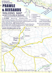
Prawle & Beesands Walking Map

Prawle and Beesands area of southern Devon on a very detailed, GPS compatible hiking, cycling and horse riding map from Croydecycle at 1:12, 500, printed on light, waterproof and tear-resistant synthetic paper. The map is part of publishers’ series covering the western coast of Somerset, both coastlines of Devon, and the adjoining areas of Dorset. Each handy size, 50 x 35cm, map is double-sided to cover a wider area. Topography is indicated by contours at 10m intervals with graphics and/or colouring for different type of terrain (sand, shingle, mud, high or low cliffs, etc) and vegetation (woodlands, gorse, scrub, etc). An overprint highlights footpaths, permissive paths and small permissive paths, Bridleways, cycle tracks and country roads which are byways for all
traffic. On other roads markings indicate routes which are part of the National Cycle Network. Symbols show locations of campsites and caravan sites, riding stables, pubs/cafes/restaurants, shops and other local facilities, etc. For GPS users each map has in the margins National Grid coordinates. Most 1:12, 500 maps include enlargements of main town(s), an inset providing geological information, and details of transport options.To see other titles in this series, including cycle maps, please click on the series link. The 1:12, 500 maps are numbered on our website westwards along the Somerset and north Devon coast, and then eastwards along the southern coast of Devon and into Dorset.
RIP - This product is no longer available on our network. It was last seen on 25.09.2019

This page now acts as a permanent archive for this product. Add more information using the comments box below to ensure it can still be found by future generations.

Use our search facility to see if it is available from an alternative contributor.
  • Availability: Out Of Stock
  • Supplier: Stanfords
  • SKU: 9780956613035
Availability: In Stock
£2.99

Product Description

Prawle & Beesands area of southern Devon on a very detailed, GPS compatible hiking, cycling & horse riding map from Croydecycle at 1:12, 500, printed on light, waterproof & tear-resistant synthetic paper. The map is part of publishers’ series covering the western coast of Somerset, both coastlines of Devon, & the adjoining areas of Dorset. Each handy size, 50 x 35cm, map is double-sided to cover a wider area. Topography is indicated by contours at 10m intervals with graphics and/or colouring for different type of terrain (s&, shingle, mud, high or low cliffs, etc) & vegetation (woodlands, gorse, scrub, etc). An overprint highlights footpaths, permissive paths & small permissive paths, Bridleways, cycle tracks & country roads which are byways for all traffic. On other roads markings indicate routes which are part of the National Cycle Network. Symbols show locations of campsites & caravan sites, riding stables, pubs/cafes/restaurants, shops & other local facilities, etc. For GPS users each map has in the margins National Grid coordinates. Most 1:12, 500 maps include enlargements of main town (s), an inset providing geological information, & details of transport options. To see other titles in this series, including cycle maps, please click on the series link. The 1:12, 500 maps are numbered on our website westwards along the Somerset & north Devon coast, & then eastwards along the southern coast of Devon & into Dorset.

Reviews/Comments

Add New

Intelligent Comparison

Oooops!
We couldn't find anything!
Perhaps this product's unique.... Or perhaps we are still looking for comparisons!
Click to bump this page and we'll hurry up.

Price History

Vouchers

No voucher codes found.
Do you know a voucher code for this product or supplier? Add it to Insights for others to use.

Facebook

Jargon Buster

GPS - Global Positioning System - Global position using satellites
Paper - A thin sheet mainly used for writing. Available in a variety of colours. Made mainly from wood pulp.
Hiking - An outdoor activity envolving walking in nature
Graphics - A general term for visual aspects of an item/display
Waterproof - Resistant to water, usualy specified by depth in metres
Mud - A combination of water and soil/clay/silt. Oftern brown in colour
Size - is the measurement of how big an object is in space.
Network - A link and communication between things. Often computers or people.
Small - something that takes up less space than normal.
Resistant - Something that can repel against something.
Horse - A large animal with four legs that tends to be ridden.
Transport - Something that carries people or goods.

Supplier Information

Stanfords
Stanfords was established in 1853 and opened their iconic Covent Garden flagship store in 1901. They have become the top retailer of maps, travel books and accessories in the UK and arguably offer the largest selection of maps and travel books worldwide. Famous names such as Captain Robert Falcon Scott, Ranulph Fiennes and Michael Palin have purchased from Stanfords. They now have a shop in Bristol and both stores together with other venues operate a calendar of events including talks, book signings and exhibitions. As a specialist map retailer, the map selection is comprehensive and includes road maps, street maps and walking maps from worldwide destinations, as well as a selection of world atlases and wall maps. Books include travel guides and travel literature. Stanfords also stock globes, from miniatures made of blue marble to magnificent floor-standing globes. The website features a selection of interesting articles on travel topics.
Page Updated: 2023-11-12 20:15:36

Community Generated Product Tags

Oh No! The productWIKI community hasn't generated any tags for this product yet!
Menu